
Venue Residences
3688 Overland Ave,
Los Angeles, CA 90034
$2,645 - $6,995
Studio - 2 Beds

This 68 unit building is steps away from shops such as Best Buy, Target, Pinks, restaurants, Hollywood and Highland Shopping Center, Sunset and Hollywood Nightlife, and much much more! One block from the West Hollywood Gateway. Ralphs supermarket around the corner, and Trader Joe’s minutes away. Close to Runyon Canyon and other hiking.
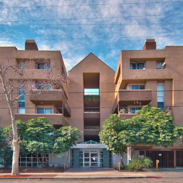
1229 N Sycamore Ave is an apartment community located in Los Angeles County and the 90038 ZIP Code. This area is served by the Los Angeles Unified attendance zone.
Fitness Center
Laundry Facilities
Elevator
Recycling
Air Conditioning
Dishwasher
Hardwood Floors
Walk-In Closets
Granite Countertops
Microwave
Refrigerator
Tub/Shower
There are numerous nicknames for Los Angeles, just as there are various vibes within this sprawling city. Between rugged mountains and sandy shorelines, a laid-back surf culture and a high-powered commercial district, and food trucks and some of the world’s top-rated restaurants, Los Angeles features diversity in every aspect possible. Somehow, all the pieces of this city fit together seamlessly, making Los Angeles the unique destination we know and love. From Rodeo Drive and Beverly Hills to Hollywood and Chinatown, there is the perfect neighborhood for everyone in Los Angeles.
From celebrity sightings to unbeatable shopping destinations, Los Angeles is hard to beat. Enjoy a hike in the Santa Monica Mountains, Griffith Park, or Topanga State Park, enjoy the famous entertainment at Universal Studios Hollywood, see the stars along the legendary Hollywood Walk of Fame, or stop into the Los Angeles County Museum of Art.
Learn more about living in Los Angeles| Colleges & Universities | Distance | ||
|---|---|---|---|
| Colleges & Universities | Distance | ||
| Walk: | 16 min | 0.9 mi | |
| Drive: | 3 min | 1.2 mi | |
| Drive: | 8 min | 4.0 mi | |
| Drive: | 10 min | 5.2 mi |


Transportation options available in Los Angeles include Hollywood/Highland Station, located 0.8 mile from 1229 N Sycamore Ave. 1229 N Sycamore Ave is near Bob Hope, located 9.2 miles or 17 minutes away, and Los Angeles International, located 12.9 miles or 26 minutes away.
| Transit / Subway | Distance | ||
|---|---|---|---|
| Transit / Subway | Distance | ||
|
|
Walk: | 15 min | 0.8 mi |
|
|
Drive: | 3 min | 1.5 mi |
|
|
Drive: | 5 min | 2.5 mi |
|
|
Drive: | 7 min | 3.8 mi |
|
|
Drive: | 8 min | 4.1 mi |
| Commuter Rail | Distance | ||
|---|---|---|---|
| Commuter Rail | Distance | ||
|
|
Drive: | 12 min | 6.7 mi |
|
|
Drive: | 14 min | 7.1 mi |
|
|
Drive: | 13 min | 7.5 mi |
|
|
Drive: | 15 min | 7.7 mi |
|
|
Drive: | 16 min | 8.1 mi |
| Airports | Distance | ||
|---|---|---|---|
| Airports | Distance | ||
|
Bob Hope
|
Drive: | 17 min | 9.2 mi |
|
Los Angeles International
|
Drive: | 26 min | 12.9 mi |
Time and distance from 1229 N Sycamore Ave.
| Shopping Centers | Distance | ||
|---|---|---|---|
| Shopping Centers | Distance | ||
| Walk: | 7 min | 0.4 mi | |
| Walk: | 8 min | 0.4 mi | |
| Walk: | 11 min | 0.6 mi |
| Parks and Recreation | Distance | ||
|---|---|---|---|
| Parks and Recreation | Distance | ||
|
Runyon Canyon
|
Walk: | 22 min | 1.2 mi |
|
La Brea Tar Pits
|
Drive: | 7 min | 2.9 mi |
|
Zimmer Children's Museum
|
Drive: | 8 min | 3.7 mi |
|
Bird Sanctuary
|
Drive: | 11 min | 4.6 mi |
|
Griffith Observatory
|
Drive: | 14 min | 5.8 mi |
| Hospitals | Distance | ||
|---|---|---|---|
| Hospitals | Distance | ||
| Drive: | 3 min | 1.2 mi | |
| Drive: | 6 min | 3.1 mi | |
| Drive: | 7 min | 3.4 mi |
| Military Bases | Distance | ||
|---|---|---|---|
| Military Bases | Distance | ||
| Drive: | 26 min | 14.6 mi |
Pets Allowed In Unit Washer & Dryer Maintenance on site Heat Controlled Access Elevator
What Are Walk Score®, Transit Score®, and Bike Score® Ratings?
Walk Score® measures the walkability of any address. Transit Score® measures access to public transit. Bike Score® measures the bikeability of any address.
What is a Sound Score Rating?
A Sound Score Rating aggregates noise caused by vehicle traffic, airplane traffic and local sources

1229 N Sycamore Ave
Los Angeles, CA 90038


