$5,450 / Month
1220 Manning Ave Unit 9
Los Angeles, CA 90024
Today
Favorites
844-451-2860
-
Bedrooms
3
-
Bathrooms
3
-
Square Feet
1,400 sq ft
-
Available
Available Now
Highlights
- Rooftop Deck
- City View
- Atrium Room
- Contemporary Architecture
- Cathedral Ceiling
- Main Floor Bedroom
1220 Manning Ave Unit 9
Favorites
About This Home
12 Month Lease
,
Available Now
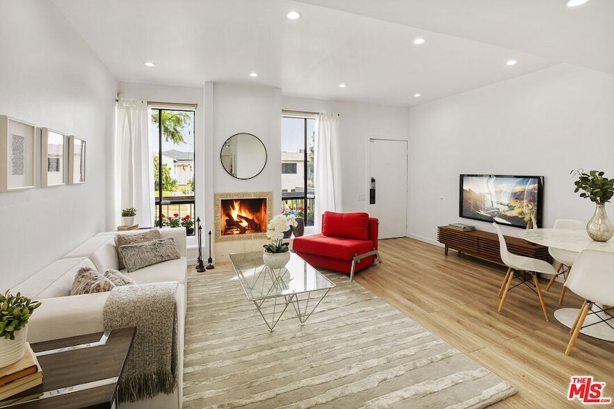
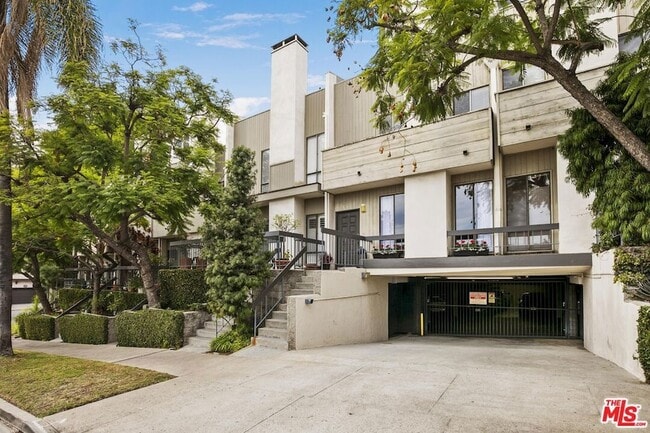
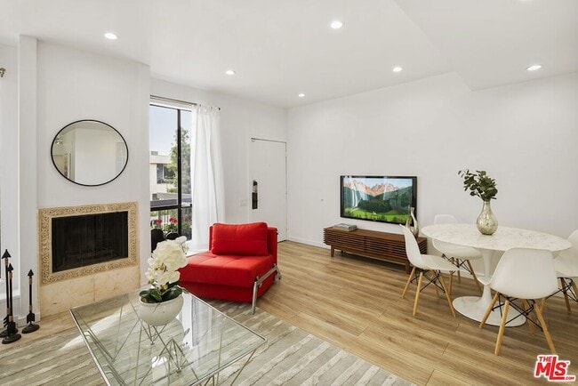
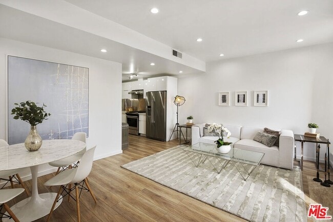
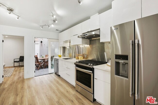
Remodeled modern 3bed+3 full baths luxury townhouse in prime Westwood. The property is a townhouse with no neighbors above or below. Turnkey with new LED recessed lighting and freshly painted. Open floor plan with lots of natural light coming in from large windows and inside atrium. Contemporary kitchen with brand new stainless steel appliances, quartz counter and washer/dryer closet. Large bedroom/den downstairs with full bath. Upstairs Master bedroom with en-suite bathroom and a guest room with en-suite bathroom. Master has 2 story vaulted wood-beamed ceiling with loft, full master-bathroom w/ two sinks, and large walk-in closet. From master walk out to a large terrace with tree top/city views for outdoor living. Close to UCLA, shopping, restaurants, transportation and the highly rated Fairburn Elementary School. Minutes to Beverly Hills, Century City and Santa Monica and much much more. Property video available.
1220 Manning Ave is a condo located in Los Angeles County and the 90024 ZIP Code.
* Price shown is base rent and may not include non-optional fees and utilities.
Price, availability, fees, and any applicable rent special are subject to change without notice.
* Square footage definitions vary. Displayed square footage is approximate.
Home Details
Home Type
Townhome
Year Built
Built in 1974 | Remodeled
Accessible Home Design
Entry on the 1st floor
Bedrooms and Bathrooms
Main Floor Bedroom
Walk-In Closet
Bathtub with Shower
Remodeled Bathroom
3 Full Bathrooms
3 Bedrooms
Flooring
Stone
Laminate
Home Design
Contemporary Architecture
Wood Siding
Home Security
Carbon Monoxide Detectors
Interior Spaces
Atrium Room
Living Room with Fireplace
Cathedral Ceiling
Built-In Features
Recessed Lighting
French Doors
Track Lighting
Ceiling Fan
1,400 Sq Ft Home
2-Story Property
Drapes & Rods
Blinds
Kitchen
Quartz Countertops
Electric Oven
Ice Maker
Range Hood
Disposal
Water Line To Refrigerator
Laundry
Laundry Room
Stacked Washer and Dryer Hookup
Listing and Financial Details
Security Deposit $5,450
1-Month Minimum Lease Term
12 Month Lease Term
Assessor Parcel Number 4326-001-048
Tenant pays for electricity, gas, cable TV
Rent includes water, trash collection, gardener
Location
City Lot
Lot Details
0.41 Acre Lot
South Facing Home
Front Yard Sprinklers
Outdoor Features
Rooftop Deck
Balcony
Enclosed Glass Porch
Parking
Controlled Entrance
2 Car Garage
Utilities
Central Heating and Cooling System
Water Purifier
Central Water Heater
Sewer in Street
Property is located within a water district
Vented Exhaust Fan
Views
City Views
Community Details
Amenities
Community Mailbox
Overview
14 Units
Association fees include maintenance paid, trash, water and sewer paid
Pet Policy
Call for details about the types of pets allowed
Fees and Policies
The fees below are based on community-supplied data and may exclude additional fees and utilities.
- Parking
-
Garage--
Details
Lease Options
-
12 Months
Location
Get Directions
Amenities
- Washer/Dryer
- Washer/Dryer Hookup
- Air Conditioning
- Heating
- Ceiling Fans
- Fireplace
- Sprinkler System
- Disposal
- Kitchen
- Oven
- Range
- Refrigerator
- Views
- Walk-In Closets
- Porch
Home to UCLA, Westwood lies on the west side of the city and is considered to be one of Los Angeles’ premier neighborhoods. Bordered by Beverly Hills, Bel Air, Brentwood, and Century City, multimillion dollar homes populate the landscape and students pay a premium to rent near campus.
The university itself serves as a major cultural center for the community, including on-campus attractions (such as the Fowler Museum and the Franklin D. Murphy Sculpture Garden) and university-affiliated venues off-campus (The Hammer Museum, the Geffen Playhouse), as well as the presence of thousands of students and faculty members throughout the neighborhood.
Directly south of campus, Westwood Village is a historic shopping district that features blocks of restaurants and businesses catering to both students and the neighborhood’s larger workforce. Many prominent corporations and law offices are found along Wilshire Boulevard, one of the busiest east-west transit corridors across the city.
Learn more about living in Westwood
Education
| Colleges & Universities | Distance | ||
|---|---|---|---|
| Colleges & Universities | Distance | ||
| Drive: | 4 min | 1.3 mi | |
| Drive: | 9 min | 3.2 mi | |
| Drive: | 10 min | 4.7 mi | |
| Drive: | 10 min | 4.7 mi |
1220 Manning Ave Unit 9 is within 4 minutes or 1.3 miles from UCLA. It is also near Santa Monica Coll., Academy and The Art Inst., Los Angeles.
Transportation options available in Los Angeles include Westwood/Rancho Park, located 2.2 miles from 1220 Manning Ave Unit 9. 1220 Manning Ave Unit 9 is near Los Angeles International, located 11.1 miles or 18 minutes away, and Bob Hope, located 17.9 miles or 27 minutes away.
| Transit / Subway | Distance | ||
|---|---|---|---|
| Transit / Subway | Distance | ||
|
|
Drive: | 6 min | 2.2 mi |
| Drive: | 6 min | 2.3 mi | |
|
|
Drive: | 8 min | 3.2 mi |
|
|
Drive: | 8 min | 4.4 mi |
|
|
Drive: | 10 min | 5.6 mi |
| Commuter Rail | Distance | ||
|---|---|---|---|
| Commuter Rail | Distance | ||
|
|
Drive: | 25 min | 13.2 mi |
|
|
Drive: | 27 min | 13.6 mi |
|
|
Drive: | 21 min | 14.3 mi |
|
|
Drive: | 27 min | 17.9 mi |
| Drive: | 28 min | 18.8 mi |
| Airports | Distance | ||
|---|---|---|---|
| Airports | Distance | ||
|
Los Angeles International
|
Drive: | 18 min | 11.1 mi |
|
Bob Hope
|
Drive: | 27 min | 17.9 mi |
Time and distance from 1220 Manning Ave Unit 9.
| Shopping Centers | Distance | ||
|---|---|---|---|
| Shopping Centers | Distance | ||
| Walk: | 11 min | 0.6 mi | |
| Walk: | 14 min | 0.8 mi | |
| Walk: | 14 min | 0.8 mi |
1220 Manning Ave Unit 9 has 3 shopping centers within 0.8 mile, which is about a 14-minute walk. The miles and minutes will be for the farthest away property.
| Parks and Recreation | Distance | ||
|---|---|---|---|
| Parks and Recreation | Distance | ||
|
Mathias Botanical Garden
|
Walk: | 13 min | 0.7 mi |
|
Hannah Carter Japanese Garden
|
Drive: | 6 min | 2.1 mi |
|
Virginia Robinson Gardens
|
Drive: | 8 min | 3.1 mi |
|
Zimmer Children's Museum
|
Drive: | 8 min | 4.3 mi |
|
Franklin Canyon Park
|
Drive: | 16 min | 5.5 mi |
1220 Manning Ave Unit 9 has 5 parks within 5.5 miles, including Mathias Botanical Garden, Hannah Carter Japanese Garden, and Virginia Robinson Gardens.
| Hospitals | Distance | ||
|---|---|---|---|
| Hospitals | Distance | ||
| Drive: | 4 min | 1.2 mi | |
| Drive: | 4 min | 1.2 mi | |
| Drive: | 9 min | 3.7 mi |
1220 Manning Ave Unit 9 has 3 hospitals within 3.7 miles, the nearest is Ronald Reagan UCLA Medical Center which is 1.2 miles away and a 4 minute drive.
| Military Bases | Distance | ||
|---|---|---|---|
| Military Bases | Distance | ||
| Drive: | 19 min | 13.7 mi |
1220 Manning Ave Unit 9 is 13.7 miles and a 19 minute drive from Los Angeles Air Force Base.
1220 Manning Ave Unit 9 Photos
About the Listing Agent
Cynthia Perez Brown
Sotheby's International Realty
Cynthia Perez-Brown has spent her career working in the real estate with seller/buyer and investors/ developers. In addition, she’s been a corporate banker working with diverse real estate clients. Her professional corporate finance experience brings the highest quality and service to all sides of the real estate process creating a secure transaction for her clients. Born in Los Angeles, Cynthia has lived in the Hollywood Hills, Beverly Hills and Brentwood area for over 30 years. She also spent many years studying abroad bringing a cosmopolitan sensitivity that benefits a broad spectrum of clients. She is a member of the Beverly Hills Greater Los Angeles Board of Realtors and is active in both cultural and education organizations.
She is currently very active in Santa Monica, Brentwood, West LA, Westwood, Mar Vista, Venice, Marina del Rey and Culver City
MLS Number: 2
What Are Walk Score®, Transit Score®, and Bike Score® Ratings?
Walk Score® measures the walkability of any address. Transit Score® measures access to public transit. Bike Score® measures the bikeability of any address.
What is a Sound Score Rating?
A Sound Score Rating aggregates noise caused by vehicle traffic, airplane traffic and local sources

1220 Manning Ave
Los Angeles, CA 90024