
$3,700 / Month
12 Aberdeen St
Boston, MA 02215
Today
Favorites
617-812-2790
-
Bedrooms
2
-
Bathrooms
1
-
Square Feet
763 sq ft
-
Available
Available Sep 1
12 Aberdeen St

Favorites
About This Home
$3,700 deposit,
Available Sep 1
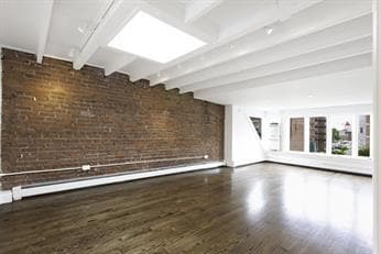
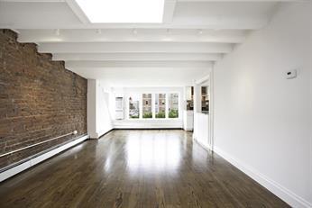
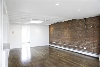
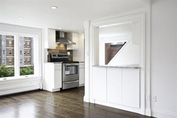
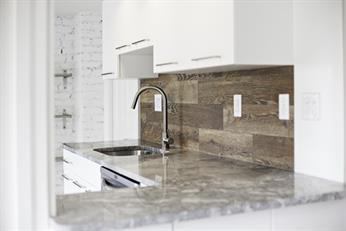
Stunning TOP floor 2 bed/1 bath available September 1st just minutes from the rapidly growing up Fenway and Kenmore area! This unit is a must see with gleaming hardwood floors, skylights throughout letting in ample natural sunlight, marble shower and exposed brick adding to the charming character of the space. Open layout kitchen and dining area are great for entertaining while you prepare in the fully renovated kitchen complete with stainless steel appliances. In unit full size laundry, easy access to MBTA Green Line, Fenway Park, shops and restaurants make this unit a must see! Iconic views of the notorious Citgo sign and Boston skyline in this rare urban gem on a private street. Heat, hot water, water/sewer and trash all included in rent.
12 Aberdeen St is a townhome located in Suffolk County and the 02215 ZIP Code. This area is served by the Boston Public Schools attendance zone.
* Price shown is base rent and may not include non-optional fees and utilities.
Price, availability, fees, and any applicable rent special are subject to change without notice.
* Square footage definitions vary. Displayed square footage is approximate.
Townhome Features
Washer/Dryer
Dishwasher
Hardwood Floors
Microwave
- Washer/Dryer
- Dishwasher
- Disposal
- Microwave
- Range
- Refrigerator
- Hardwood Floors
Contact
- Listed by Tenant
- Phone Number
- Contact
Location
Get Directions
Amenities
- Washer/Dryer
- Dishwasher
- Disposal
- Microwave
- Range
- Refrigerator
- Hardwood Floors
In a city so rich with history and culture, Fenway Park is arguably Boston’s most beloved attraction, and Audubon Circle is the perfect neighborhood for experiencing the electric energy surrounding “The Cathedral.” Although Fenway is only seven blocks from even the farthest point in Audubon Circle, it is far from the only noteworthy landmark within walking distance: amenities as diverse as Boston Beer Works, the Emerald Necklace park system, and a multiplex movie theater are all easily accessible on foot.
Most of the local apartments—which range from highly affordable to upscale-- are situated above ground-floor businesses in gorgeous historic brick buildings. Just across Saint Marys Street to the west, locals can reach a row of diverse restaurants, bakeries, and grocery stores. The Charles River and Boston University’s campus sit just a few blocks to the north; Amory Park and the New England Hebrew Academy are just minutes to the west.
Learn more about living in Audubon Circle
Education
| Colleges & Universities | Distance | ||
|---|---|---|---|
| Colleges & Universities | Distance | ||
| Walk: | 5 min | 0.3 mi | |
| Walk: | 9 min | 0.5 mi | |
| Walk: | 11 min | 0.6 mi | |
| Walk: | 11 min | 0.6 mi |
12 Aberdeen St is within 5 minutes or 0.3 mile from Lesley Univ., Art Institute. It is also near Boston University and Emmanuel College.
Schools


Public Elementary & Middle School
Grades PK-8
426 Students
Attendance Zone
Public Elementary School
Grades PK-1
111 Students
Attendance Zone
Public Middle & High School
Grades 7-12
2,423 Students
Attendance Zone
Public Middle & High School
Grades 7-12
26 Students
Attendance Zone
Charter High School
Grades 9-12
364 Students
Attendance Zone
Private Elementary & Middle School
Grades PK-8
127 Students
Nearby
Private Middle & High School
Grades 8-12
48 Students
Nearby
School data provided by
 The GreatSchools Rating helps parents compare schools within a state based on a variety of school quality indicators and provides a helpful picture of how effectively each school serves all of its students. Ratings are on a scale of 1 (below average) to 10 (above average) and can include test scores, college readiness, academic progress, advanced courses, equity, discipline and attendance data. We also advise parents to visit schools, consider other information on school performance and programs, and consider family needs as part of the school selection process.
View GreatSchools Rating Methodology
Data provided by GreatSchools.org © 2025. All rights reserved.
View GreatSchools Rating Methodology
Data provided by GreatSchools.org © 2025. All rights reserved.
Transportation options available in Boston include Fenway Station, located 0.2 mile from 12 Aberdeen St. 12 Aberdeen St is near General Edward Lawrence Logan International, located 6.3 miles or 14 minutes away.
| Transit / Subway | Distance | ||
|---|---|---|---|
| Transit / Subway | Distance | ||
|
|
Walk: | 4 min | 0.2 mi |
|
|
Walk: | 4 min | 0.2 mi |
|
|
Walk: | 6 min | 0.3 mi |
|
|
Walk: | 7 min | 0.4 mi |
|
|
Walk: | 9 min | 0.5 mi |
| Commuter Rail | Distance | ||
|---|---|---|---|
| Commuter Rail | Distance | ||
|
|
Drive: | 3 min | 1.4 mi |
|
|
Drive: | 7 min | 2.0 mi |
| Drive: | 6 min | 2.9 mi | |
|
|
Drive: | 7 min | 3.6 mi |
| Drive: | 14 min | 6.8 mi |
| Airports | Distance | ||
|---|---|---|---|
| Airports | Distance | ||
|
General Edward Lawrence Logan International
|
Drive: | 14 min | 6.3 mi |
Time and distance from 12 Aberdeen St.
| Shopping Centers | Distance | ||
|---|---|---|---|
| Shopping Centers | Distance | ||
| Walk: | 10 min | 0.5 mi | |
| Walk: | 14 min | 0.7 mi | |
| Drive: | 3 min | 1.1 mi |
12 Aberdeen St has 3 shopping centers within 1.1 miles, which is about a 3-minute walk. The miles and minutes will be for the farthest away property.
| Parks and Recreation | Distance | ||
|---|---|---|---|
| Parks and Recreation | Distance | ||
|
Coit Observatory
|
Walk: | 9 min | 0.5 mi |
|
Charles River Reservation
|
Drive: | 3 min | 1.4 mi |
|
John Fitzgerald Kennedy National Historic Site
|
Drive: | 3 min | 1.4 mi |
|
Roxbury Heritage State Park
|
Drive: | 5 min | 2.1 mi |
|
Boston Public Garden
|
Drive: | 7 min | 2.3 mi |
12 Aberdeen St has 5 parks within 2.3 miles, including Charles River Reservation, Coit Observatory, and John Fitzgerald Kennedy National Historic Site.
| Hospitals | Distance | ||
|---|---|---|---|
| Hospitals | Distance | ||
| Walk: | 11 min | 0.6 mi | |
| Walk: | 16 min | 0.8 mi | |
| Walk: | 19 min | 1.0 mi |
12 Aberdeen St has 3 hospitals within 1.0 mile, the nearest is Beth Israel Deaconess Medical Center which is 0.6 mile away and a 11 minute walk.
| Military Bases | Distance | ||
|---|---|---|---|
| Military Bases | Distance | ||
| Drive: | 27 min | 14.3 mi | |
| Drive: | 26 min | 15.2 mi |
12 Aberdeen St is 14.3 miles from Hanscom Air Force Base, and is convenient to other military bases, including US Military Reservation.
You May Also Like
Similar Rentals Nearby


What Are Walk Score®, Transit Score®, and Bike Score® Ratings?
Walk Score® measures the walkability of any address. Transit Score® measures access to public transit. Bike Score® measures the bikeability of any address.
What is a Sound Score Rating?
A Sound Score Rating aggregates noise caused by vehicle traffic, airplane traffic and local sources

12 Aberdeen St
Boston, MA 02215