

$2,900 / Month
116 48th Pl NE
Washington, DC 20019
2 Weeks Ago
Favorites
116 48th Pl NE

Favorites
Check Back Soon for Upcoming Availability
| Beds | Baths | Average SF |
|---|---|---|
| 3 Bedrooms 3 Bedrooms 3 Br | 2 Baths 2 Baths 2 Ba | 1,178 SF |
About This Property
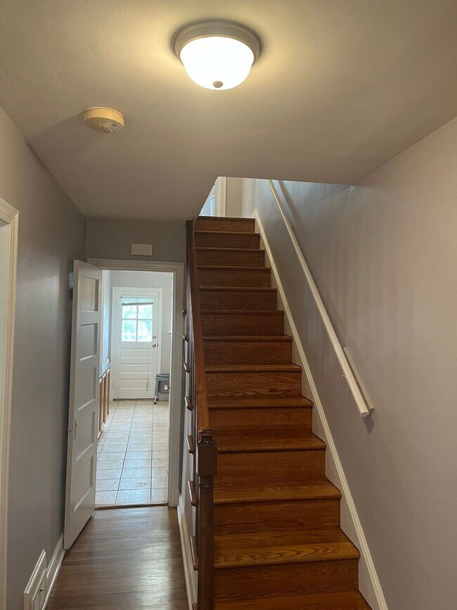
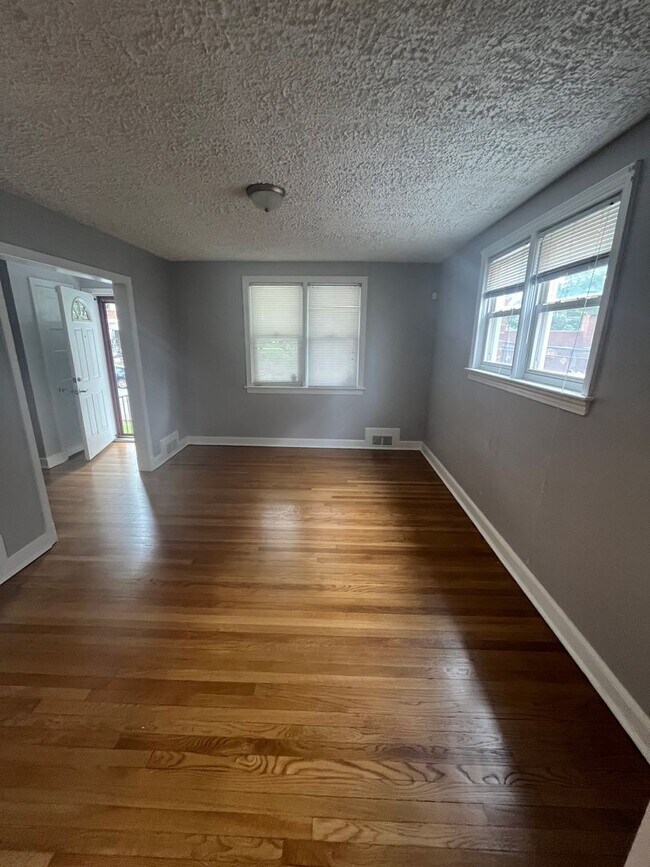
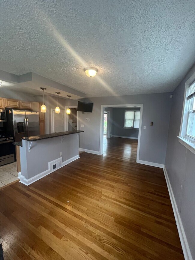
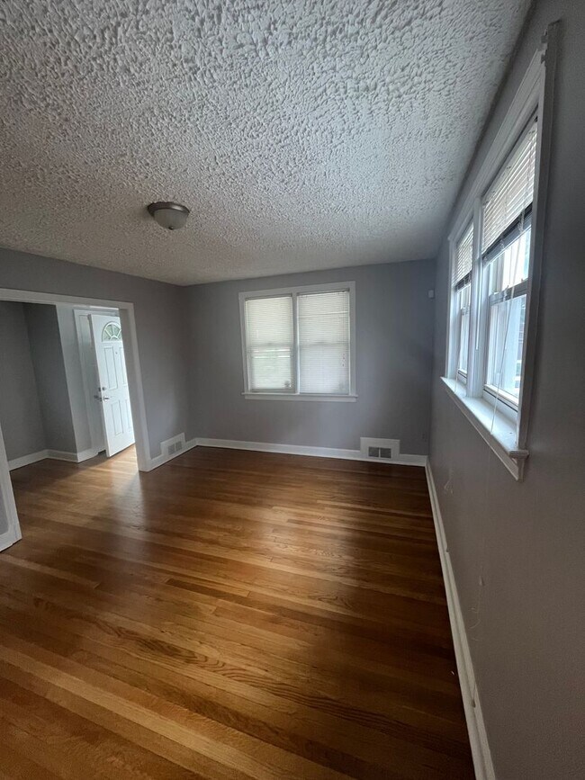
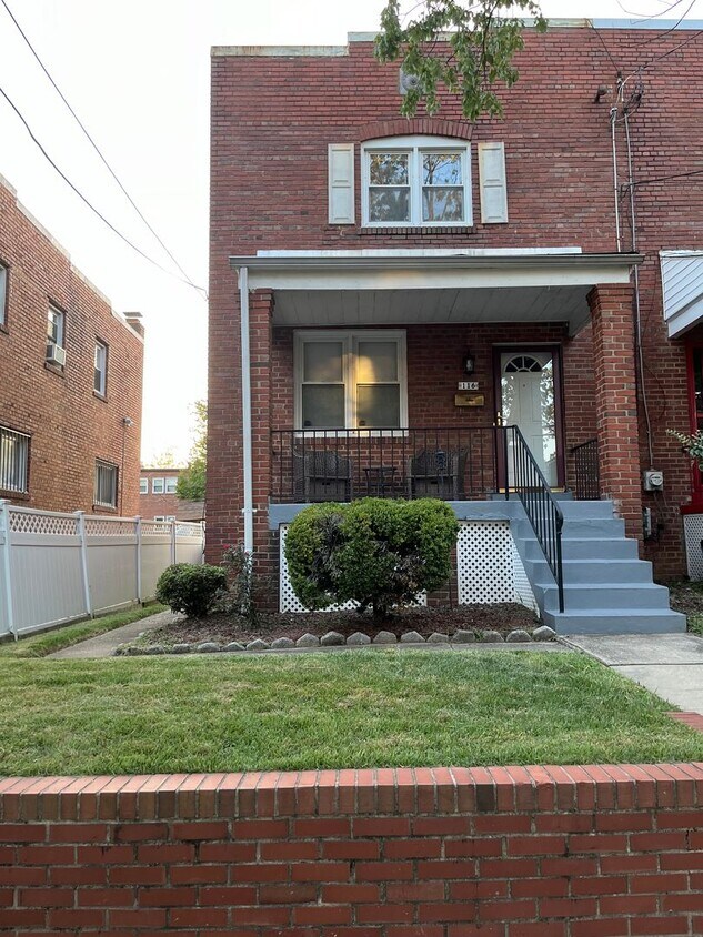
This semi-detached home is located in the Benning Heights neighborhood of North-East Washington DC. The home boasts 3 bedroom/ 2 bathrooms with a light filled main and upper level. This home features stainless steel appliances, a dining room with a breakfast bar and a backyard with an off street parking pad. The home also has hardwood floors throughout the main living area and the upper level. Finally, the home has a central air/heat, a washer/dryer and a full shower bathroom on the lower level. Within the neighborhood, there is the Benning road metro station. There is also the East River Park shopping center along Benning Road. Other neighborhood amenities include are the Dorothy I. Heights library and the Benning-Stodert community center. This home is renting for $2900 per month. The tenant is responsible for gas, electric and water utilities. For leasing inquiries, contact Dakari McAdoo at OR . Professionally Managed by KL Associates, Inc. 1350 Wallach Place, NW Washington, DC 20009 District law requires that a housing provider state that the housing provider will not refuse to rent a rental unit to a person because the person will provide the rental payment, in whole or in part, through a voucher for rental housing assistance provided by the District or federal government.
116 48th Pl NE is a house located in District of Columbia County and the 20019 ZIP Code. This area is served by the District Of Columbia Public Schools attendance zone.
Location
Get Directions
The Minnesota Avenue neighborhood follows Minnesota Avenue from Capitol Street northward to Nannie Helen Burroughs Avenue. It extends east from the Anacostia River to the Capitol View neighborhood. It includes the Minnesota Avenue Metro Station, located on the Orange line. Fort Mahan Park, located on a hill in the middle of the neighborhood, features hiking trails, a lake, and remnants of a Civil War fort. The Minnesota Avenue neighborhood is located about four miles southeast of Downtown DC.
Learn more about living in Minnesota AveBelow are rent ranges for similar nearby apartments
| Beds | Average Size | Lowest | Typical | Premium |
|---|---|---|---|---|
| Studio Studio Studio | 548-549 Sq Ft | $1,210 | $1,734 | $1,870 |
| 1 Bed 1 Bed 1 Bed | 677-680 Sq Ft | $850 | $1,859 | $2,500 |
| 2 Beds 2 Beds 2 Beds | 961-964 Sq Ft | $1,595 | $2,470 | $3,030 |
| 3 Beds 3 Beds 3 Beds | 1035-1143 Sq Ft | $2,130 | $2,714 | $3,500 |
| 4 Beds 4 Beds 4 Beds | 1422 Sq Ft | $925 | $2,189 | $3,700 |
Education
| Colleges & Universities | Distance | ||
|---|---|---|---|
| Colleges & Universities | Distance | ||
| Drive: | 8 min | 3.9 mi | |
| Drive: | 8 min | 4.8 mi | |
| Drive: | 8 min | 4.8 mi | |
| Drive: | 11 min | 5.9 mi |
116 48th Pl NE is within 8 minutes or 3.9 miles from Gallaudet University. It is also near Georgetown and Georgetown Law.
Schools


Public Elementary School
Grades PK-5
210 Students
Attendance Zone
Public Middle School
Grades 6-8
351 Students
Attendance Zone
Public High School
Grades 9-12
543 Students
Attendance Zone
Private Elementary School
Grades PK-6
50 Students
Nearby
Private Elementary, Middle & High School
Grades PK-12
149 Students
Nearby
Private High School
Grades 9-12
Nearby
School data provided by
 The GreatSchools Rating helps parents compare schools within a state based on a variety of school quality indicators and provides a helpful picture of how effectively each school serves all of its students. Ratings are on a scale of 1 (below average) to 10 (above average) and can include test scores, college readiness, academic progress, advanced courses, equity, discipline and attendance data. We also advise parents to visit schools, consider other information on school performance and programs, and consider family needs as part of the school selection process.
View GreatSchools Rating Methodology
Data provided by GreatSchools.org © 2025. All rights reserved.
View GreatSchools Rating Methodology
Data provided by GreatSchools.org © 2025. All rights reserved.
Transportation options available in Washington include Benning Road, located 0.3 mile from 116 48th Pl NE. 116 48th Pl NE is near Ronald Reagan Washington Ntl, located 10.3 miles or 18 minutes away, and Baltimore/Washington International Thurgood Marshall, located 28.0 miles or 42 minutes away.
| Transit / Subway | Distance | ||
|---|---|---|---|
| Transit / Subway | Distance | ||
|
|
Walk: | 5 min | 0.3 mi |
|
Capitol Heights, Blue/Silver Line Center Platform
|
Drive: | 4 min | 1.5 mi |
|
|
Drive: | 4 min | 1.5 mi |
|
|
Drive: | 4 min | 1.6 mi |
| Drive: | 3 min | 2.1 mi |
| Commuter Rail | Distance | ||
|---|---|---|---|
| Commuter Rail | Distance | ||
|
|
Drive: | 7 min | 4.1 mi |
|
|
Drive: | 8 min | 4.3 mi |
|
|
Drive: | 11 min | 5.6 mi |
|
|
Drive: | 11 min | 5.6 mi |
|
|
Drive: | 13 min | 5.8 mi |
| Airports | Distance | ||
|---|---|---|---|
| Airports | Distance | ||
|
Ronald Reagan Washington Ntl
|
Drive: | 18 min | 10.3 mi |
|
Baltimore/Washington International Thurgood Marshall
|
Drive: | 42 min | 28.0 mi |
Time and distance from 116 48th Pl NE.
| Shopping Centers | Distance | ||
|---|---|---|---|
| Shopping Centers | Distance | ||
| Walk: | 6 min | 0.3 mi | |
| Walk: | 11 min | 0.6 mi | |
| Walk: | 17 min | 0.9 mi |
116 48th Pl NE has 3 shopping centers within 0.9 mile, which is about a 17-minute walk. The miles and minutes will be for the farthest away property.
| Parks and Recreation | Distance | ||
|---|---|---|---|
| Parks and Recreation | Distance | ||
|
Fort Dupont Park
|
Drive: | 5 min | 1.6 mi |
|
Kingman and Heritage Island Park
|
Drive: | 3 min | 2.1 mi |
|
Washington Youth Garden
|
Drive: | 6 min | 3.6 mi |
|
Bladensburg Waterfront Park
|
Drive: | 8 min | 3.9 mi |
|
National Arboretum
|
Drive: | 10 min | 4.3 mi |
116 48th Pl NE has 5 parks within 4.3 miles, including Fort Dupont Park, Kingman and Heritage Island Park, and Washington Youth Garden.
| Hospitals | Distance | ||
|---|---|---|---|
| Hospitals | Distance | ||
| Drive: | 8 min | 3.2 mi | |
| Drive: | 14 min | 5.2 mi | |
| Drive: | 14 min | 5.7 mi |
116 48th Pl NE has 3 hospitals within 5.7 miles, the nearest is University of Maryland Prince George's Hospital Center which is 3.2 miles away and a 8 minute drive.
| Military Bases | Distance | ||
|---|---|---|---|
| Military Bases | Distance | ||
| Drive: | 9 min | 4.5 mi | |
| Drive: | 12 min | 6.6 mi |
116 48th Pl NE is 4.5 miles from Washington Navy Yard, and is convenient to other military bases, including Anacostia Naval Station.
You May Also Like
Similar Rentals Nearby


What Are Walk Score®, Transit Score®, and Bike Score® Ratings?
Walk Score® measures the walkability of any address. Transit Score® measures access to public transit. Bike Score® measures the bikeability of any address.
What is a Sound Score Rating?
A Sound Score Rating aggregates noise caused by vehicle traffic, airplane traffic and local sources
116 48th Pl NE
Washington, DC 20019