
$4,200
/ Month
11378 Nashawena Ct
Cypress, CA 90630
Today
|
Edit
Favorites
949-227-2223
-
Bedrooms
3
-
Bathrooms
2
-
Square Feet
--
-
Available
Available Now
11378 Nashawena Ct

Favorites
About This Home
Available Now
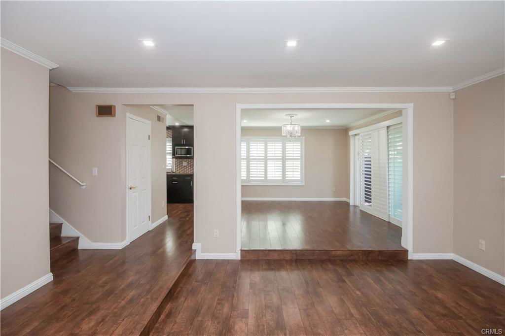
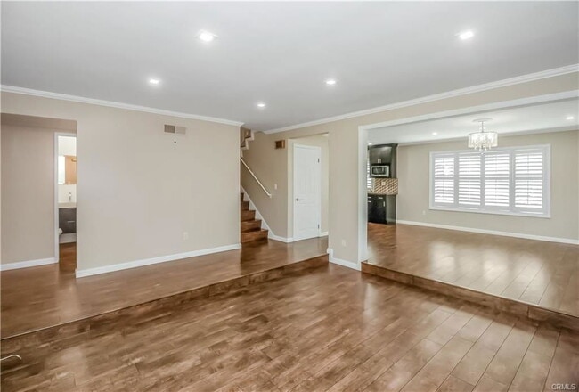
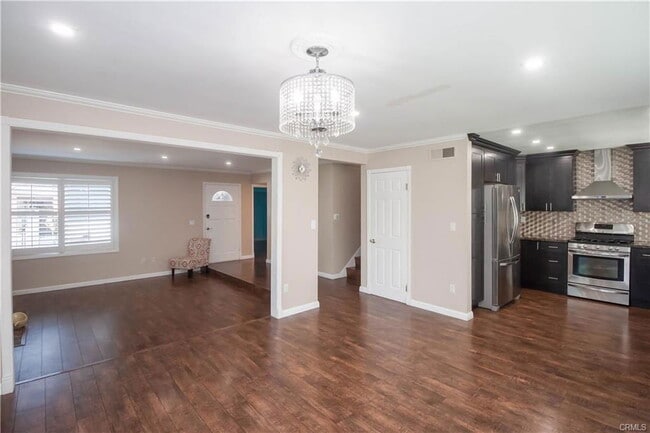
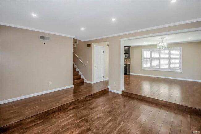
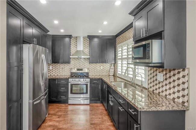
- Highly upgraded, 4 bed/ 2.5 bath home in Cypress Village community with downstairs bedroom & 1/2 bath** Remodeled open kitchen w/ backsplash, Hooded vent, New Cabinet**Inside laundry room**Alexa/Google home LED Dimmable ceiling lights in all bedrooms and living rooms**Water proof LED lights in bathrooms**Preinstalled Electric car charger in Garage**Pavers in patio**Corner lot with ample street parking**Key pad/keyless locks on all doors**Easy access to Garage from room**Newly renovated bathrooms with rain shower**Preinstalled TV mount for TV in master bedroom**Shutters in all rooms**Easy to maintain patio including Grill**Multiple swimming Pools, club houses & Tennis courts in the community. Close to freeways, grocery, etc etc... Listing provided by: Shefa Aggarwal of Kesav Realty LA State License 1913270 Listing posted by Orange County [SYNDID 4146607 12152025]
11378 Nashawena Ct is a house located in Orange County and the 90630 ZIP Code. This area is served by the Garden Grove Unified attendance zone.
* Price shown is base rent. Excludes user-selected optional fees and variable or usage-based fees and required charges due at or prior to move-in or at move-out. Price, availability, fees, and any applicable rent special are subject to change without notice.
* Square footage definitions vary. Displayed square footage is approximate.
Contact
- Listed by Orange County
- Phone Number
- Contact
Location
Get Directions
California dreaming is pretty accurate when describing the city of Cypress. Its proximity to major cities and destinations makes it a premier location to settle down with your family! This tight-knit, urban community is filled with a variety of single-family homes and apartments for rent, and the school system is well-respected. The Cypress School District thrives in this city, along with Cypress College.
What are the conveniences that make this city so grand, you ask? Cypress is situated just eight miles west of Anaheim, 25 miles southeast of Los Angeles, and about 15 miles northeast of Long Beach and other nearby sandy shorelines. And as for entertainment destinations, Los Alamitos Race Course is situated in the city, and just a few miles outside of town, you’ll discover Adventure City and the famous Knott’s Berry Farm, a theme park known for its fried chicken.
Learn more about living in Cypress
Education
| Colleges & Universities | Distance | ||
|---|---|---|---|
| Colleges & Universities | Distance | ||
| Drive: | 7 min | 3.3 mi | |
| Drive: | 11 min | 4.9 mi | |
| Drive: | 12 min | 8.0 mi | |
| Drive: | 17 min | 9.6 mi |
11378 Nashawena Ct is within 7 minutes or 3.3 miles from Cypress College. It is also near Golden West College and Cal State Long Beach.
Schools


Public Elementary School
Grades K-6
872 Students
Attendance Zone
Public Elementary School
Grades K-6
568 Students
Attendance Zone
Public Elementary School
Grades K-6
651 Students
Nearby
Public Middle School
Grades 7-8
629 Students
Attendance Zone
Public High School
Grades 9-12
1,648 Students
Attendance Zone
Private Elementary School
Grades PK-6
149 Students
Nearby
Private Elementary School
Grades K-6
Nearby
Private Elementary, Middle & High School
Grades K-12
Nearby
School data provided by
 The GreatSchools Rating helps parents compare schools within a state based on a variety of school quality indicators and provides a helpful picture of how effectively each school serves all of its students. Ratings are on a scale of 1 (below average) to 10 (above average) and can include test scores, college readiness, academic progress, advanced courses, equity, discipline and attendance data. We also advise parents to visit schools, consider other information on school performance and programs, and consider family needs as part of the school selection process.
View GreatSchools Rating Methodology
Data provided by GreatSchools.org © 2025. All rights reserved.
View GreatSchools Rating Methodology
Data provided by GreatSchools.org © 2025. All rights reserved.
Transportation options available in Cypress include Pacific Coast Highway Station, located 11.0 miles from 11378 Nashawena Ct. 11378 Nashawena Ct is near Long Beach (Daugherty Field), located 10.5 miles or 17 minutes away, and John Wayne/Orange County, located 15.2 miles or 21 minutes away.
| Transit / Subway | Distance | ||
|---|---|---|---|
| Transit / Subway | Distance | ||
|
|
Drive: | 21 min | 11.0 mi |
|
|
Drive: | 19 min | 11.7 mi |
|
|
Drive: | 17 min | 12.2 mi |
|
|
Drive: | 22 min | 12.3 mi |
| Commuter Rail | Distance | ||
|---|---|---|---|
| Commuter Rail | Distance | ||
|
|
Drive: | 14 min | 7.8 mi |
|
|
Drive: | 15 min | 8.7 mi |
| Drive: | 15 min | 8.8 mi | |
|
|
Drive: | 19 min | 10.8 mi |
|
|
Drive: | 19 min | 10.9 mi |
| Airports | Distance | ||
|---|---|---|---|
| Airports | Distance | ||
|
Long Beach (Daugherty Field)
|
Drive: | 17 min | 10.5 mi |
|
John Wayne/Orange County
|
Drive: | 21 min | 15.2 mi |
Time and distance from 11378 Nashawena Ct.
| Shopping Centers | Distance | ||
|---|---|---|---|
| Shopping Centers | Distance | ||
| Walk: | 14 min | 0.8 mi | |
| Walk: | 15 min | 0.8 mi | |
| Walk: | 19 min | 1.0 mi |
11378 Nashawena Ct has 3 shopping centers within 1.0 mile, which is about a 19-minute walk. The miles and minutes will be for the farthest away property.
| Parks and Recreation | Distance | ||
|---|---|---|---|
| Parks and Recreation | Distance | ||
|
El Dorado East Regional Park
|
Drive: | 12 min | 6.0 mi |
|
El Dorado Nature Center
|
Drive: | 10 min | 6.0 mi |
|
Earl Burns Miller Japanese Garden
|
Drive: | 14 min | 7.8 mi |
|
Los Cerritos Wetlands Trust
|
Drive: | 13 min | 8.2 mi |
|
Sunset Harbour
|
Drive: | 15 min | 8.7 mi |
11378 Nashawena Ct has 5 parks within 8.7 miles, including El Dorado Nature Center, El Dorado East Regional Park, and Earl Burns Miller Japanese Garden.
| Hospitals | Distance | ||
|---|---|---|---|
| Hospitals | Distance | ||
| Drive: | 6 min | 3.5 mi | |
| Drive: | 6 min | 3.5 mi | |
| Drive: | 9 min | 4.9 mi |
11378 Nashawena Ct has 3 hospitals within 4.9 miles, the nearest is West Anaheim Medical Center which is 3.5 miles away and a 6 minute drive.
| Military Bases | Distance | ||
|---|---|---|---|
| Military Bases | Distance | ||
| Drive: | 5 min | 1.9 mi |
11378 Nashawena Ct is 1.9 miles and a 5 minute drive from Los Alamitos Army Airfield.
You May Also Like
Similar Rentals Nearby


What Are Walk Score®, Transit Score®, and Bike Score® Ratings?
Walk Score® measures the walkability of any address. Transit Score® measures access to public transit. Bike Score® measures the bikeability of any address.
What is a Sound Score Rating?
A Sound Score Rating aggregates noise caused by vehicle traffic, airplane traffic and local sources

11378 Nashawena Ct
Cypress, CA 90630