
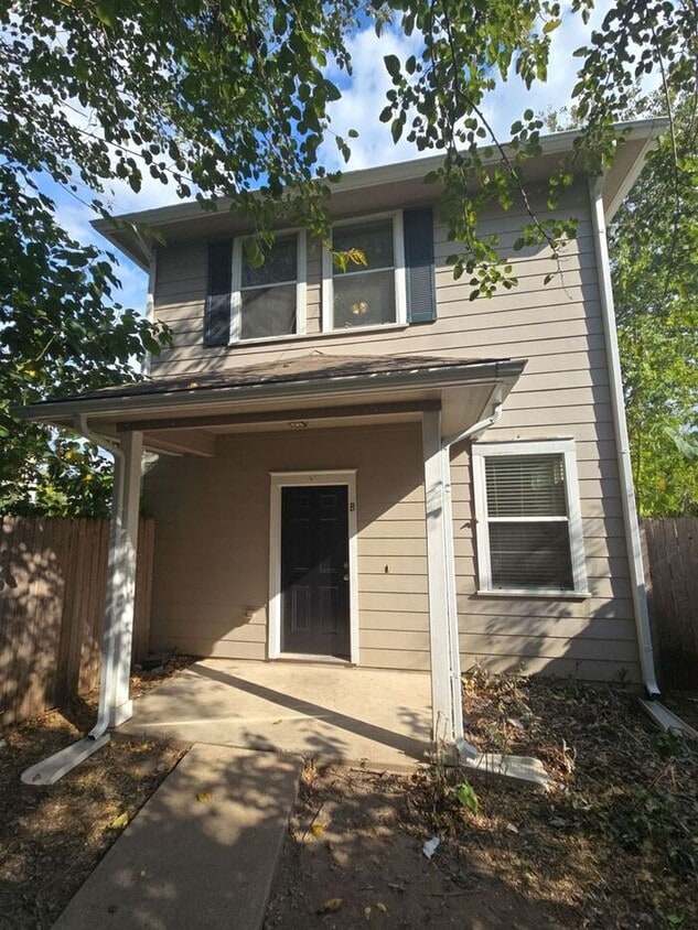
1125 Map St
Austin, TX 78721
-
Bedrooms
2
-
Bathrooms
1
-
Square Feet
760 sq ft
-
Available
Available Now

About This Home
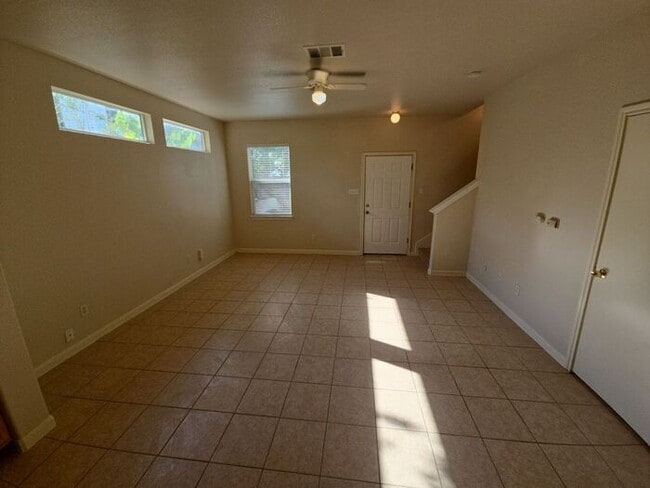
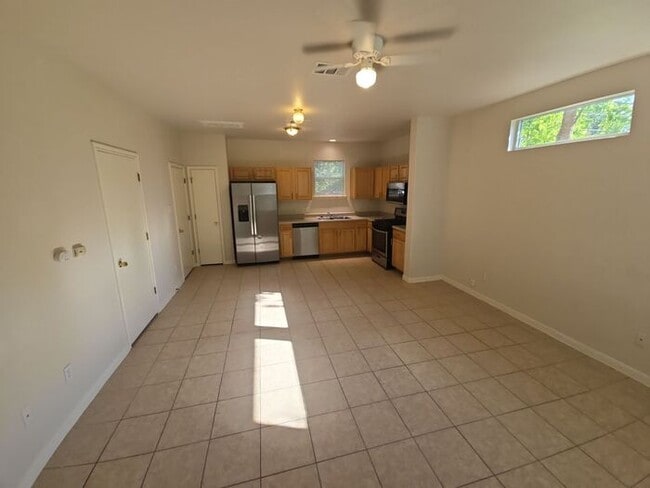
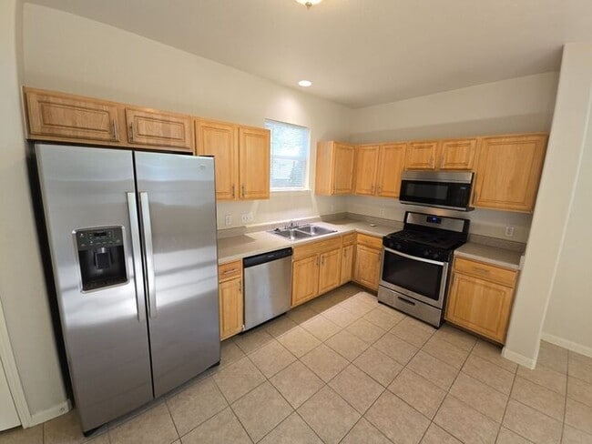
Stylish and comfortable 2-bedroom, 1-bath single-family home located in one of Austin’s most convenient and vibrant neighborhoods. This home features an open layout with tile and luxury vinyl plank flooring throughout, offering both durability and modern appeal. The kitchen is equipped with stainless steel appliances and plenty of storage, while large windows fill the home with natural light, creating a bright and airy atmosphere. Enjoy the convenience of off-street parking and easy access to nearby parks, restaurants, and downtown Austin. **Don’t miss the opportunity to live in this updated, move-in-ready East Austin gem — schedule a tour today!** Security Deposit - One Months Rent Utility Activation Fee - $50 Move In Fee - $15 Non Refundable Pet Fee - $300 Pet Rent - $50 This property allows self guided viewing without an appointment. Contact for details.
1125 Map St is a house located in Travis County and the 78721 ZIP Code. This area is served by the Austin Independent attendance zone.
Contact
- Phone Number
- Website View Property Website
- Contact
-
Source

East MLK is a quaint, historic neighborhood just four miles east of downtown Austin and eight miles north of the Austin-Bergstrom International Airport. With such luxuries in close proximity, East MLK residents have easy access to lively downtown streets and international travel.
The Austin Independent School District offers public schools like Norman Elementary School, along with community parks and open green space. On its way to becoming a wonderful recreational space for Austin residents with a master plan in progress, Little Walnut Creek Greenbelt covers 200 acres of undeveloped space in this residential neighborhood.
Residents appreciate the abundance of local restaurants in and around East MLK. Be sure to try Contigo, modeled after the owners’ family’s Texas ranch. This incredible restaurant has a covered patio and full bar that flows into outdoor ranch-style seating.
Learn more about living in East MLK| Colleges & Universities | Distance | ||
|---|---|---|---|
| Colleges & Universities | Distance | ||
| Drive: | 3 min | 1.3 mi | |
| Drive: | 7 min | 3.4 mi | |
| Drive: | 6 min | 3.4 mi | |
| Drive: | 8 min | 4.2 mi |


View GreatSchools Rating Methodology
Data provided by GreatSchools.org © 2025. All rights reserved.
Transportation options available in Austin include M L King Jr Station, located 1.9 miles from 1125 Map St. 1125 Map St is near Austin-Bergstrom International, located 9.7 miles or 19 minutes away.
| Transit / Subway | Distance | ||
|---|---|---|---|
| Transit / Subway | Distance | ||
| Drive: | 4 min | 1.9 mi | |
| Drive: | 5 min | 3.1 mi | |
| Drive: | 7 min | 3.8 mi | |
| Drive: | 8 min | 4.8 mi | |
| Drive: | 11 min | 5.8 mi |
| Commuter Rail | Distance | ||
|---|---|---|---|
| Commuter Rail | Distance | ||
|
|
Drive: | 10 min | 5.2 mi |
|
|
Drive: | 43 min | 33.0 mi |
|
|
Drive: | 42 min | 34.3 mi |
| Airports | Distance | ||
|---|---|---|---|
| Airports | Distance | ||
|
Austin-Bergstrom International
|
Drive: | 19 min | 9.7 mi |
Time and distance from 1125 Map St.
| Shopping Centers | Distance | ||
|---|---|---|---|
| Shopping Centers | Distance | ||
| Walk: | 13 min | 0.7 mi | |
| Walk: | 16 min | 0.8 mi | |
| Drive: | 3 min | 1.4 mi |
| Parks and Recreation | Distance | ||
|---|---|---|---|
| Parks and Recreation | Distance | ||
|
Boggy Creek Greenbelt
|
Drive: | 4 min | 1.6 mi |
|
Thinkery
|
Drive: | 5 min | 2.7 mi |
|
Texas Memorial Museum
|
Drive: | 7 min | 3.3 mi |
|
Lady Bird Lake
|
Drive: | 6 min | 3.3 mi |
|
Elisabet Ney Museum
|
Drive: | 8 min | 3.9 mi |
| Hospitals | Distance | ||
|---|---|---|---|
| Hospitals | Distance | ||
| Drive: | 6 min | 2.9 mi | |
| Drive: | 6 min | 3.0 mi | |
| Drive: | 7 min | 3.2 mi |
| Military Bases | Distance | ||
|---|---|---|---|
| Military Bases | Distance | ||
| Drive: | 85 min | 69.3 mi | |
| Drive: | 91 min | 73.7 mi |
1125 Map St Photos
Nearby Apartments
Within 50 Miles of 1125 Map St Austin, TX 78721
-
Banyan Everton Homes
2601 Crystal Bend Dr
Pflugerville, TX 78660
$2,338 - $2,787
3-4 Br 9.8 mi
-
YardHomes Trailside
16336 Cameron Road
Pflugerville, TX 78660
$2,010 - $2,575
2-3 Br 12.3 mi
-
The Village at Hutto Station
901-1000 County Road 138
Hutto, TX 78634
$1,825 - $2,619
2-3 Br 17.5 mi
-
The Oaks on Chisholm Trail
3000 Chisholm Trail Rd
Round Rock, TX 78681
$2,555 - $3,799
3-4 Br 18.8 mi
-
YardHomes® Meadow Lake
3350 College Park Dr
Round Rock, TX 78665
$1,965 - $2,710
2-3 Br 19.0 mi
-
SkyMor Carmel Creek
91 Hereford Loop
Hutto, TX 78634
$2,375 - $3,225
3-4 Br 19.6 mi
What Are Walk Score®, Transit Score®, and Bike Score® Ratings?
Walk Score® measures the walkability of any address. Transit Score® measures access to public transit. Bike Score® measures the bikeability of any address.
What is a Sound Score Rating?
A Sound Score Rating aggregates noise caused by vehicle traffic, airplane traffic and local sources
1125 Map St
Austin, TX 78721