

$1,895
/ Month
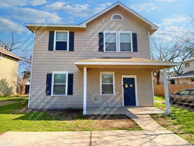
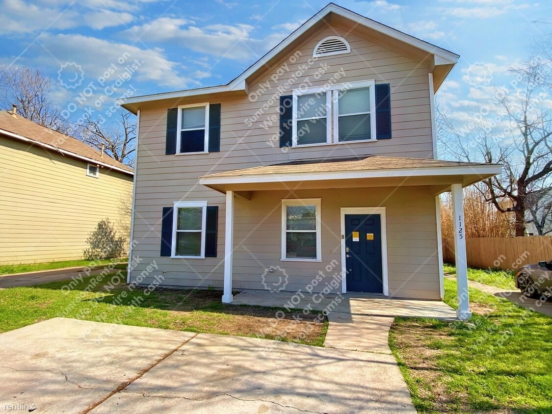
1125 Map St
Austin, TX 78721
2 Weeks Ago
Favorites
-
Bedrooms
4
-
Bathrooms
2
-
Square Feet
2,213 sq ft
1125 Map St

Favorites
About This Home
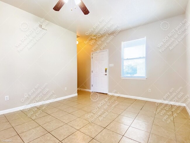
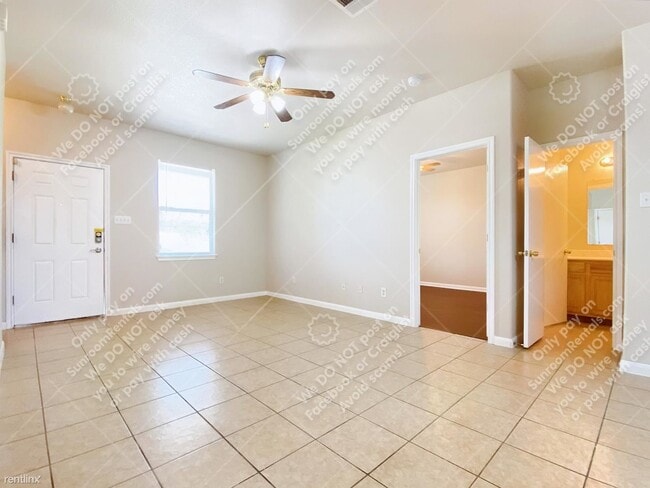
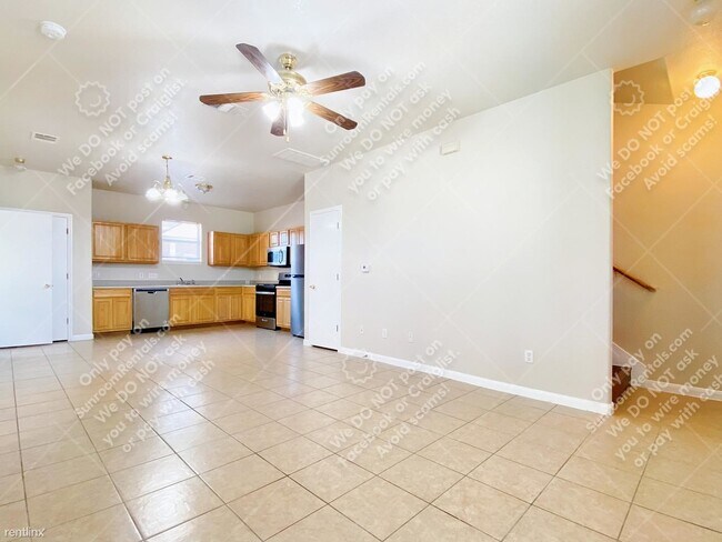
- Schedule your tour today to lease this incredible home on Austin’s east side! You will be in a quiet neighborhood that is a short drive away from the best local restaurants, bars, and breweries! This 4 bedroom, 2 bathroom home opens up into the main living and entertaining space. The floor plan flows into the L-shaped kitchen with tons of cabinets for storage space and sleek stainless steel appliances including a gas stove! Throughout the rest of the home, you will find 4 generously-sized bedrooms all equipped with ceilings fans and spacious closets. Other amenities in this home include the laundry room with washer/dryer hookups and the fenced private yard, perfect to be enjoyed with family or friends during the weekend! Come schedule a tour and apply today, this home will not be around for long! (RLNE8206302) Other Amenities: Unfurnished (Unfurnished), Parking (2 Spaces), Smoke Free (Smoke Free). Appliances: Dishwasher (Dishwasher), Air Conditioning (Air Conditioning), Refrigerator (Fridge), Washer & Dryer Hookup (wash/dry connections), Microwave (microwave). Pet policies: Small Dogs Allowed (Cats & Dogs), Cats Allowed (Cats & Dogs).
Unique Features
- Small Dogs Allowed - Cats & Dogs, Cats Allowed - Cats & Dogs
1125 Map St is a house located in Travis County and the 78721 ZIP Code.
* Price shown is base rent. Excludes user-selected optional fees and variable or usage-based fees and required charges due at or prior to move-in or at move-out. Price, availability, fees, and any applicable rent special are subject to change without notice.
* Square footage definitions vary. Displayed square footage is approximate.
House Features
- Air Conditioning
- Dishwasher
Fees and Policies
The fees below are based on community-supplied data and may exclude additional fees and utilities.
- Dogs Allowed
-
Fees not specified
- Cats Allowed
-
Fees not specified
Contact
- Listed by Sunroom Rentals
Location
Get Directions
Amenities
- Air Conditioning
- Dishwasher
- Small Dogs Allowed - Cats & Dogs, Cats Allowed - Cats & Dogs
East MLK is a quaint, historic neighborhood just four miles east of downtown Austin and eight miles north of the Austin-Bergstrom International Airport. With such luxuries in close proximity, East MLK residents have easy access to lively downtown streets and international travel.
The Austin Independent School District offers public schools like Norman Elementary School, along with community parks and open green space. On its way to becoming a wonderful recreational space for Austin residents with a master plan in progress, Little Walnut Creek Greenbelt covers 200 acres of undeveloped space in this residential neighborhood.
Residents appreciate the abundance of local restaurants in and around East MLK. Be sure to try Contigo, modeled after the owners’ family’s Texas ranch. This incredible restaurant has a covered patio and full bar that flows into outdoor ranch-style seating.
Learn more about living in East MLK
Education
| Colleges & Universities | Distance | ||
|---|---|---|---|
| Colleges & Universities | Distance | ||
| Drive: | 3 min | 1.3 mi | |
| Drive: | 7 min | 3.4 mi | |
| Drive: | 6 min | 3.4 mi | |
| Drive: | 8 min | 4.2 mi |
1125 Map St is within 3 minutes or 1.3 miles from Austin C.C., Eastview Campus. It is also near University of Texas at Austin and Austin C.C., Riverside Campus.
Transportation options available in Austin include M L King Jr Station, located 1.9 miles from 1125 Map St. 1125 Map St is near Austin-Bergstrom International, located 9.7 miles or 19 minutes away.
| Transit / Subway | Distance | ||
|---|---|---|---|
| Transit / Subway | Distance | ||
| Drive: | 4 min | 1.9 mi | |
| Drive: | 5 min | 3.1 mi | |
| Drive: | 7 min | 3.8 mi | |
| Drive: | 8 min | 4.8 mi | |
| Drive: | 11 min | 5.8 mi |
| Commuter Rail | Distance | ||
|---|---|---|---|
| Commuter Rail | Distance | ||
|
|
Drive: | 10 min | 5.2 mi |
|
|
Drive: | 43 min | 33.0 mi |
|
|
Drive: | 42 min | 34.3 mi |
| Airports | Distance | ||
|---|---|---|---|
| Airports | Distance | ||
|
Austin-Bergstrom International
|
Drive: | 19 min | 9.7 mi |
Time and distance from 1125 Map St.
| Shopping Centers | Distance | ||
|---|---|---|---|
| Shopping Centers | Distance | ||
| Walk: | 13 min | 0.7 mi | |
| Walk: | 16 min | 0.8 mi | |
| Drive: | 3 min | 1.4 mi |
1125 Map St has 3 shopping centers within 1.4 miles, which is about a 3-minute walk. The miles and minutes will be for the farthest away property.
| Parks and Recreation | Distance | ||
|---|---|---|---|
| Parks and Recreation | Distance | ||
|
Boggy Creek Greenbelt
|
Drive: | 4 min | 1.6 mi |
|
Thinkery
|
Drive: | 5 min | 2.7 mi |
|
Texas Memorial Museum
|
Drive: | 7 min | 3.3 mi |
|
Lady Bird Lake
|
Drive: | 6 min | 3.3 mi |
|
Elisabet Ney Museum
|
Drive: | 8 min | 3.9 mi |
1125 Map St has 5 parks within 3.9 miles, including Boggy Creek Greenbelt, Thinkery, and Texas Memorial Museum.
| Hospitals | Distance | ||
|---|---|---|---|
| Hospitals | Distance | ||
| Drive: | 6 min | 2.9 mi | |
| Drive: | 6 min | 3.0 mi | |
| Drive: | 7 min | 3.2 mi |
1125 Map St has 3 hospitals within 3.2 miles, the nearest is Dell Children's Medical Center of Central Texas which is 2.9 miles away and a 6 minute drive.
| Military Bases | Distance | ||
|---|---|---|---|
| Military Bases | Distance | ||
| Drive: | 85 min | 69.3 mi | |
| Drive: | 91 min | 73.7 mi |
1125 Map St is 69.3 miles from Randolph Air Force Base, and is convenient to other military bases, including Fort Hood.
You May Also Like
Similar Rentals Nearby
-
-

-

-

-

-
-
-
1 / 23

-
-


What Are Walk Score®, Transit Score®, and Bike Score® Ratings?
Walk Score® measures the walkability of any address. Transit Score® measures access to public transit. Bike Score® measures the bikeability of any address.
What is a Sound Score Rating?
A Sound Score Rating aggregates noise caused by vehicle traffic, airplane traffic and local sources
1125 Map St
Austin, TX 78721