
$2,650 / Month
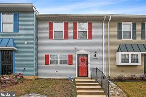
1106 Castlehaven Ct
Capitol Heights, MD 20743
Today
Favorites
703-599-6057
-
Bedrooms
3
-
Bathrooms
2.5
-
Square Feet
--
-
Available
Available Now
Highlights
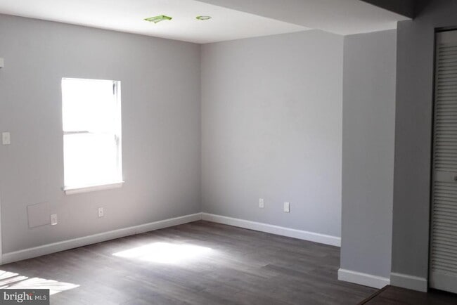
- Open Floorplan
- Colonial Architecture
- Community Basketball Court
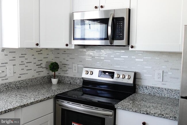
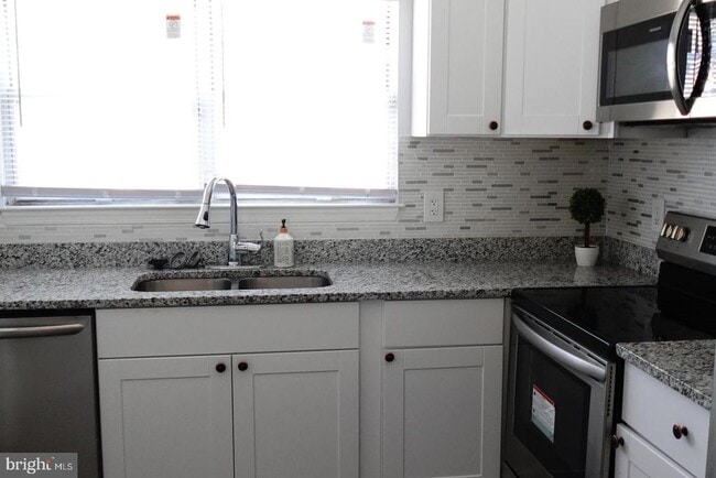
- Stainless Steel Appliances
- Double Pane Windows
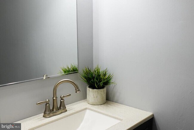
- Bathtub with Shower
1106 Castlehaven Ct

Favorites
About This Home
Available Now
Look no further than this beautifully renovated 3-bedroom, 2.5-bathroom townhome with a contemporary flair! This home boasts a brand-new roof, gleaming floors, new carpet and pads with underlays, fresh paint, 6-panel doors, beautifully tiled bathrooms, new electrical and plumbing fixtures, and a cozy master suite. The kitchen features brand-new granite countertops and stainless-steel appliances. Enjoy outdoor living and entertainment in the large, fenced backyard. This townhome is located in a great community with numerous amenities. Don't wait, schedule your showing today!
1106 Castlehaven Ct is a townhome located in Prince George's County and the 20743 ZIP Code. This area is served by the Prince George's County Public Schools attendance zone.
* Price shown is base rent and may not include non-optional fees and utilities.
Price, availability, fees, and any applicable rent special are subject to change without notice.
* Square footage definitions vary. Displayed square footage is approximate.
Home Details
Home Type
Interior Unit Townhome
Year Built
Built in 1986
Accessible Home Design
Level Entry For Accessibility
Bedrooms and Bathrooms
Bathtub with Shower
2.5 Bathrooms
3 Bedrooms
Eco-Friendly Details
Energy-Efficient Appliances
Flooring
Carpet
Laminate
Home Design
Colonial Architecture
Asphalt Roof
Concrete Perimeter Foundation
Frame Construction
Home Security
Storm Doors
Interior Spaces
Open Floorplan
Double Pane Windows
Sliding Doors
Ceiling Fan
Dining Area
Window Screens
1,200 Sq Ft Home
Property has 2 Levels
Window Treatments
Kitchen
Stainless Steel Appliances
Built-In Microwave
Dishwasher
Self-Cleaning Oven
Disposal
Listing and Financial Details
Security Deposit $2,650
Requires 1 Month of Rent Paid Up Front
12-Month Min and 24-Month Max Lease Term
Available 7/1/25
$50 Application Fee
Assessor Parcel Number 17182025369
Tenant pays for electricity, cable TV
Rent includes lawn service
No Smoking Allowed
Coming Soon on 6/1/25
Residential Lease
Lot Details
1,500 Sq Ft Lot
Property is in excellent condition
Utilities
Central Air
Heat Pump System
Electric Water Heater
Vented Exhaust Fan
Community Details
Overview
London Woods Subdivision
Pet Policy
No Pets Allowed
Recreation
Community Basketball Court
Community Playground
Contact
- Listed by Afarin Kovach | Fairfax Realty of Tysons
- Phone Number
- Contact
-
Source
 Bright MLS, Inc.
Copyright © 2025 Bright MLS, Inc.
Location
Get Directions
Amenities
- Dishwasher
Capitol Heights -- named for its location near Washington, DC -- provides the perfect location: near DC, near the Capital Beltway, and minutes away from FedEx Field, home of the NFL's Washington Football Team. It is also close to the Anacostia River, the United States National Arboretum, and Joint Base Anacostia-Bolling. Nearby Fort Circle Park provides Capitol Heights residents with 10 miles of hiking trails -- it is also a popular concert venue and is home to Fort Dupont Ice Rink.
Capitol Heights is a terrific location for your DC-area apartment, only about seven miles southeast of downtown. Hop on the Metro at the Capitol Heights Metro Station for a fast, car-free commute. Despite being so close to the historic sites of DC, Capitol Heights was a rural area with no paved roads or streetlights. In 1910, the 200 residents in the area named their town "Capitol Heights," but it wasn't until 1980 and the arrival of the Metro Blue Line that the town began to grow.
Learn more about living in Capitol Heights
Education
| Colleges & Universities | Distance | ||
|---|---|---|---|
| Colleges & Universities | Distance | ||
| Drive: | 11 min | 6.1 mi | |
| Drive: | 14 min | 6.6 mi | |
| Drive: | 12 min | 6.8 mi | |
| Drive: | 15 min | 7.5 mi |
1106 Castlehaven Ct is within 11 minutes or 6.1 miles from Prince George's Comm. Coll.. It is also near Univ. of Md. Univ. Coll. and Gallaudet University.
Schools


Public Elementary School
Grades PK-6
225 Students
Attendance Zone
Public Middle School
Grades 6-8
693 Students
Attendance Zone
Public High School
Grades 9-12
1,834 Students
Attendance Zone
Private Elementary & Middle School
Grades PK-8
Nearby
Private High School
Grades 9-12
858 Students
Nearby
School data provided by
 The GreatSchools Rating helps parents compare schools within a state based on a variety of school quality indicators and provides a helpful picture of how effectively each school serves all of its students. Ratings are on a scale of 1 (below average) to 10 (above average) and can include test scores, college readiness, academic progress, advanced courses, equity, discipline and attendance data. We also advise parents to visit schools, consider other information on school performance and programs, and consider family needs as part of the school selection process.
View GreatSchools Rating Methodology
Data provided by GreatSchools.org © 2025. All rights reserved.
View GreatSchools Rating Methodology
Data provided by GreatSchools.org © 2025. All rights reserved.
Transportation options available in Capitol Heights include Addison Road-Seat Pleasant, Blue/Silver Line Center Platform, located 1.6 miles from 1106 Castlehaven Ct. 1106 Castlehaven Ct is near Ronald Reagan Washington Ntl, located 12.0 miles or 24 minutes away, and Baltimore/Washington International Thurgood Marshall, located 30.6 miles or 47 minutes away.
| Transit / Subway | Distance | ||
|---|---|---|---|
| Transit / Subway | Distance | ||
| Drive: | 3 min | 1.6 mi | |
|
Capitol Heights, Blue/Silver Line Center Platform
|
Drive: | 5 min | 1.7 mi |
| Drive: | 7 min | 3.1 mi | |
| Drive: | 10 min | 3.8 mi | |
| Drive: | 9 min | 4.1 mi |
| Commuter Rail | Distance | ||
|---|---|---|---|
| Commuter Rail | Distance | ||
|
|
Drive: | 13 min | 6.8 mi |
|
|
Drive: | 14 min | 7.0 mi |
|
|
Drive: | 15 min | 7.2 mi |
|
|
Drive: | 17 min | 9.7 mi |
| Drive: | 17 min | 9.7 mi |
| Airports | Distance | ||
|---|---|---|---|
| Airports | Distance | ||
|
Ronald Reagan Washington Ntl
|
Drive: | 24 min | 12.0 mi |
|
Baltimore/Washington International Thurgood Marshall
|
Drive: | 47 min | 30.6 mi |
Time and distance from 1106 Castlehaven Ct.
| Shopping Centers | Distance | ||
|---|---|---|---|
| Shopping Centers | Distance | ||
| Drive: | 3 min | 1.2 mi | |
| Drive: | 4 min | 1.3 mi | |
| Drive: | 4 min | 1.5 mi |
1106 Castlehaven Ct has 3 shopping centers within 1.5 miles, which is about a 4-minute drive. The miles and minutes will be for the farthest away property.
| Parks and Recreation | Distance | ||
|---|---|---|---|
| Parks and Recreation | Distance | ||
|
Walker Mill Regional Park
|
Drive: | 7 min | 3.3 mi |
|
Fort Dupont Park
|
Drive: | 10 min | 3.9 mi |
|
Suitland Bog
|
Drive: | 9 min | 4.1 mi |
|
Kingman and Heritage Island Park
|
Drive: | 10 min | 4.8 mi |
|
National Arboretum
|
Drive: | 16 min | 8.0 mi |
1106 Castlehaven Ct has 5 parks within 8.0 miles, including Walker Mill Regional Park, Fort Dupont Park, and Suitland Bog.
| Hospitals | Distance | ||
|---|---|---|---|
| Hospitals | Distance | ||
| Drive: | 12 min | 5.7 mi | |
| Drive: | 15 min | 6.5 mi | |
| Drive: | 15 min | 6.7 mi |
1106 Castlehaven Ct has 3 hospitals within 6.7 miles, the nearest is University of Maryland Prince George's Hospital Center which is 5.7 miles away and a 12 minute drive.
| Military Bases | Distance | ||
|---|---|---|---|
| Military Bases | Distance | ||
| Drive: | 14 min | 6.7 mi | |
| Drive: | 15 min | 6.8 mi |
1106 Castlehaven Ct is 6.7 miles from Andrews Airforce Base, and is convenient to other military bases, including Washington Navy Yard.
You May Also Like
Similar Rentals Nearby


What Are Walk Score®, Transit Score®, and Bike Score® Ratings?
Walk Score® measures the walkability of any address. Transit Score® measures access to public transit. Bike Score® measures the bikeability of any address.
What is a Sound Score Rating?
A Sound Score Rating aggregates noise caused by vehicle traffic, airplane traffic and local sources
1106 Castlehaven Ct
Capitol Heights, MD 20743