$3,495 / Month
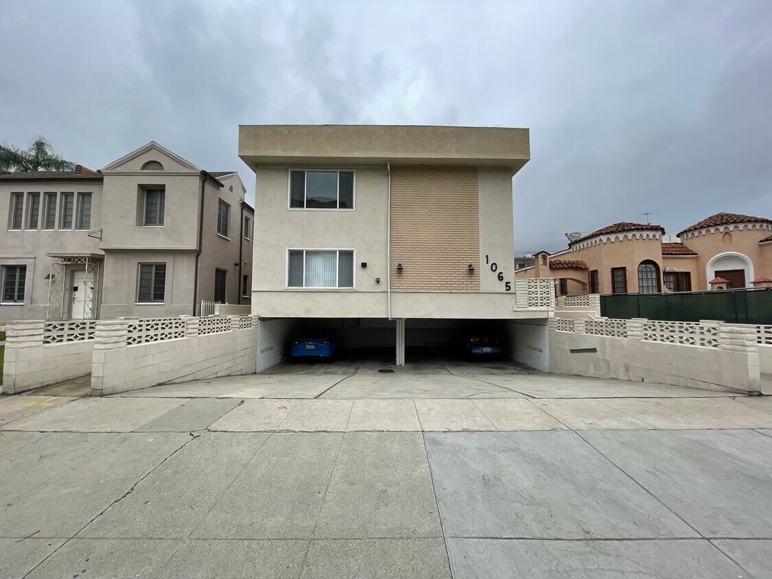
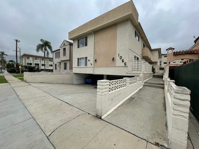
1065 S Holt Ave Unit 1
Los Angeles, CA 90035
2 Weeks Ago
Favorites
1065 S Holt Ave Unit 1

Favorites
Check Back Soon for Upcoming Availability
| Beds | Baths | Average SF |
|---|---|---|
| 3 Bedrooms 3 Bedrooms 3 Br | 2 Baths 2 Baths 2 Ba | 1,200 SF |
Fees and Policies
The fees below are based on community-supplied data and may exclude additional fees and utilities.
- Parking
-
Covered--
Details
Utilities Included
-
Water
Property Information
-
4 units
About This Property
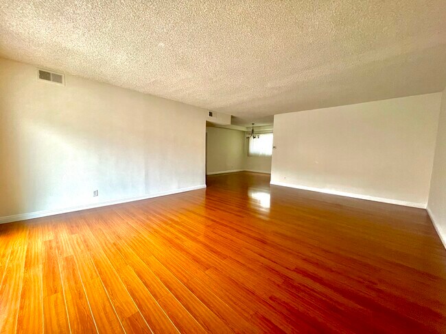
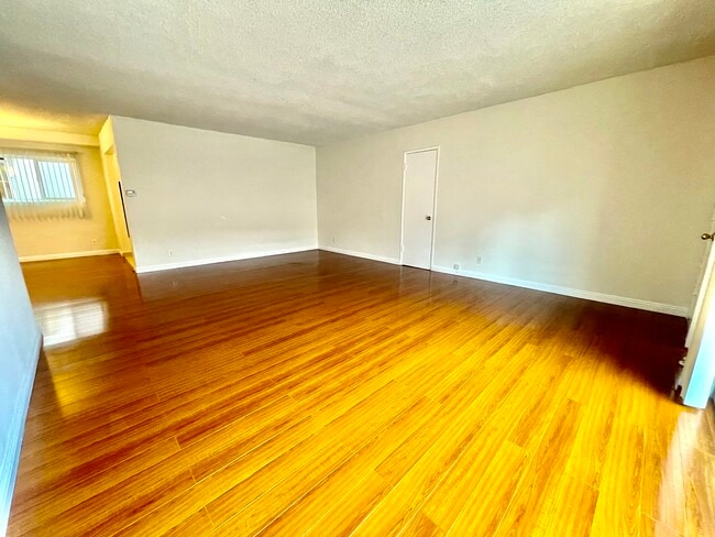
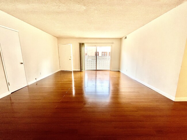
Don't miss your chance to call this large three-bedroom, two-bathroom, and approximately 1,200 sq. ft. unit your next home. This bright, large, lower front unit in a four-unit building is very conveniently located on a quiet residential street between Olympic Blvd. and Pico Blvd. and between Robertson and La Cienega Blvd. and is close to transportation, shopping, and parks and minutes from Cedars Sinai Hospital. The unit has hardwood-like floors in living and dining rooms and professionally cleaned carpeting in bedrooms. The unit comes equipped with a stove/oven, refrigerator, and dishwasher. There is laundry available on-site. The living/dining area opens to one large patio and one bedroom opens to a 2nd large patio. The unit also has central cooling and heating and comes with tandem parking spaces in a covered carport.
1065 S Holt Ave is an apartment community located in Los Angeles County and the 90035 ZIP Code.
Apartment Features
Air Conditioning
Dishwasher
Refrigerator
Smoke Free
- Air Conditioning
- Heating
- Smoke Free
- Dishwasher
- Oven
- Refrigerator
- Dining Room
- Laundry Facilities
- Patio
Location
Get Directions
Pico-Robertson is a popular Los Angeles neighborhood situated directly south of Beverly Hills and east of Century City. Despite its location in the heart of glittery West Los Angeles near the Miracle Mile, Beverlywood, Carthay, and Cheviot Hills, Pico-Robertson is much more low-key. You won't find trendy hotspots and wild nightlife in Pico-Robertson, but you will find a strong sense of community and a quiet setting.
Pico-Robertson offers a unique collection of delis, bakeries, and more. It is named for the intersection of Pico Boulevard and Robertson Boulevard, and that's where you'll find the majority of the neighborhood's shops, restaurants, and cafes.
Learn more about living in Pico-RobertsonBelow are rent ranges for similar nearby apartments
| Beds | Average Size | Lowest | Typical | Premium |
|---|---|---|---|---|
| Studio Studio Studio | 587 Sq Ft | $1,800 | $2,252 | $3,000 |
| 1 Bed 1 Bed 1 Bed | 982-986 Sq Ft | $1,875 | $2,623 | $4,000 |
| 2 Beds 2 Beds 2 Beds | 1298-1300 Sq Ft | $2,510 | $3,612 | $7,000 |
| 3 Beds 3 Beds 3 Beds | 1565 Sq Ft | $3,200 | $4,815 | $8,650 |
| 4 Beds 4 Beds 4 Beds | 3095 Sq Ft | $7,500 | $10,065 | $12,495 |
Amenities
- Air Conditioning
- Heating
- Smoke Free
- Dishwasher
- Oven
- Refrigerator
- Dining Room
- Laundry Facilities
- Patio
Expenses
Utilities Included
Water
Included
Education
| Colleges & Universities | Distance | ||
|---|---|---|---|
| Colleges & Universities | Distance | ||
| Drive: | 12 min | 4.9 mi | |
| Drive: | 12 min | 5.4 mi | |
| Drive: | 10 min | 5.5 mi | |
| Drive: | 11 min | 5.9 mi |
1065 S Holt Ave Unit 1 is within 12 minutes or 4.9 miles from West Los Angeles College. It is also near UCLA and Musicians Institute.
Transportation options available in Los Angeles include La Cienega/Jefferson, located 2.5 miles from 1065 S Holt Ave Unit 1. 1065 S Holt Ave Unit 1 is near Los Angeles International, located 9.5 miles or 19 minutes away, and Bob Hope, located 13.9 miles or 26 minutes away.
| Transit / Subway | Distance | ||
|---|---|---|---|
| Transit / Subway | Distance | ||
|
|
Drive: | 5 min | 2.5 mi |
|
|
Drive: | 6 min | 2.5 mi |
|
|
Drive: | 6 min | 3.3 mi |
|
|
Drive: | 8 min | 4.0 mi |
|
|
Drive: | 9 min | 4.0 mi |
| Commuter Rail | Distance | ||
|---|---|---|---|
| Commuter Rail | Distance | ||
|
|
Drive: | 17 min | 9.1 mi |
|
|
Drive: | 19 min | 9.4 mi |
|
|
Drive: | 20 min | 11.5 mi |
|
|
Drive: | 23 min | 11.8 mi |
|
|
Drive: | 25 min | 12.7 mi |
| Airports | Distance | ||
|---|---|---|---|
| Airports | Distance | ||
|
Los Angeles International
|
Drive: | 19 min | 9.5 mi |
|
Bob Hope
|
Drive: | 26 min | 13.9 mi |
Time and distance from 1065 S Holt Ave Unit 1.
| Shopping Centers | Distance | ||
|---|---|---|---|
| Shopping Centers | Distance | ||
| Walk: | 4 min | 0.2 mi | |
| Walk: | 8 min | 0.5 mi | |
| Walk: | 8 min | 0.5 mi |
1065 S Holt Ave Unit 1 has 3 shopping centers within 0.5 mile, which is about a 8-minute walk. The miles and minutes will be for the farthest away property.
| Parks and Recreation | Distance | ||
|---|---|---|---|
| Parks and Recreation | Distance | ||
|
Zimmer Children's Museum
|
Drive: | 3 min | 1.2 mi |
|
La Brea Tar Pits
|
Drive: | 3 min | 1.7 mi |
|
Virginia Robinson Gardens
|
Drive: | 9 min | 3.7 mi |
|
Kenneth Hahn State Recreation Area
|
Drive: | 12 min | 4.5 mi |
|
Mathias Botanical Garden
|
Drive: | 11 min | 4.9 mi |
1065 S Holt Ave Unit 1 has 5 parks within 4.9 miles, including Zimmer Children's Museum, La Brea Tar Pits, and Virginia Robinson Gardens.
| Hospitals | Distance | ||
|---|---|---|---|
| Hospitals | Distance | ||
| Walk: | 20 min | 1.1 mi | |
| Drive: | 2 min | 1.2 mi | |
| Drive: | 3 min | 1.5 mi |
1065 S Holt Ave Unit 1 has 3 hospitals within 1.5 miles, the nearest is Docs Surgical Hospital which is 1.1 miles away and a 20 minute walk.
| Military Bases | Distance | ||
|---|---|---|---|
| Military Bases | Distance | ||
| Drive: | 19 min | 11.1 mi |
1065 S Holt Ave Unit 1 is 11.1 miles and a 19 minute drive from Los Angeles Air Force Base.
You May Also Like
Similar Rentals Nearby


 - AVA Burbank")
What Are Walk Score®, Transit Score®, and Bike Score® Ratings?
Walk Score® measures the walkability of any address. Transit Score® measures access to public transit. Bike Score® measures the bikeability of any address.
What is a Sound Score Rating?
A Sound Score Rating aggregates noise caused by vehicle traffic, airplane traffic and local sources

1065 S Holt Ave
Los Angeles, CA 90035