
$1,488
Total Monthly Price
1062 S Corning St Unit Upper
Los Angeles, CA 90035
2 Weeks Ago
|
Edit
Favorites
1062 S Corning St Unit Upper

Favorites
Check Back Soon for Upcoming Availability
| Beds | Baths | Average SF |
|---|---|---|
| Studio Studio 0 Br | 1 Bath 1 Bath 1 Ba | 350 SF |
Fees and Policies
The fees listed below are community-provided and may exclude utilities or add-ons. All payments are made directly to the property and are non-refundable unless otherwise specified.
- Parking
-
Covered--
Details
Utilities Included
-
Gas
-
Water
-
Electricity
-
Heat
-
Trash Removal
-
Sewer
-
Air Conditioning
Lease Options
-
6 Month
Property Information
-
2 units
About This Property
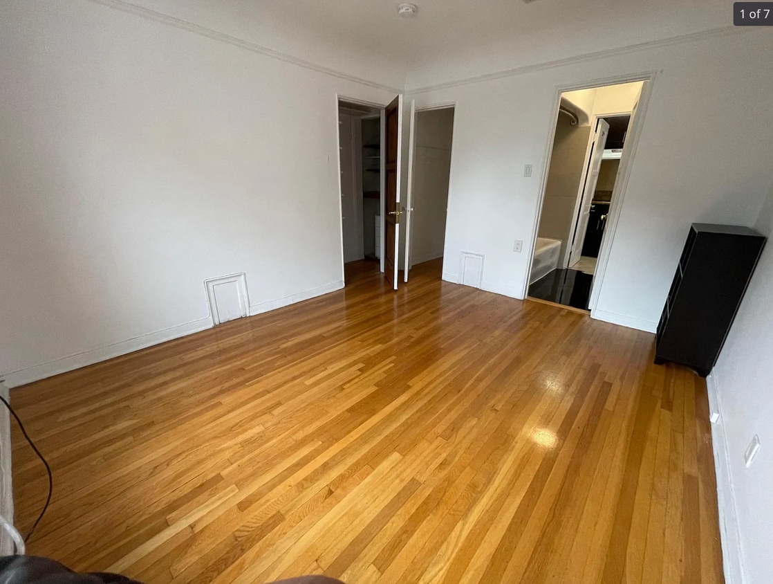
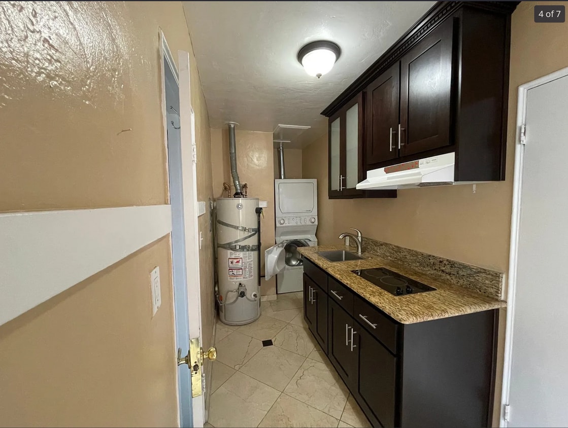
studio 1 Bed 1 Bath room kitchen Hardwood Tile floors all utilities paid Close to all markets and schools, The Grove The Beverly Hills park, Beverly Hills motion picture Museum, Rodeo drive century city mall, beverly center, lacienega park, westwood, West Hollywood Melrose Melrose place west los angeles beverly hills, beverly wood, ucla, usc, santa monica college ceders Sinai Nearby City Names/nicknames: Century City, Beverlywood, West Hollywood, Beverly Crest, Hollywood Hills West, Hollywood, Fairfax, Beverly Grove, Carthay, Pico-Robertson, Westwood, Rancho Park Zip Codes: 90035, 90210, 90211, 90212, 90024, 90048, 90067, 90077, 90069 Streets: Elm, Doheny, Roxbury, Bedford, Beverly, Rodeo, Sunset, Robertson, Avenue of the Stars, Beverly Glen, La Cienega, San Vicente, Melrose, Palm, Crescent, Oakhurst, Santa Monica Blvd, Maple, Rexford, Whitworth, Greenfield, La Peer, Crescent, Oakhurst Attractions: Beverly Center, Rodeo Drive, Sunset Strip, Fox Studios, Lawrys, Fogo De Chao, Westside Pavilion, Westfield Shoppingtown Century City, Houstons, shops at Robertson, Cedars Sinai
1062 S Corning St is an apartment community located in Los Angeles County and the 90035 ZIP Code.
Apartment Features
Washer/Dryer
Air Conditioning
Dishwasher
Hardwood Floors
- Washer/Dryer
- Air Conditioning
- Heating
- Smoke Free
- Cable Ready
- Dishwasher
- Disposal
- Kitchen
- Hardwood Floors
- Tile Floors
- Gated
- Yard
1062 S Corning St,
Los Angeles,
CA
90035
Pico-Robertson is a popular Los Angeles neighborhood situated directly south of Beverly Hills and east of Century City. Despite its location in the heart of glittery West Los Angeles near the Miracle Mile, Beverlywood, Carthay, and Cheviot Hills, Pico-Robertson is much more low-key. You won't find trendy hotspots and wild nightlife in Pico-Robertson, but you will find a strong sense of community and a quiet setting.
Pico-Robertson offers a unique collection of delis, bakeries, and more. It is named for the intersection of Pico Boulevard and Robertson Boulevard, and that's where you'll find the majority of the neighborhood's shops, restaurants, and cafes.
Learn more about living in Pico-RobertsonBelow are rent ranges for similar nearby apartments
| Beds | Average Size | Lowest | Typical | Premium |
|---|---|---|---|---|
| Studio Studio Studio | 522 Sq Ft | $1,675 | $2,166 | $2,500 |
| 1 Bed 1 Bed 1 Bed | 761 Sq Ft | $1,725 | $2,376 | $3,475 |
| 2 Beds 2 Beds 2 Beds | 1168-1175 Sq Ft | $2,290 | $3,467 | $6,800 |
| 3 Beds 3 Beds 3 Beds | 1484 Sq Ft | $3,595 | $4,745 | $7,800 |
| 4 Beds 4 Beds 4 Beds | 2896 Sq Ft | $6,095 | $10,341 | $17,000 |
Amenities
- Washer/Dryer
- Air Conditioning
- Heating
- Smoke Free
- Cable Ready
- Dishwasher
- Disposal
- Kitchen
- Hardwood Floors
- Tile Floors
- Gated
- Yard
Expenses
Utilities Included
Gas, Water, Electricity, Heat, Trash Removal, Sewer, Air Conditioning
Included
Education
| Colleges & Universities | Distance | ||
|---|---|---|---|
| Colleges & Universities | Distance | ||
| Drive: | 12 min | 4.9 mi | |
| Drive: | 12 min | 5.4 mi | |
| Drive: | 10 min | 5.4 mi | |
| Drive: | 11 min | 5.8 mi |
1062 S Corning St Unit Upper is within 12 minutes or 4.9 miles from West Los Angeles College. It is also near UCLA and Musicians Institute.
Transportation options available in Los Angeles include La Cienega/Jefferson, located 2.4 miles from 1062 S Corning St Unit Upper. 1062 S Corning St Unit Upper is near Los Angeles International, located 9.5 miles or 19 minutes away, and Bob Hope, located 13.8 miles or 26 minutes away.
| Transit / Subway | Distance | ||
|---|---|---|---|
| Transit / Subway | Distance | ||
|
|
Drive: | 5 min | 2.4 mi |
|
|
Drive: | 6 min | 2.5 mi |
|
|
Drive: | 6 min | 3.3 mi |
|
|
Drive: | 9 min | 4.0 mi |
|
|
Drive: | 8 min | 4.0 mi |
| Commuter Rail | Distance | ||
|---|---|---|---|
| Commuter Rail | Distance | ||
|
|
Drive: | 17 min | 9.0 mi |
|
|
Drive: | 19 min | 9.3 mi |
|
|
Drive: | 20 min | 11.4 mi |
|
|
Drive: | 23 min | 11.7 mi |
|
|
Drive: | 24 min | 12.6 mi |
| Airports | Distance | ||
|---|---|---|---|
| Airports | Distance | ||
|
Los Angeles International
|
Drive: | 19 min | 9.5 mi |
|
Bob Hope
|
Drive: | 26 min | 13.8 mi |
Walkability Near 1062 S Corning St Los Angeles, CA 90035
Getting Around
 What do Walkability, Transit, Drivability, and Bikeability mean?
Walkability measures the walking distance to day-to-day needs.
Transit measures access to public transportation.
Drivability measures congestion, parking availability, and access to major roads.
Bikeability measures the suitability for cycling.
How It Works
What do Walkability, Transit, Drivability, and Bikeability mean?
Walkability measures the walking distance to day-to-day needs.
Transit measures access to public transportation.
Drivability measures congestion, parking availability, and access to major roads.
Bikeability measures the suitability for cycling.
How It Works
Very Walkable
Walkability
80
/ 100
Good Public Transit
Transit
70
/ 100
Moderately Drivable
Drivability
60
/ 100
Fairly Bikeable
Bikeability
50
/ 100
Scores provided by
-
Soundscore™
-
/ 100
Traffic
-Airport
-Businesses
-Scores provided by
HowLoud What is a Sound Score Rating? A Sound Score Rating aggregates noise caused by vehicle traffic, airplane traffic and local sources. How It WorksTime and distance from 1062 S Corning St Unit Upper.
| Shopping Centers | Distance | ||
|---|---|---|---|
| Shopping Centers | Distance | ||
| Walk: | 2 min | 0.1 mi | |
| Walk: | 8 min | 0.4 mi | |
| Walk: | 9 min | 0.5 mi |
1062 S Corning St Unit Upper has 3 shopping centers within 0.5 mile, which is about a 9-minute walk. The miles and minutes will be for the farthest away property.
| Parks and Recreation | Distance | ||
|---|---|---|---|
| Parks and Recreation | Distance | ||
|
Zimmer Children's Museum
|
Drive: | 3 min | 1.1 mi |
|
La Brea Tar Pits
|
Drive: | 3 min | 1.6 mi |
|
Virginia Robinson Gardens
|
Drive: | 9 min | 3.7 mi |
|
Kenneth Hahn State Recreation Area
|
Drive: | 12 min | 4.5 mi |
|
Runyon Canyon
|
Drive: | 11 min | 4.7 mi |
1062 S Corning St Unit Upper has 5 parks within 4.7 miles, including Zimmer Children's Museum, La Brea Tar Pits, and Virginia Robinson Gardens.
| Hospitals | Distance | ||
|---|---|---|---|
| Hospitals | Distance | ||
| Walk: | 19 min | 1.0 mi | |
| Drive: | 2 min | 1.1 mi | |
| Drive: | 3 min | 1.4 mi |
1062 S Corning St Unit Upper has 3 hospitals within 1.4 miles, the nearest is Docs Surgical Hospital which is 1.0 mile away and a 19 minute walk.
| Military Bases | Distance | ||
|---|---|---|---|
| Military Bases | Distance | ||
| Drive: | 19 min | 11.1 mi |
1062 S Corning St Unit Upper is 11.1 miles and a 19 minute drive from Los Angeles Air Force Base.
You May Also Like
Similar Rentals Nearby
-
-
-
-
-
-
-
1 Bed$2,851+2 Beds$3,468+Total Monthly PriceTotal Monthly Price NewPrices include base rent and required monthly fees of $15. Variable costs based on usage may apply.Base Rent:1 Bed$2,836+2 Beds$3,453+2 Months Free
Pets Allowed In Unit Washer & Dryer Maintenance on site Heat Controlled Access Elevator
-
-
-


What Are Walk Score®, Transit Score®, and Bike Score® Ratings?
Walk Score® measures the walkability of any address. Transit Score® measures access to public transit. Bike Score® measures the bikeability of any address.
What is a Sound Score Rating?
A Sound Score Rating aggregates noise caused by vehicle traffic, airplane traffic and local sources.

1062 S Corning St
Los Angeles, CA 90035