
$6,250 / Month
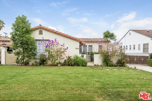
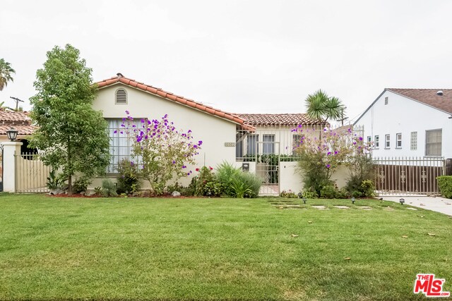
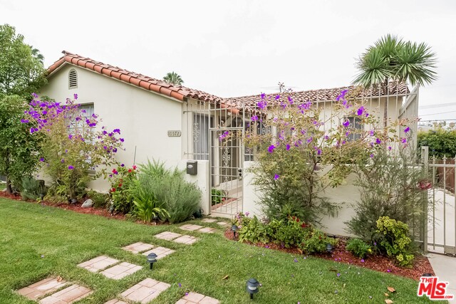
10572 Kinnard Ave
Los Angeles, CA 90024
2 Weeks Ago
Favorites
10572 Kinnard Ave

Favorites
Check Back Soon for Upcoming Availability
| Beds | Baths | Average SF |
|---|---|---|
| 3 Bedrooms 3 Bedrooms 3 Br | 2 Baths 2 Baths 2 Ba | 1,712 SF |
Fees and Policies
The fees below are based on community-supplied data and may exclude additional fees and utilities.
Pet policies are negotiable.
About This Property
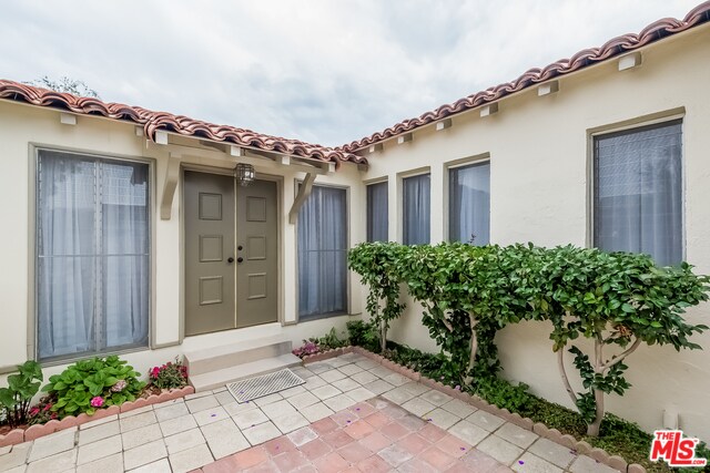
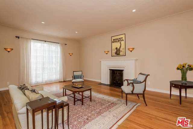
Beautiful 3 bed, 2 bath single family Spanish in prime Westwood. Bright and light with hardwood floors throughout. Kitchen with tiled countertops and backsplash, sunny breakfast room / office, large living room with a fireplace, formal dining room and spacious enclosed sun porch, Large backyard, child friendly. Detached 2 car garage and plenty of storage. Ideally located near Beverly Hills, Century City Mall, houses of worship, UCLA and renowned Fairburn Avenue Elementary School.
10572 Kinnard Ave is a house located in Los Angeles County and the 90024 ZIP Code. This area is served by the Los Angeles Unified attendance zone.
House Features
Washer/Dryer
Dishwasher
Washer/Dryer Hookup
Hardwood Floors
- Washer/Dryer
- Washer/Dryer Hookup
- Dishwasher
- Microwave
- Refrigerator
- Hardwood Floors
- Dining Room
Location
Get Directions
Home to UCLA, Westwood lies on the west side of the city and is considered to be one of Los Angeles’ premier neighborhoods. Bordered by Beverly Hills, Bel Air, Brentwood, and Century City, multimillion dollar homes populate the landscape and students pay a premium to rent near campus.
The university itself serves as a major cultural center for the community, including on-campus attractions (such as the Fowler Museum and the Franklin D. Murphy Sculpture Garden) and university-affiliated venues off-campus (The Hammer Museum, the Geffen Playhouse), as well as the presence of thousands of students and faculty members throughout the neighborhood.
Directly south of campus, Westwood Village is a historic shopping district that features blocks of restaurants and businesses catering to both students and the neighborhood’s larger workforce. Many prominent corporations and law offices are found along Wilshire Boulevard, one of the busiest east-west transit corridors across the city.
Learn more about living in WestwoodBelow are rent ranges for similar nearby apartments
| Beds | Average Size | Lowest | Typical | Premium |
|---|---|---|---|---|
| Studio Studio Studio | 361-366 Sq Ft | $1,295 | $2,258 | $3,495 |
| 1 Bed 1 Bed 1 Bed | 688-691 Sq Ft | $955 | $3,226 | $8,750 |
| 2 Beds 2 Beds 2 Beds | 1110-1116 Sq Ft | $995 | $4,539 | $12,900 |
| 3 Beds 3 Beds 3 Beds | 1782-1796 Sq Ft | $1,280 | $7,685 | $27,000 |
| 4 Beds 4 Beds 4 Beds | 1455-1551 Sq Ft | $1,000 | $4,996 | $67,000 |
Amenities
- Washer/Dryer
- Washer/Dryer Hookup
- Dishwasher
- Microwave
- Refrigerator
- Hardwood Floors
- Dining Room
Education
| Colleges & Universities | Distance | ||
|---|---|---|---|
| Colleges & Universities | Distance | ||
| Drive: | 5 min | 1.8 mi | |
| Drive: | 9 min | 3.3 mi | |
| Drive: | 10 min | 4.1 mi | |
| Drive: | 10 min | 4.1 mi |
10572 Kinnard Ave is within 5 minutes or 1.8 miles from UCLA. It is also near Santa Monica Coll., Academy and The Art Inst., Los Angeles.
Schools


Public Elementary School
Grades K-5
393 Students
Nearby
Public Elementary School
Grades K-5
436 Students
Attendance Zone
Charter Middle School
Grades 6-8
492 Students
Attendance Zone
Charter High School
Grades 9-12
1,338 Students
Attendance Zone
Private Elementary, Middle & High School
Grades PK-12
Nearby
Private Elementary & Middle School
Grades PK-8
452 Students
Nearby
Private Elementary & Middle School
Grades K-8
Nearby
Private Elementary School
Grades K-1
Nearby
School data provided by
 The GreatSchools Rating helps parents compare schools within a state based on a variety of school quality indicators and provides a helpful picture of how effectively each school serves all of its students. Ratings are on a scale of 1 (below average) to 10 (above average) and can include test scores, college readiness, academic progress, advanced courses, equity, discipline and attendance data. We also advise parents to visit schools, consider other information on school performance and programs, and consider family needs as part of the school selection process.
View GreatSchools Rating Methodology
Data provided by GreatSchools.org © 2025. All rights reserved.
View GreatSchools Rating Methodology
Data provided by GreatSchools.org © 2025. All rights reserved.
Transportation options available in Los Angeles include Westwood/Rancho Park, located 2.0 miles from 10572 Kinnard Ave. 10572 Kinnard Ave is near Los Angeles International, located 10.5 miles or 18 minutes away, and Bob Hope, located 18.9 miles or 29 minutes away.
| Transit / Subway | Distance | ||
|---|---|---|---|
| Transit / Subway | Distance | ||
|
|
Drive: | 5 min | 2.0 mi |
| Drive: | 5 min | 2.1 mi | |
|
|
Drive: | 8 min | 3.0 mi |
|
|
Drive: | 8 min | 3.8 mi |
|
|
Drive: | 10 min | 5.0 mi |
| Commuter Rail | Distance | ||
|---|---|---|---|
| Commuter Rail | Distance | ||
|
|
Drive: | 26 min | 13.1 mi |
|
|
Drive: | 27 min | 13.5 mi |
|
|
Drive: | 23 min | 13.9 mi |
|
|
Drive: | 22 min | 15.3 mi |
|
|
Drive: | 29 min | 18.9 mi |
| Airports | Distance | ||
|---|---|---|---|
| Airports | Distance | ||
|
Los Angeles International
|
Drive: | 18 min | 10.5 mi |
|
Bob Hope
|
Drive: | 29 min | 18.9 mi |
Time and distance from 10572 Kinnard Ave.
| Shopping Centers | Distance | ||
|---|---|---|---|
| Shopping Centers | Distance | ||
| Walk: | 16 min | 0.9 mi | |
| Walk: | 16 min | 0.9 mi | |
| Walk: | 16 min | 0.9 mi |
10572 Kinnard Ave has 3 shopping centers within 0.9 mile, which is about a 16-minute walk. The miles and minutes will be for the farthest away property.
| Parks and Recreation | Distance | ||
|---|---|---|---|
| Parks and Recreation | Distance | ||
|
Mathias Botanical Garden
|
Drive: | 4 min | 1.3 mi |
|
Hannah Carter Japanese Garden
|
Drive: | 7 min | 2.4 mi |
|
Virginia Robinson Gardens
|
Drive: | 9 min | 3.2 mi |
|
Zimmer Children's Museum
|
Drive: | 9 min | 4.3 mi |
|
Franklin Canyon Park
|
Drive: | 18 min | 5.7 mi |
10572 Kinnard Ave has 5 parks within 5.7 miles, including Mathias Botanical Garden, Hannah Carter Japanese Garden, and Virginia Robinson Gardens.
| Hospitals | Distance | ||
|---|---|---|---|
| Hospitals | Distance | ||
| Drive: | 5 min | 1.7 mi | |
| Drive: | 5 min | 1.7 mi | |
| Drive: | 9 min | 3.6 mi |
10572 Kinnard Ave has 3 hospitals within 3.6 miles, the nearest is Ronald Reagan UCLA Medical Center which is 1.7 miles away and a 5 minute drive.
| Military Bases | Distance | ||
|---|---|---|---|
| Military Bases | Distance | ||
| Drive: | 19 min | 13.1 mi |
10572 Kinnard Ave is 13.1 miles and a 19 minute drive from Los Angeles Air Force Base.
You May Also Like
Similar Rentals Nearby


What Are Walk Score®, Transit Score®, and Bike Score® Ratings?
Walk Score® measures the walkability of any address. Transit Score® measures access to public transit. Bike Score® measures the bikeability of any address.
What is a Sound Score Rating?
A Sound Score Rating aggregates noise caused by vehicle traffic, airplane traffic and local sources

10572 Kinnard Ave
Los Angeles, CA 90024