
Venue Residences
3688 Overland Ave,
Los Angeles, CA 90034
$3,550 - $4,795
1-2 Beds
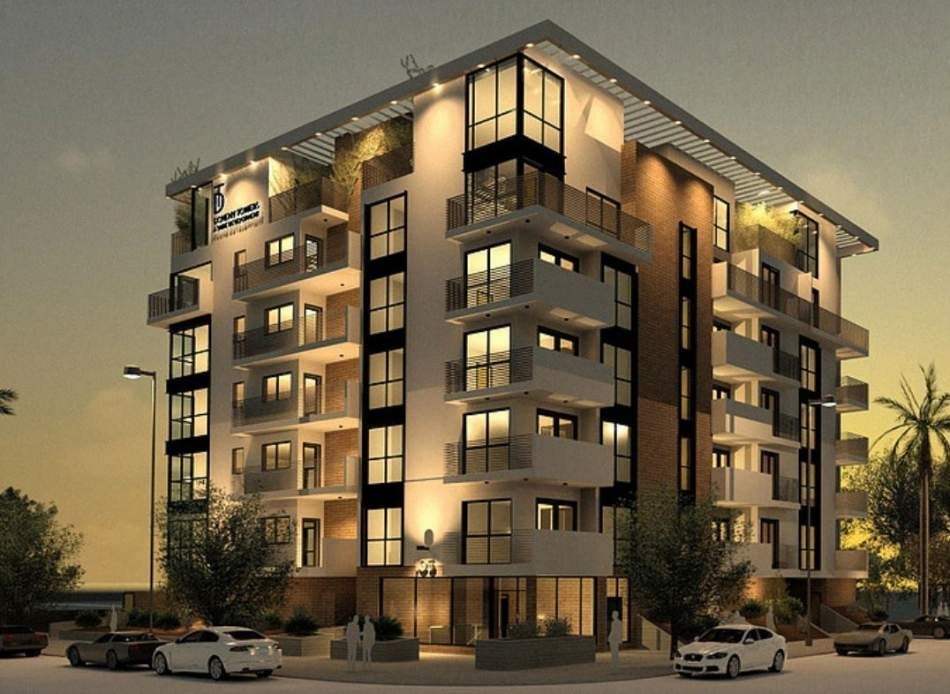
THE DOHENY offers the ultimate luxury & comfort experience. It is located on one of the most safest & luxurious neighborhood of Los Angeles. We are located near all the high-end & trendy shopping, close by to all the dining districts, and walking distance from beauty & fitness. Doheny is adjacent to Beverly Hills, Robertson Boulevard, 3rd Street, & Melrose Avenue. It is also near by to the famous Sunset Strip, Fairfax Avenue, as well as popular retail and entertainment complexes like the Beverly Center, Century City, the Farmer's Market, and The Grove. Doheny’s location provides a comfortable & leisure lifestyle.
105 Doheny is an apartment community located in Los Angeles County and the 90048 ZIP Code. This area is served by the Los Angeles Unified Rocp School District attendance zone.
Unique Features
Fitness Center
Elevator
Controlled Access
Recycling
Washer/Dryer
Air Conditioning
Dishwasher
Hardwood Floors
Island Kitchen
Microwave
Refrigerator
Wi-Fi
Los Angeles sprawls across nearly 500 square miles between the Pacific Ocean and the San Gabriel Mountains, making it one of the few places where you can surf in the morning and hike through chaparral-covered hills by afternoon. Sunshine, open-air farmers markets, and a food scene that pulls from dozens of culinary traditions are a staple of living in the city.
Neighborhoods each have a distinct personality surrounding a particular focus, whether it be culture or nature. Westwood keeps residents close to entertainment at the University of Southern California and the Hammer Museum's rotating art exhibitions. Koreatown is a cultural and food destination, known for authentic restaurants and shops paired with a bustling street energy and nightlife.
The city overflows with iconic landmarks, from natural to man-made. Griffith Park, one of the largest urban parks in the country, offers hiking trails, sweeping skyline views, and the iconic Griffith Observatory.
Learn more about living in Los AngelesCompare neighborhood and city base rent averages by bedroom.
| Beverly Grove | Los Angeles, CA | |
|---|---|---|
| Studio | $2,539 | $1,712 |
| 1 Bedroom | $2,785 | $2,178 |
| 2 Bedrooms | $3,815 | $3,017 |
| 3 Bedrooms | $5,218 | $4,255 |
| Colleges & Universities | Distance | ||
|---|---|---|---|
| Colleges & Universities | Distance | ||
| Drive: | 9 min | 4.4 mi | |
| Drive: | 10 min | 4.4 mi | |
| Drive: | 10 min | 4.8 mi | |
| Drive: | 15 min | 6.1 mi |


Transportation options available in Los Angeles include Culver City, located 3.9 miles from 105 Doheny. 105 Doheny is near Los Angeles International, located 11.7 miles or 23 minutes away, and Bob Hope, located 12.7 miles or 24 minutes away.
| Transit / Subway | Distance | ||
|---|---|---|---|
| Transit / Subway | Distance | ||
|
|
Drive: | 9 min | 3.9 mi |
|
|
Drive: | 9 min | 4.0 mi |
|
|
Drive: | 9 min | 4.3 mi |
|
|
Drive: | 10 min | 4.3 mi |
|
|
Drive: | 9 min | 4.6 mi |
| Commuter Rail | Distance | ||
|---|---|---|---|
| Commuter Rail | Distance | ||
|
|
Drive: | 18 min | 9.5 mi |
|
|
Drive: | 20 min | 9.7 mi |
|
|
Drive: | 20 min | 10.3 mi |
|
|
Drive: | 21 min | 10.7 mi |
|
|
Drive: | 23 min | 11.6 mi |
| Airports | Distance | ||
|---|---|---|---|
| Airports | Distance | ||
|
Los Angeles International
|
Drive: | 23 min | 11.7 mi |
|
Bob Hope
|
Drive: | 24 min | 12.7 mi |
Scores provided by
Traffic
BusyAirport
CalmBusinesses
ActiveScores provided by
HowLoud What is a Sound Score Rating? A Sound Score Rating aggregates noise caused by vehicle traffic, airplane traffic and local sources. How It WorksTime and distance from 105 Doheny.
| Shopping Centers | Distance | ||
|---|---|---|---|
| Shopping Centers | Distance | ||
| Walk: | 12 min | 0.7 mi | |
| Walk: | 14 min | 0.7 mi | |
| Walk: | 18 min | 0.9 mi |
| Parks and Recreation | Distance | ||
|---|---|---|---|
| Parks and Recreation | Distance | ||
|
Zimmer Children's Museum
|
Drive: | 4 min | 2.0 mi |
|
Virginia Robinson Gardens
|
Drive: | 6 min | 2.5 mi |
|
La Brea Tar Pits
|
Drive: | 5 min | 2.6 mi |
|
Mathias Botanical Garden
|
Drive: | 9 min | 4.0 mi |
|
Franklin Canyon Park
|
Drive: | 15 min | 4.7 mi |
| Hospitals | Distance | ||
|---|---|---|---|
| Hospitals | Distance | ||
| Walk: | 11 min | 0.6 mi | |
| Drive: | 4 min | 2.4 mi | |
| Drive: | 5 min | 2.5 mi |
| Military Bases | Distance | ||
|---|---|---|---|
| Military Bases | Distance | ||
| Drive: | 22 min | 13.3 mi |
Pets Allowed In Unit Washer & Dryer Maintenance on site Heat Controlled Access Elevator
What Are Walk Score®, Transit Score®, and Bike Score® Ratings?
Walk Score® measures the walkability of any address. Transit Score® measures access to public transit. Bike Score® measures the bikeability of any address.
What is a Sound Score Rating?
A Sound Score Rating aggregates noise caused by vehicle traffic, airplane traffic and local sources.

105 S Doheny Dr
Los Angeles, CA 90048


