$2,200
Total Monthly Price
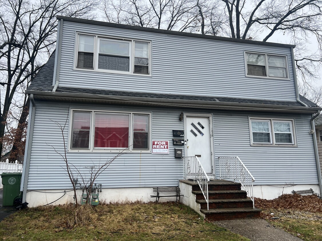
1029 Harrison Ave Unit # 1
Roselle, NJ 07203
Today
|
Edit
Favorites
908-259-6508
-
Bedrooms
2
-
Bathrooms
1
-
Square Feet
800 sq ft
-
Available
Available Now
Highlights
- Hardwood Floors
- Yard
1029 Harrison Ave

Favorites
About This Home
12 Month Lease,
$2,200 deposit,
Available Now
Living room, big eat in kitchen. close to all transportation to NYC. Free street parking
2 bedrooms, 1 bath BIG Eat in Kitchen and HUGE living room
1029 Harrison Ave is a house located in Union County and the 07203 ZIP Code.
* Price shown is total price based on community-supplied monthly required fees. Excludes user-selected optional fees and variable or usage-based fees and required charges due at or prior to move-in or at move-out. Price, availability, fees, and any applicable rent special are subject to change without notice.
* Square footage definitions vary. Displayed square footage is approximate.
House Features
Hardwood Floors
Heating
Eat-in Kitchen
Dining Room
- Heating
- Eat-in Kitchen
- Kitchen
- Hardwood Floors
- Dining Room
- Yard
Fees and Policies
The fees listed below are community-provided and may exclude utilities or add-ons. All payments are made directly to the property and are non-refundable unless otherwise specified.
- Parking
-
Other--
Details
Utilities Included
-
Water
-
Heat
-
Sewer
Property Information
-
3 units
Contact
- Phone Number
Location
Get Directions
Ideally located about 10 miles southwest of Newark and 18 miles from New York City, Roselle is a cozy borough for those looking for a quieter place to call home. First settled around 1664, Roselle was settled by farmers looking for better farmland. It was part of the first New Jersey settlement called Elizabethtown. The borough was officially incorporated in 1894 as Roselle.
Today, this terrific community features beautiful parks and great shopping. Warinanco Park, the borough's largest park, offers ball fields, a running track, a playground, pedal boats, an ice skating rink, a fitness trail, a bicycle path, fishing, a spray pool, tennis courts, picnic areas, and shuffleboard. Roselle's tree-lined streets are mainly residential, with a shopping district located between Westfield Avenue and West 1st Avenue.
Learn more about living in Roselle
Education
| Colleges & Universities | Distance | ||
|---|---|---|---|
| Colleges & Universities | Distance | ||
| Drive: | 6 min | 2.4 mi | |
| Drive: | 8 min | 3.2 mi | |
| Drive: | 15 min | 5.1 mi | |
| Drive: | 16 min | 7.5 mi |
1029 Harrison Ave is within 6 minutes or 2.4 miles from Union County Coll., Elizabeth. It is also near Kean University and Union County College, Cranford.
Transportation options available in Roselle include Military Park, located 8.9 miles from 1029 Harrison Ave. 1029 Harrison Ave is near Newark Liberty International, located 9.5 miles or 17 minutes away, and LaGuardia, located 27.3 miles or 50 minutes away.
| Transit / Subway | Distance | ||
|---|---|---|---|
| Transit / Subway | Distance | ||
|
|
Drive: | 15 min | 8.9 mi |
| Drive: | 17 min | 9.1 mi | |
|
|
Drive: | 15 min | 9.5 mi |
|
|
Drive: | 16 min | 10.0 mi |
|
|
Drive: | 19 min | 10.3 mi |
| Commuter Rail | Distance | ||
|---|---|---|---|
| Commuter Rail | Distance | ||
|
|
Drive: | 7 min | 2.1 mi |
|
|
Drive: | 5 min | 2.3 mi |
|
|
Drive: | 7 min | 2.5 mi |
|
|
Drive: | 8 min | 3.6 mi |
|
|
Drive: | 10 min | 3.8 mi |
| Airports | Distance | ||
|---|---|---|---|
| Airports | Distance | ||
|
Newark Liberty International
|
Drive: | 17 min | 9.5 mi |
|
LaGuardia
|
Drive: | 50 min | 27.3 mi |
Time and distance from 1029 Harrison Ave.
| Shopping Centers | Distance | ||
|---|---|---|---|
| Shopping Centers | Distance | ||
| Walk: | 12 min | 0.6 mi | |
| Walk: | 18 min | 1.0 mi | |
| Drive: | 4 min | 1.2 mi |
1029 Harrison Ave has 3 shopping centers within 1.2 miles, which is about a 4-minute drive. The miles and minutes will be for the farthest away property.
| Parks and Recreation | Distance | ||
|---|---|---|---|
| Parks and Recreation | Distance | ||
|
Hawk Rise Sanctuary
|
Drive: | 12 min | 4.7 mi |
|
William Miller Sperry Observatory
|
Drive: | 13 min | 5.0 mi |
|
Staten Island Industrial Park
|
Drive: | 13 min | 6.5 mi |
|
William T. Davis Wildlife Refuge
|
Drive: | 15 min | 7.7 mi |
|
Liberty State Park
|
Drive: | 15 min | 7.8 mi |
1029 Harrison Ave has 5 parks within 7.8 miles, including William Miller Sperry Observatory, Hawk Rise Sanctuary, and Staten Island Industrial Park.
| Hospitals | Distance | ||
|---|---|---|---|
| Hospitals | Distance | ||
| Drive: | 6 min | 2.2 mi | |
| Drive: | 9 min | 3.8 mi | |
| Drive: | 13 min | 6.0 mi |
1029 Harrison Ave has 3 hospitals within 6.0 miles, the nearest is Trinitas Regional Medical Center which is 2.2 miles away and a 6 minute drive.
| Military Bases | Distance | ||
|---|---|---|---|
| Military Bases | Distance | ||
| Drive: | 18 min | 6.8 mi | |
| Drive: | 16 min | 7.2 mi | |
| Drive: | 22 min | 13.3 mi |
1029 Harrison Ave has 3 military bases within 13.3 miles, the nearest is Tamdques Reservation which is 6.8 miles away and a 18 minute drive.
Amenities
- Heating
- Eat-in Kitchen
- Kitchen
- Hardwood Floors
- Dining Room
- Yard
1029 Harrison Ave Photos
How do I access Social Services in New Jersey?
Statewide service is free, confidential, multilingual and always open. Three easy ways to reach Social Services in NJ: Dial 2-1-1; text your zip code to 898-211; or chat at https://www.nj211.org
What Are Walk Score®, Transit Score®, and Bike Score® Ratings?
Walk Score® measures the walkability of any address. Transit Score® measures access to public transit. Bike Score® measures the bikeability of any address.
What is a Sound Score Rating?
A Sound Score Rating aggregates noise caused by vehicle traffic, airplane traffic and local sources

1029 Harrison Ave
Roselle, NJ 07203