
$3,600
/ Month
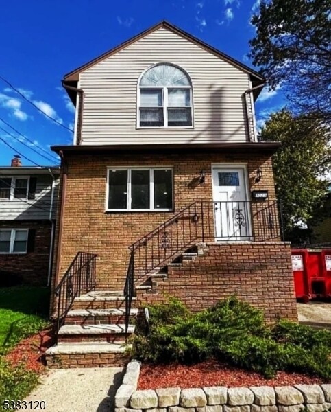
1029 Chandler Ave
Roselle, NJ 07203
1 Day Ago
|
Edit
Favorites
908-422-2844
-
Bedrooms
3
-
Bathrooms
2
-
Square Feet
--
-
Available
Available Now
Highlights
- Vaulted Ceiling
- Wood Flooring
- Formal Dining Room
- Skylights
- Shades
- Bathtub with Shower
1029 Chandler Ave

Favorites
About This Home
Available Now
Step into this beautifully renovated Roselle home with a large backyard perfect for gatherings. Upstairs you'll find three bedrooms, including a master with vaulted ceilings and oversized windows, plus a spacious full bath with walk-in shower. The main level features a bright living room, formal dining space, and a modern kitchen with brand-new stainless steel appliances and a breakfast bar, along with a full bath and plenty of storage. The basement is partly finished and includes a dedicated laundry area with washer/dryer. Ideally located near the Linden border, houses of worship, and shopping.
1029 Chandler Ave is a house located in Union County and the 07203 ZIP Code. This area is served by the Roselle Public attendance zone.
* Price shown is base rent. Excludes user-selected optional fees and variable or usage-based fees and required charges due at or prior to move-in or at move-out. Price, availability, fees, and any applicable rent special are subject to change without notice.
* Square footage definitions vary. Displayed square footage is approximate.
Home Details
Bedrooms and Bathrooms
Bathtub with Shower
Walk-in Shower
Primary bedroom located on second floor
2 Full Bathrooms
3 Bedrooms
Home Design
Tile
Home Security
Storm Doors
Carbon Monoxide Detectors
Fire and Smoke Detector
Interior Spaces
Vaulted Ceiling
Wood Flooring
Formal Dining Room
Skylights
Shades
Living Room
2-Story Property
Kitchen
Gas Oven or Range
Microwave
Dishwasher
Laundry
Laundry Room
Dryer
Washer
Listing and Financial Details
Assessor Parcel Number 2914-01208-0000-00015-0000-
Tenant pays for electric, gas, heat, hot water, maintenance-common area, maintenance-lawn
Lot Details
4,792 Sq Ft Lot
Outdoor Features
Storage Shed
Parking
Private Driveway
On-Street Parking
Off-Street Parking
2 Parking Spaces
Utilities
Central Air
Electric Baseboard Heater
Community Details
Fees and Policies
The fees below are based on community-supplied data and may exclude additional fees and utilities.
- Street Parking
Property Fee Disclaimer: Based on community-supplied data and independent market research. Subject to change without notice. May exclude fees for mandatory or optional services and usage-based utilities.
Contact
- Listed by JEFFREY BROOKMAN | GardenStateMLS#NJ
- Phone Number
- Contact
-
Source
Garden State Multiple Listing Service, LLC
Copyright © 2025 Garden State MLS, LLC. All rights reserved. All information provided by the listing agent/broker is deemed reliable but is not guaranteed and should be independently verified.
Location
Get Directions
Amenities
- Air Conditioning
- Tile Floors
Ideally located about 10 miles southwest of Newark and 18 miles from New York City, Roselle is a cozy borough for those looking for a quieter place to call home. First settled around 1664, Roselle was settled by farmers looking for better farmland. It was part of the first New Jersey settlement called Elizabethtown. The borough was officially incorporated in 1894 as Roselle.
Today, this terrific community features beautiful parks and great shopping. Warinanco Park, the borough's largest park, offers ball fields, a running track, a playground, pedal boats, an ice skating rink, a fitness trail, a bicycle path, fishing, a spray pool, tennis courts, picnic areas, and shuffleboard. Roselle's tree-lined streets are mainly residential, with a shopping district located between Westfield Avenue and West 1st Avenue.
Learn more about living in Roselle
Education
| Colleges & Universities | Distance | ||
|---|---|---|---|
| Colleges & Universities | Distance | ||
| Drive: | 7 min | 2.5 mi | |
| Drive: | 8 min | 3.3 mi | |
| Drive: | 15 min | 5.0 mi | |
| Drive: | 16 min | 7.6 mi |
1029 Chandler Ave is within 7 minutes or 2.5 miles from Union County Coll., Elizabeth. It is also near Kean University and Union County College, Cranford.
Schools


Public Elementary School
Grades PK-5
437 Students
Nearby
Public Elementary School
Grades 5-6
436 Students
Attendance Zone
Public Elementary School
Grades K
200 Students
Attendance Zone
Public Elementary School
Grades PK & 1-4
301 Students
Attendance Zone
Public Middle School
Grades 7-8
435 Students
Attendance Zone
Public High School
Grades 9-12
884 Students
Attendance Zone
Private Elementary & Middle School
Grades PK-8
199 Students
Nearby
Private Elementary School
Grades PK-6
Nearby
Private High School
Grades 9-12
354 Students
Nearby
School data provided by
 The GreatSchools Rating helps parents compare schools within a state based on a variety of school quality indicators and provides a helpful picture of how effectively each school serves all of its students. Ratings are on a scale of 1 (below average) to 10 (above average) and can include test scores, college readiness, academic progress, advanced courses, equity, discipline and attendance data. We also advise parents to visit schools, consider other information on school performance and programs, and consider family needs as part of the school selection process.
View GreatSchools Rating Methodology
Data provided by GreatSchools.org © 2025. All rights reserved.
View GreatSchools Rating Methodology
Data provided by GreatSchools.org © 2025. All rights reserved.
Transportation options available in Roselle include Military Park, located 9.0 miles from 1029 Chandler Ave. 1029 Chandler Ave is near Newark Liberty International, located 9.6 miles or 17 minutes away, and LaGuardia, located 27.4 miles or 51 minutes away.
| Transit / Subway | Distance | ||
|---|---|---|---|
| Transit / Subway | Distance | ||
|
|
Drive: | 15 min | 9.0 mi |
| Drive: | 18 min | 9.2 mi | |
|
|
Drive: | 16 min | 9.6 mi |
|
|
Drive: | 17 min | 10.1 mi |
|
|
Drive: | 19 min | 10.4 mi |
| Commuter Rail | Distance | ||
|---|---|---|---|
| Commuter Rail | Distance | ||
|
|
Drive: | 6 min | 1.9 mi |
|
|
Drive: | 5 min | 2.2 mi |
|
|
Drive: | 7 min | 2.6 mi |
|
|
Drive: | 10 min | 3.6 mi |
|
|
Drive: | 8 min | 3.7 mi |
| Airports | Distance | ||
|---|---|---|---|
| Airports | Distance | ||
|
Newark Liberty International
|
Drive: | 17 min | 9.6 mi |
|
LaGuardia
|
Drive: | 51 min | 27.4 mi |
Time and distance from 1029 Chandler Ave.
| Shopping Centers | Distance | ||
|---|---|---|---|
| Shopping Centers | Distance | ||
| Walk: | 14 min | 0.7 mi | |
| Drive: | 4 min | 1.2 mi | |
| Drive: | 5 min | 1.3 mi |
1029 Chandler Ave has 3 shopping centers within 1.3 miles, which is about a 5-minute walk. The miles and minutes will be for the farthest away property.
| Parks and Recreation | Distance | ||
|---|---|---|---|
| Parks and Recreation | Distance | ||
|
Hawk Rise Sanctuary
|
Drive: | 11 min | 4.6 mi |
|
William Miller Sperry Observatory
|
Drive: | 13 min | 4.8 mi |
|
Staten Island Industrial Park
|
Drive: | 13 min | 6.6 mi |
|
Liberty State Park
|
Drive: | 15 min | 7.3 mi |
|
William T. Davis Wildlife Refuge
|
Drive: | 15 min | 7.8 mi |
1029 Chandler Ave has 5 parks within 7.8 miles, including William Miller Sperry Observatory, Hawk Rise Sanctuary, and Staten Island Industrial Park.
| Hospitals | Distance | ||
|---|---|---|---|
| Hospitals | Distance | ||
| Drive: | 6 min | 2.3 mi | |
| Drive: | 9 min | 3.8 mi | |
| Drive: | 13 min | 6.1 mi |
1029 Chandler Ave has 3 hospitals within 6.1 miles, the nearest is Trinitas Regional Medical Center which is 2.3 miles away and a 6 minute drive.
| Military Bases | Distance | ||
|---|---|---|---|
| Military Bases | Distance | ||
| Drive: | 18 min | 6.7 mi | |
| Drive: | 15 min | 7.1 mi | |
| Drive: | 22 min | 13.4 mi |
1029 Chandler Ave has 3 military bases within 13.4 miles, the nearest is Tamdques Reservation which is 6.7 miles away and a 18 minute drive.
You May Also Like
How do I access Social Services in New Jersey?
Statewide service is free, confidential, multilingual and always open. Three easy ways to reach Social Services in NJ: Dial 2-1-1; text your zip code to 898-211; or chat at https://www.nj211.org
Similar Rentals Nearby


What Are Walk Score®, Transit Score®, and Bike Score® Ratings?
Walk Score® measures the walkability of any address. Transit Score® measures access to public transit. Bike Score® measures the bikeability of any address.
What is a Sound Score Rating?
A Sound Score Rating aggregates noise caused by vehicle traffic, airplane traffic and local sources

1029 Chandler Ave
Roselle, NJ 07203