
$3,900 / Month
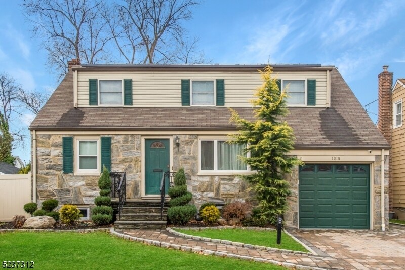
1018 Stone St
Union Township, NJ 07083
2 Weeks Ago
Favorites
1018 Stone St

Favorites
Check Back Soon for Upcoming Availability
| Beds | Baths | Average SF |
|---|---|---|
| 4 Bedrooms 4 Bedrooms 4 Br | 2 Baths 2 Baths 2 Ba | — |
Fees and Policies
The fees below are based on community-supplied data and may exclude additional fees and utilities.
- Parking
-
Garage--
About This Property
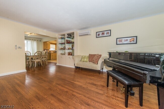
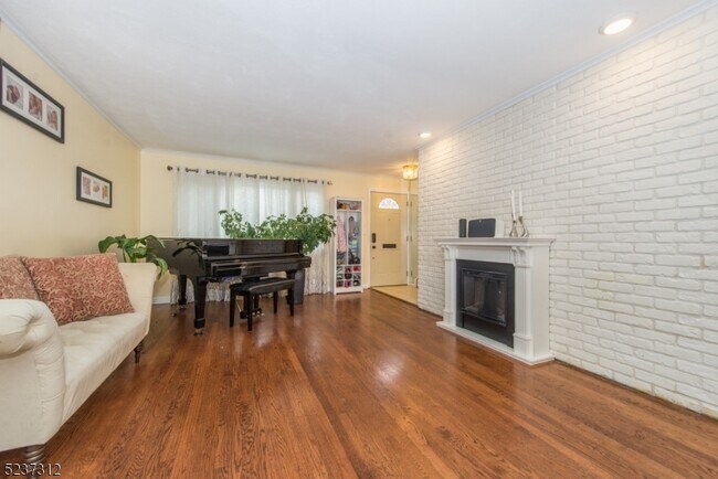
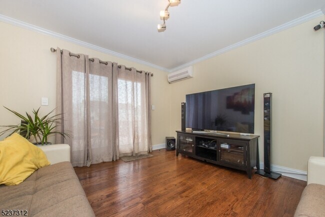
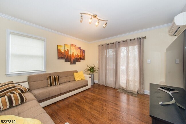
Updated Single Family home. Kitchen has stainless steel appliances and granite counter tops. Spacious first floor is perfect for entertaining with Large dining room and living room. Back yard with privacy fencing, two tier deck, pristine landscaping and patio provides a place to relax and enjoy your time off. Solar panels provide reduced electricity costs. This home will not disappoint, come see for yourself..... Note: No basement access other than utility maintenance.
1018 Stone St is a house located in Union County and the 07083 ZIP Code. This area is served by the Twp Of Union Board Of Education attendance zone.
House Features
- Deck
Location
Get Directions
The large township of Union is a thriving northeastern New Jersey suburb, sitting adjacent to Elizabeth and less than five miles from Newark Liberty International Airport. The majority of the community’s landscape is covered by residential neighborhoods, with lush trees and upscale homes, apartments, and condos lining the streets.
The Downtown area surrounding Morris and Stuyvesant Avenues serves as a major hangout for locals, with everything from specialty shops and unique cafes to the historic Union Theater occupying the cozy storefronts. Kean University on the east end serves around 16,000 students and employs hundreds of locals as faculty and staff members.
Learn more about living in Union Township
Amenities
- Deck
Education
| Colleges & Universities | Distance | ||
|---|---|---|---|
| Colleges & Universities | Distance | ||
| Drive: | 7 min | 3.1 mi | |
| Drive: | 10 min | 4.2 mi | |
| Drive: | 13 min | 5.5 mi | |
| Drive: | 15 min | 6.8 mi |
1018 Stone St is within 7 minutes or 3.1 miles from Kean University. It is also near Union County Coll., Elizabeth and Union County College, Cranford.
Schools


Public Elementary School
Grades PK-5
420 Students
Nearby
Public Elementary & Middle School
Grades 5-8
981 Students
Attendance Zone
Public Elementary School
Grades PK-4
779 Students
Attendance Zone
Public High School
Grades 9-12
2,308 Students
Attendance Zone
Private Elementary, Middle & High School
Grades K-12
Nearby
Private Elementary & Middle School
Grades PK-8
347 Students
Nearby
School data provided by
 The GreatSchools Rating helps parents compare schools within a state based on a variety of school quality indicators and provides a helpful picture of how effectively each school serves all of its students. Ratings are on a scale of 1 (below average) to 10 (above average) and can include test scores, college readiness, academic progress, advanced courses, equity, discipline and attendance data. We also advise parents to visit schools, consider other information on school performance and programs, and consider family needs as part of the school selection process.
View GreatSchools Rating Methodology
Data provided by GreatSchools.org © 2025. All rights reserved.
View GreatSchools Rating Methodology
Data provided by GreatSchools.org © 2025. All rights reserved.
Transportation options available in Union Township include Norfolk Street Light Rail Station, located 7.1 miles from 1018 Stone St. 1018 Stone St is near Newark Liberty International, located 8.8 miles or 13 minutes away, and LaGuardia, located 28.1 miles or 48 minutes away.
| Transit / Subway | Distance | ||
|---|---|---|---|
| Transit / Subway | Distance | ||
| Drive: | 13 min | 7.1 mi | |
| Drive: | 13 min | 7.1 mi | |
| Drive: | 13 min | 7.2 mi | |
| Drive: | 13 min | 7.3 mi | |
| Drive: | 13 min | 7.9 mi |
| Commuter Rail | Distance | ||
|---|---|---|---|
| Commuter Rail | Distance | ||
| Drive: | 5 min | 2.5 mi | |
| Drive: | 8 min | 2.5 mi | |
| Drive: | 8 min | 2.8 mi | |
| Drive: | 9 min | 3.1 mi | |
| Drive: | 9 min | 3.5 mi |
| Airports | Distance | ||
|---|---|---|---|
| Airports | Distance | ||
|
Newark Liberty International
|
Drive: | 13 min | 8.8 mi |
|
LaGuardia
|
Drive: | 48 min | 28.1 mi |
Time and distance from 1018 Stone St.
| Shopping Centers | Distance | ||
|---|---|---|---|
| Shopping Centers | Distance | ||
| Drive: | 4 min | 1.1 mi | |
| Drive: | 4 min | 1.4 mi | |
| Drive: | 4 min | 1.5 mi |
1018 Stone St has 3 shopping centers within 1.5 miles, which is about a 4-minute drive. The miles and minutes will be for the farthest away property.
| Parks and Recreation | Distance | ||
|---|---|---|---|
| Parks and Recreation | Distance | ||
|
Cora Hartshorn Arboretum
|
Drive: | 10 min | 3.9 mi |
|
Reeves-Reed Arboretum
|
Drive: | 11 min | 4.5 mi |
|
Greenwood Gardens
|
Drive: | 12 min | 4.6 mi |
|
William Miller Sperry Observatory
|
Drive: | 11 min | 5.3 mi |
|
Turtle Back Zoo
|
Drive: | 17 min | 6.8 mi |
1018 Stone St has 5 parks within 6.8 miles, including Cora Hartshorn Arboretum, William Miller Sperry Observatory, and Reeves-Reed Arboretum.
| Hospitals | Distance | ||
|---|---|---|---|
| Hospitals | Distance | ||
| Drive: | 8 min | 4.2 mi | |
| Drive: | 12 min | 4.7 mi | |
| Drive: | 12 min | 4.9 mi |
1018 Stone St has 3 hospitals within 4.9 miles, the nearest is Newark Beth Israel Medical Center which is 4.2 miles away and a 8 minute drive.
| Military Bases | Distance | ||
|---|---|---|---|
| Military Bases | Distance | ||
| Drive: | 18 min | 8.5 mi | |
| Drive: | 16 min | 8.9 mi | |
| Drive: | 19 min | 12.7 mi |
1018 Stone St has 3 military bases within 12.7 miles, the nearest is Tamdques Reservation which is 8.5 miles away and a 18 minute drive.
You May Also Like
Similar Rentals Nearby


What Are Walk Score®, Transit Score®, and Bike Score® Ratings?
Walk Score® measures the walkability of any address. Transit Score® measures access to public transit. Bike Score® measures the bikeability of any address.
What is a Sound Score Rating?
A Sound Score Rating aggregates noise caused by vehicle traffic, airplane traffic and local sources

1018 Stone St
Union Township, NJ 07083