
$1,675
/ Month
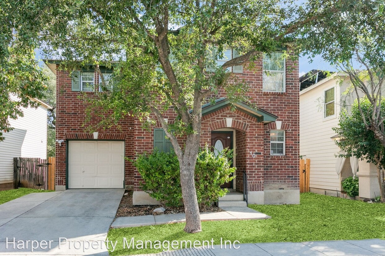
10 Kenrock Ridge
San Antonio, TX 78254
2 Weeks Ago
|
Edit
Favorites
10 Kenrock Ridge

Favorites
Check Back Soon for Upcoming Availability
| Beds | Baths | Average SF |
|---|---|---|
| 3 Bedrooms 3 Bedrooms 3 Br | 2.5 Baths 2.5 Baths 2.5 Ba | 1,676 SF |
Fees and Policies
The fees listed below are community-provided and may exclude utilities or add-ons. All payments are made directly to the property and are non-refundable unless otherwise specified.
- Dogs Allowed
-
Fees not specified
-
Weight limit--
-
Pet Limit--
About This Property
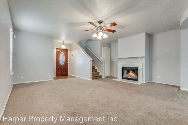
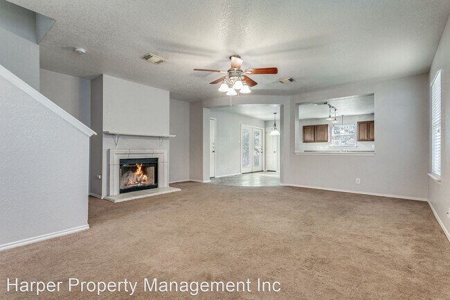
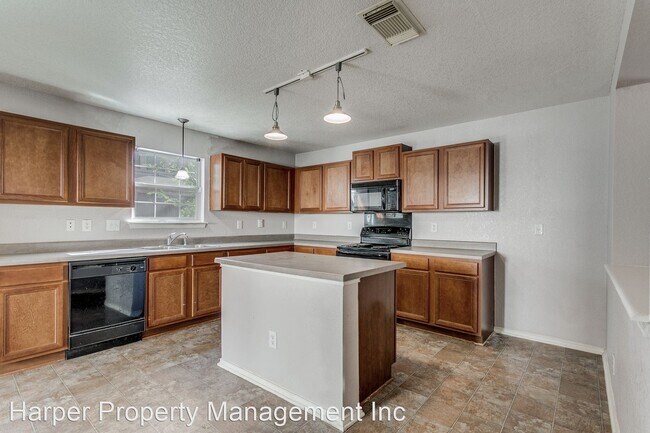
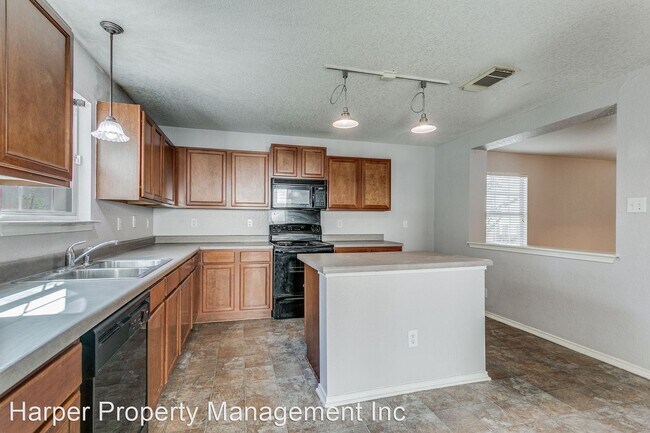
- 3 Bedroom 2.5 Bathroom located in Sagewood Subdivision - Wonderful Two-Story Home in Braun Hollow Subdivision! Discover the perfect blend of comfort and functionality in this two-story gem nestled within the desirable Braun Hollow subdivision. As you enter, you'll immediately notice the welcoming open floor plan featuring a spacious living room with a cozy fireplace - an ideal gathering spot during colder seasons. The kitchen is a true delight, boasting brown cabinetry, a kitchen island, a breakfast bar, and appliances that cater to your culinary needs. Venturing upstairs, you'll find all the bedrooms, each offering generous space and abundant natural light. The primary bedroom is your personal retreat, featuring a double sink vanity and a tub/shower combo. This home's location is incredibly convenient, with HEB, Walmart, Target, Bahama Bucks, Smashin' Crab, Gold's Gym, and Mac Wylie Golf Center just a stone's throw away. Please note that pets are negotiable, and renters insurance is required. Take advantage of this fantastic opportunity. Schedule a viewing today! (RLNE8253047) Pet policies: Small Dogs Allowed, Cats Allowed, Large Dogs Allowed.
10 Kenrock Ridge is a house located in Bexar County and the 78254 ZIP Code. This area is served by the Northside Independent School District (NISD) attendance zone.
10 Kenrock Ridge,
San Antonio,
TX
78254
Starting at the intersection of Bandera Road and East Charles William Anderson loop and extending along these highways south to New Guilbeau Road, Braun Station includes Braun’s Farm, Braun Station East, Oak Grove, and Saddlebrook Farms. The residential sections of the neighborhood contain a variety of architectural styles, from modest ranches and bungalows to large, two-story homes. Braun Station is about 15 miles northwest of Downtown San Antonio, and easy access to two major roadways help commuters get to the city in less than 30 minutes.
Commercial districts are scattered between the residential areas. At the intersection of Guilbeau Road and Tezel Road, you’ll find a Walmart, CVS, and Gold’s Gym. Farther down Guilbeau Road, where it meets Bandera Road, you’ll find several businesses, and H-E-B grocery store, several banks, and some chain restaurants.
Learn more about living in Braun StationBelow are rent ranges for similar nearby apartments
Education
| Colleges & Universities | Distance | ||
|---|---|---|---|
| Colleges & Universities | Distance | ||
| Drive: | 10 min | 5.1 mi | |
| Drive: | 12 min | 5.6 mi | |
| Drive: | 14 min | 7.1 mi | |
| Drive: | 15 min | 8.6 mi |
10 Kenrock Ridge is within 10 minutes or 5.1 miles from Galen Nursing - San Antonio. It is also near UT Health San Antonio and UT San Antonio.
Schools


Public Elementary School
Grades PK-5
390 Students
Attendance Zone
Public Middle School
Grades 6-8
999 Students
Attendance Zone
Public High School
Grades 9-12
2,634 Students
Attendance Zone
Private Elementary & Middle School
Grades PK-8
158 Students
Nearby
Private High School
Grades 9-12
Nearby
School data provided by
 The GreatSchools Rating helps parents compare schools within a state based on a variety of school quality indicators and provides a helpful picture of how effectively each school serves all of its students. Ratings are on a scale of 1 (below average) to 10 (above average) and can include test scores, college readiness, academic progress, advanced courses, equity, discipline and attendance data. We also advise parents to visit schools, consider other information on school performance and programs, and consider family needs as part of the school selection process.
View GreatSchools Rating Methodology
Data provided by GreatSchools.org © 2026. All rights reserved.
View GreatSchools Rating Methodology
Data provided by GreatSchools.org © 2026. All rights reserved.
Walkability Near 10 Kenrock Ridge San Antonio, TX 78254
Getting Around
 What do Walkability, Transit, Drivability, and Bikeability mean?
Walkability measures the walking distance to day-to-day needs.
Transit measures access to public transportation.
Drivability measures congestion, parking availability, and access to major roads.
Bikeability measures the suitability for cycling.
How It Works
What do Walkability, Transit, Drivability, and Bikeability mean?
Walkability measures the walking distance to day-to-day needs.
Transit measures access to public transportation.
Drivability measures congestion, parking availability, and access to major roads.
Bikeability measures the suitability for cycling.
How It Works
Fairly Walkable
Walkability
40
/ 100
Minimal Public Transit
Transit
0
/ 100
Very Drivable
Drivability
80
/ 100
Moderately Bikeable
Bikeability
70
/ 100
Scores provided by
-
Soundscore™
-
/ 100
Traffic
-Airport
-Businesses
-Scores provided by
HowLoud What is a Sound Score Rating? A Sound Score Rating aggregates noise caused by vehicle traffic, airplane traffic and local sources. How It WorksYou May Also Like
-
The Arbor at Riverstone Rental Homes
5512 Trinity Run
San Antonio, TX 78253
$2,035 - $2,535 Total Monthly Price
3-4 Br 12 Month Lease 8.5 mi
-
Beacon at Meridian Rental Homes
13034 Cygnus
San Antonio, TX 78245
$1,699 - $2,040
3-5 Br 11.3 mi
-
Artesia at Medina Valley
6304 Masterson Rd
San Antonio, TX 78252
$2,177 - $2,627
3 Br 12.7 mi
Similar Rentals Nearby
-
-
-
-
-
-
-
3 Beds$2,294+4 Beds$2,872Total Monthly PriceTotal Monthly Price NewPrices include base rent and required monthly fees of $119. Variable costs based on usage may apply.Base Rent:3 Beds$2,175+4 Beds$2,753Discounts
-
-
-


What Are Walk Score®, Transit Score®, and Bike Score® Ratings?
Walk Score® measures the walkability of any address. Transit Score® measures access to public transit. Bike Score® measures the bikeability of any address.
What is a Sound Score Rating?
A Sound Score Rating aggregates noise caused by vehicle traffic, airplane traffic and local sources.
10 Kenrock Ridge
San Antonio, TX 78254