
Woodland Park
45 Newell Rd,
East Palo Alto, CA 94303
$1,700 - $4,075 Total Monthly Price
Studio - 4 Beds 12 Month Lease
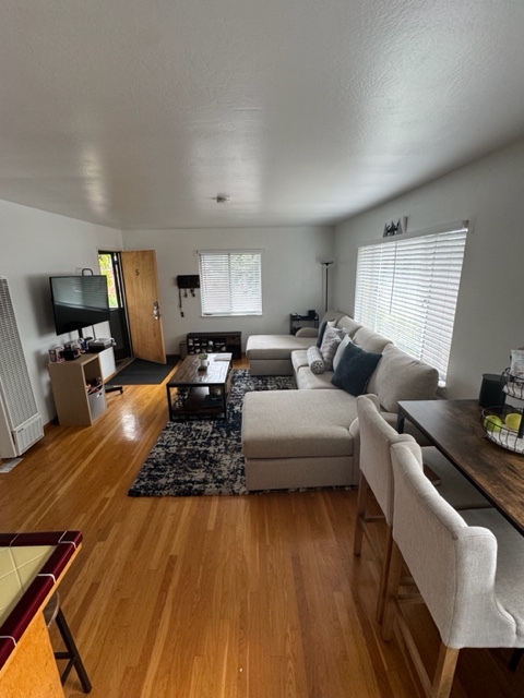

Discover this charming property located at 1637 Woodland Ave, East Palo Alto, CA 94303. A cozy property that is nestled in a quiet neighborhood, just minutes from major freeways. It is ideally situated and minutes from the vibrant downtown of Palo Alto where there is an array of dining options. Enjoy the benefits of living in an exceptionally commuter friendly neighborhood, where you will have many transportation options. This property provides you with the opportunity to use any transportation method you desire, whether you want to drive, bike, walk, or take public transportation, it is within walking distance to the Palo Alto Caltrain station and just seconds away from Highway 101. You will enjoy the serenity of this hidden gem that offers low maintenance living and surrounded by beautiful trees with easy access to transportation hubs. Other features include an on-site laundry facility, on-site covered parking, and a smoke-free community. Don't miss out on renting our upcoming 1 bedroom, 1 bathroom unit on the second floor that features: an open living room, kitchen bar top, stove, refrigerator, kitchen cabinets, laminate flooring, bath tub, and plenty of natural lighting. Additionally, the unit offers an assigned covered parking space and small storage cabinet.
Woodland Circle is an apartment community located in San Mateo County and the 94303 ZIP Code. This area is served by the Ravenswood City Elementary School District attendance zone.
Island Kitchen
Refrigerator
Tub/Shower
Tile Floors
East Palo Alto sits at the edge of San Francisco Bay in San Mateo County, positioned almost exactly halfway between San Francisco and San Jose on the Peninsula. That central location puts residents within reach of two major job markets, and the city itself has drawn tech industry investment that continues to reshape its small but dense three-square-mile footprint. Incorporated in 1983, it carries a distinct identity separate from neighboring Palo Alto, though the two cities are divided by little more than San Francisquito Creek. Stanford University sits about five miles to the southwest, reinforcing the area's academic and innovation-driven atmosphere.
The housing mix here runs toward apartment communities and rental homes rather than high-rises, offering options that tend to be more accessible than those in surrounding Peninsula cities. Ravenswood 101 serves as the main commercial corridor, anchoring everyday retail alongside the bay shoreline.
Learn more about living in East Palo Alto| Colleges & Universities | Distance | ||
|---|---|---|---|
| Colleges & Universities | Distance | ||
| Drive: | 11 min | 3.6 mi | |
| Drive: | 11 min | 4.0 mi | |
| Drive: | 8 min | 4.5 mi | |
| Drive: | 17 min | 8.8 mi |


Transportation options available in East Palo Alto include Bayshore Nasa Station, located 6.8 miles from Woodland Circle. Woodland Circle is near Norman Y Mineta San Jose International, located 14.4 miles or 19 minutes away, and San Francisco International, located 19.3 miles or 25 minutes away.
| Transit / Subway | Distance | ||
|---|---|---|---|
| Transit / Subway | Distance | ||
| Drive: | 9 min | 6.8 mi | |
| Drive: | 9 min | 7.2 mi | |
|
|
Drive: | 10 min | 7.4 mi |
|
|
Drive: | 10 min | 7.4 mi |
| Drive: | 10 min | 7.7 mi |
| Commuter Rail | Distance | ||
|---|---|---|---|
| Commuter Rail | Distance | ||
| Drive: | 6 min | 2.0 mi | |
| Drive: | 8 min | 3.1 mi | |
| Drive: | 8 min | 3.8 mi | |
| Drive: | 9 min | 5.2 mi | |
| Drive: | 10 min | 6.3 mi |
| Airports | Distance | ||
|---|---|---|---|
| Airports | Distance | ||
|
Norman Y Mineta San Jose International
|
Drive: | 19 min | 14.4 mi |
|
San Francisco International
|
Drive: | 25 min | 19.3 mi |
Scores provided by
Traffic
-Airport
-Businesses
-Scores provided by
HowLoud What is a Sound Score Rating? A Sound Score Rating aggregates noise caused by vehicle traffic, airplane traffic and local sources. How It WorksTime and distance from Woodland Circle.
| Shopping Centers | Distance | ||
|---|---|---|---|
| Shopping Centers | Distance | ||
| Walk: | 16 min | 0.9 mi | |
| Drive: | 3 min | 1.6 mi | |
| Drive: | 7 min | 2.1 mi |
| Parks and Recreation | Distance | ||
|---|---|---|---|
| Parks and Recreation | Distance | ||
|
Rinconada Park
|
Drive: | 3 min | 1.1 mi |
|
Junior Museum and Zoo
|
Drive: | 4 min | 1.4 mi |
|
Seminary Oaks Park
|
Drive: | 5 min | 1.6 mi |
|
Gamble Garden
|
Drive: | 5 min | 1.7 mi |
|
Hopkins Creekside Park
|
Drive: | 5 min | 1.7 mi |
| Hospitals | Distance | ||
|---|---|---|---|
| Hospitals | Distance | ||
| Drive: | 9 min | 2.9 mi | |
| Drive: | 10 min | 3.4 mi | |
| Drive: | 8 min | 5.7 mi |
| Military Bases | Distance | ||
|---|---|---|---|
| Military Bases | Distance | ||
| Drive: | 12 min | 7.2 mi | |
| Drive: | 50 min | 34.8 mi | |
| Drive: | 50 min | 35.0 mi |
Fitness Center Pool In Unit Washer & Dryer High-Speed Internet Stainless Steel Appliances Package Service
What Are Walk Score®, Transit Score®, and Bike Score® Ratings?
Walk Score® measures the walkability of any address. Transit Score® measures access to public transit. Bike Score® measures the bikeability of any address.
What is a Sound Score Rating?
A Sound Score Rating aggregates noise caused by vehicle traffic, airplane traffic and local sources.

1637 Woodland Ave
East Palo Alto, CA 94303


