
The Retreat at Walnut Creek
1459 Creekside Dr,
Walnut Creek, CA 94596
$2,041 - $4,308
Studio - 2 Beds

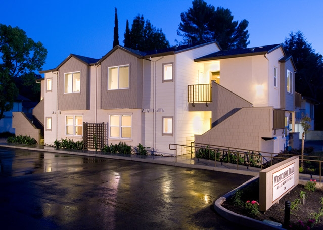
Westcliffe Trail is a residential community featuring two-bedroom apartments in Walnut Creek, CA. Situated on the Iron Horse Trail, Westcliffe Trails offers the best of both worlds combining nature and an ideal location within walking distance to shopping, dining, and entertainment options.Greystar California, Inc. dba Greystar Corp. License No. 1525765 Broker: Gerard S. Donohue License No. 01265072
Westcliffe Trail is an apartment community located in Contra Costa County and the 94597 ZIP Code. This area is served by the Walnut Creek Elementary attendance zone.
Playground
Grill
24 Hour Access
Maintenance on site
Air Conditioning
Dishwasher
High Speed Internet Access
Refrigerator
Conveniently located near Oakland and San Francisco, Walnut Creek is an East Bay community filled with rugged, wide-open spaces and an abundance of shopping opportunities, making it the ideal city for easy access to big-city amenities and the great outdoors. Walnut Creek is roughly 30 minutes from Oakland by vehicle, but if public transportation is your preference, this suburb also has direct BART service to both Oakland and San Fran!
Walnut Creek is home to numerous bike paths for both recreation and practical transportation—if you enjoy running your errands or getting to work by bike. Upscale apartments near downtown are very walkable, while rentals towards the east end offer residents easy access to nearby nature preserves and the city’s open spaces. Walnut Creek owns more open space per capita than any city in California, giving residents an enormous amount of room to enjoy outdoor activities.
Learn more about living in Walnut Creek| Colleges & Universities | Distance | ||
|---|---|---|---|
| Colleges & Universities | Distance | ||
| Drive: | 12 min | 4.9 mi | |
| Drive: | 20 min | 8.3 mi | |
| Drive: | 27 min | 15.8 mi | |
| Drive: | 30 min | 19.6 mi |


Transportation options available in Walnut Creek include Pleasant Hill Station, located 1.3 miles from Westcliffe Trail. Westcliffe Trail is near Metro Oakland International, located 25.7 miles or 37 minutes away, and San Francisco International, located 37.6 miles or 55 minutes away.
| Transit / Subway | Distance | ||
|---|---|---|---|
| Transit / Subway | Distance | ||
|
|
Drive: | 4 min | 1.3 mi |
|
|
Drive: | 5 min | 1.6 mi |
|
|
Drive: | 9 min | 5.7 mi |
|
|
Drive: | 11 min | 5.8 mi |
|
|
Drive: | 12 min | 7.4 mi |
| Commuter Rail | Distance | ||
|---|---|---|---|
| Commuter Rail | Distance | ||
|
|
Drive: | 17 min | 11.2 mi |
|
|
Drive: | 27 min | 17.0 mi |
|
|
Drive: | 26 min | 18.8 mi |
|
|
Drive: | 28 min | 20.0 mi |
|
|
Drive: | 30 min | 20.7 mi |
| Airports | Distance | ||
|---|---|---|---|
| Airports | Distance | ||
|
Metro Oakland International
|
Drive: | 37 min | 25.7 mi |
|
San Francisco International
|
Drive: | 55 min | 37.6 mi |
Time and distance from Westcliffe Trail.
| Shopping Centers | Distance | ||
|---|---|---|---|
| Shopping Centers | Distance | ||
| Drive: | 3 min | 1.1 mi | |
| Drive: | 3 min | 1.1 mi | |
| Drive: | 4 min | 1.8 mi |
| Parks and Recreation | Distance | ||
|---|---|---|---|
| Parks and Recreation | Distance | ||
|
Butterfly Habitat Gardens
|
Drive: | 3 min | 1.5 mi |
|
Civic Park
|
Drive: | 3 min | 1.5 mi |
|
Contra Costa Canal Regional Trail
|
Drive: | 4 min | 1.7 mi |
|
Gardens at Heather Farm
|
Drive: | 6 min | 2.4 mi |
|
Heather Farm Park
|
Drive: | 7 min | 2.5 mi |
| Hospitals | Distance | ||
|---|---|---|---|
| Hospitals | Distance | ||
| Drive: | 5 min | 2.0 mi | |
| Drive: | 6 min | 2.4 mi | |
| Drive: | 10 min | 6.3 mi |
What Are Walk Score®, Transit Score®, and Bike Score® Ratings?
Walk Score® measures the walkability of any address. Transit Score® measures access to public transit. Bike Score® measures the bikeability of any address.
What is a Sound Score Rating?
A Sound Score Rating aggregates noise caused by vehicle traffic, airplane traffic and local sources
2320 Westcliffe Ln
Walnut Creek, CA 94597


