
Venue Residences
3688 Overland Ave,
Los Angeles, CA 90034
$2,625 - $5,650
Studio - 2 Beds
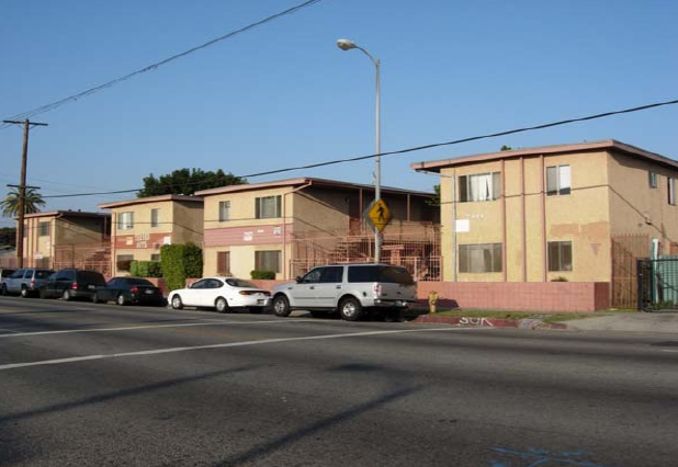

Turner Apartments offers a combination of design, comfort and quality. The 7000-7014 S. Hoover St. location in Los Angeles's 90044 Zip code is an ideal place to live. Be sure to see the current floorplan options. From availability to location, the professional leasing staff is ready to help match you with your perfect new place. Get a head start on your move right now. Contact or stop by the Turner Apartments leasing office to find out current pricing.
Turner Apartments is an apartment community located in Los Angeles County and the 90044 ZIP Code. This area is served by the Los Angeles Unified Rocp School District attendance zone.
Historic South-Central Los Angeles is a storied neighborhood in the South Los Angeles region. South LA is home to the University of Southern California, a top-ranking university founded in 1880, a close-knit community, and a rich past.
Renting an apartment in South Central LA places you in an active neighborhood near many LA hotspots. This neighborhood had one of America's first jazz scenes (often nicknamed the West Coast Harlem) and was home to Kid Ory, a famous trombonist, and bandleader. Today, South Central LA offers residents terrific proximity to downtown, USC, and a variety of historic sites in addition to numerous freeways.
Learn more about living in South Central LACompare neighborhood and city base rent averages by bedroom.
| South Central LA | Los Angeles, CA | |
|---|---|---|
| Studio | $1,033 | $1,709 |
| 1 Bedroom | $1,179 | $2,184 |
| 2 Bedrooms | $1,796 | $3,019 |
| 3 Bedrooms | $3,026 | $4,340 |
| Colleges & Universities | Distance | ||
|---|---|---|---|
| Colleges & Universities | Distance | ||
| Drive: | 8 min | 4.3 mi | |
| Drive: | 9 min | 4.4 mi | |
| Drive: | 8 min | 4.5 mi | |
| Drive: | 7 min | 4.7 mi |


Transportation options available in Los Angeles include Florence Station, located 2.7 miles from Turner Apartments. Turner Apartments is near Los Angeles International, located 8.3 miles or 15 minutes away, and Long Beach (Daugherty Field), located 17.2 miles or 23 minutes away.
| Transit / Subway | Distance | ||
|---|---|---|---|
| Transit / Subway | Distance | ||
|
|
Drive: | 5 min | 2.7 mi |
| Drive: | 6 min | 3.2 mi | |
| Drive: | 5 min | 3.5 mi | |
|
|
Drive: | 6 min | 3.6 mi |
|
|
Drive: | 6 min | 3.9 mi |
| Commuter Rail | Distance | ||
|---|---|---|---|
| Commuter Rail | Distance | ||
|
|
Drive: | 12 min | 8.1 mi |
|
|
Drive: | 14 min | 8.3 mi |
|
|
Drive: | 19 min | 10.3 mi |
|
|
Drive: | 21 min | 11.8 mi |
| Drive: | 15 min | 12.1 mi |
| Airports | Distance | ||
|---|---|---|---|
| Airports | Distance | ||
|
Los Angeles International
|
Drive: | 15 min | 8.3 mi |
|
Long Beach (Daugherty Field)
|
Drive: | 23 min | 17.2 mi |
Scores provided by
Traffic
BusyAirport
CalmBusinesses
BusyScores provided by
HowLoud What is a Sound Score Rating? A Sound Score Rating aggregates noise caused by vehicle traffic, airplane traffic and local sources. How It WorksTime and distance from Turner Apartments.
| Shopping Centers | Distance | ||
|---|---|---|---|
| Shopping Centers | Distance | ||
| Walk: | 6 min | 0.3 mi | |
| Walk: | 6 min | 0.3 mi | |
| Drive: | 2 min | 1.2 mi |
| Parks and Recreation | Distance | ||
|---|---|---|---|
| Parks and Recreation | Distance | ||
|
Augustus Hawkins Natural Park
|
Drive: | 5 min | 3.4 mi |
|
Natural History Museum of LA County
|
Drive: | 6 min | 3.5 mi |
|
California Science Center
|
Drive: | 6 min | 3.6 mi |
|
Exposition Park Rose Garden
|
Drive: | 6 min | 3.6 mi |
|
Watts Senior Center & Rose Garden
|
Drive: | 7 min | 4.6 mi |
| Hospitals | Distance | ||
|---|---|---|---|
| Hospitals | Distance | ||
| Drive: | 7 min | 4.6 mi | |
| Drive: | 9 min | 5.3 mi | |
| Drive: | 8 min | 5.3 mi |
| Military Bases | Distance | ||
|---|---|---|---|
| Military Bases | Distance | ||
| Drive: | 15 min | 10.5 mi | |
| Drive: | 26 min | 19.1 mi | |
| Drive: | 29 min | 21.4 mi |
What Are Walk Score®, Transit Score®, and Bike Score® Ratings?
Walk Score® measures the walkability of any address. Transit Score® measures access to public transit. Bike Score® measures the bikeability of any address.
What is a Sound Score Rating?
A Sound Score Rating aggregates noise caused by vehicle traffic, airplane traffic and local sources.

7000-7014 S Hoover St
Los Angeles, CA 90044


