
Fayette Arms Apartments
2680 Fayette Dr,
Mountain View, CA 94040
$3,626 - $3,868
1-2 Beds
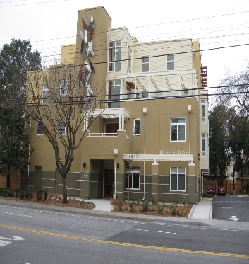
At Tree House Apartments, you've discovered your new place. The location of this community is in Palo Alto on W. Charleston Rd. in the 94306 area. From location to floorplan options, the leasing team is available to assist you in finding the perfect apartment. Come by to check out the current floorplan options. It's all waiting for you at Tree House Apartments. Stop by the leasing office to check the availability and set up a tour today.
Tree House Apartments is an apartment community located in Santa Clara County and the 94306 ZIP Code. This area is served by the Palo Alto Unified attendance zone.
Living in Palo Alto places you in Silicon Valley, where historic neighborhoods complement the city's technological presence. Tree-lined streets wind through the community, which is anchored by Stanford University. University Avenue features local boutiques and restaurants housed in preserved historic buildings, while the Stanford Shopping Center offers high-end retail destinations. The city maintains 36 parks and preserves, including the Baylands Nature Preserve and Foothills Park, where residents enjoy hiking trails and outdoor activities. Palo Alto's infrastructure supports alternative transportation, with dedicated bike lanes throughout the city.
The rental market in Palo Alto reflects the area's popularity, with current average rents ranging from $2,634 for studios to $6,139 for four-bedroom homes. Recent trends show steady growth, with rent increases varying from 1.8% to 17% across different unit sizes over the past year.
Learn more about living in Palo Alto| Colleges & Universities | Distance | ||
|---|---|---|---|
| Colleges & Universities | Distance | ||
| Drive: | 5 min | 1.4 mi | |
| Drive: | 9 min | 3.3 mi | |
| Drive: | 11 min | 4.5 mi | |
| Drive: | 13 min | 5.5 mi |


Transportation options available in Palo Alto include Mountain View Station, located 3.0 miles from Tree House Apartments. Tree House Apartments is near Norman Y Mineta San Jose International, located 12.3 miles or 19 minutes away, and San Francisco International, located 24.1 miles or 34 minutes away.
| Transit / Subway | Distance | ||
|---|---|---|---|
| Transit / Subway | Distance | ||
| Drive: | 6 min | 3.0 mi | |
|
|
Drive: | 6 min | 3.0 mi |
|
|
Drive: | 9 min | 4.3 mi |
| Drive: | 9 min | 4.7 mi | |
|
|
Drive: | 10 min | 4.9 mi |
| Commuter Rail | Distance | ||
|---|---|---|---|
| Commuter Rail | Distance | ||
| Drive: | 4 min | 1.6 mi | |
| Drive: | 5 min | 2.1 mi | |
| Drive: | 5 min | 2.3 mi | |
| Drive: | 9 min | 3.6 mi | |
| Drive: | 9 min | 3.7 mi |
| Airports | Distance | ||
|---|---|---|---|
| Airports | Distance | ||
|
Norman Y Mineta San Jose International
|
Drive: | 19 min | 12.3 mi |
|
San Francisco International
|
Drive: | 34 min | 24.1 mi |
Time and distance from Tree House Apartments.
| Shopping Centers | Distance | ||
|---|---|---|---|
| Shopping Centers | Distance | ||
| Walk: | 9 min | 0.5 mi | |
| Walk: | 14 min | 0.8 mi | |
| Walk: | 17 min | 0.9 mi |
| Parks and Recreation | Distance | ||
|---|---|---|---|
| Parks and Recreation | Distance | ||
|
Terman Park
|
Walk: | 16 min | 0.8 mi |
|
J. Pearce Mitchell Park
|
Drive: | 5 min | 1.4 mi |
|
Bol Park
|
Drive: | 4 min | 1.7 mi |
|
Esther Clark Nature Preserve
|
Drive: | 5 min | 1.8 mi |
|
Gamble Garden
|
Drive: | 7 min | 3.0 mi |
| Hospitals | Distance | ||
|---|---|---|---|
| Hospitals | Distance | ||
| Drive: | 10 min | 3.9 mi | |
| Drive: | 10 min | 4.3 mi | |
| Drive: | 11 min | 4.5 mi |
| Military Bases | Distance | ||
|---|---|---|---|
| Military Bases | Distance | ||
| Drive: | 13 min | 5.2 mi |
What Are Walk Score®, Transit Score®, and Bike Score® Ratings?
Walk Score® measures the walkability of any address. Transit Score® measures access to public transit. Bike Score® measures the bikeability of any address.
What is a Sound Score Rating?
A Sound Score Rating aggregates noise caused by vehicle traffic, airplane traffic and local sources


