
The Flats at Wasson Way
2881-2885 Minto Ave,
Cincinnati,
OH
45208
Today
|
Edit
Favorites
513-450-8382
-
Monthly Rent
$945 - $1,015
-
Bedrooms
Studio bd
-
Bathrooms
1 ba
-
Square Feet
260 - 370 sq ft
The Flats at Wasson Way
Favorites
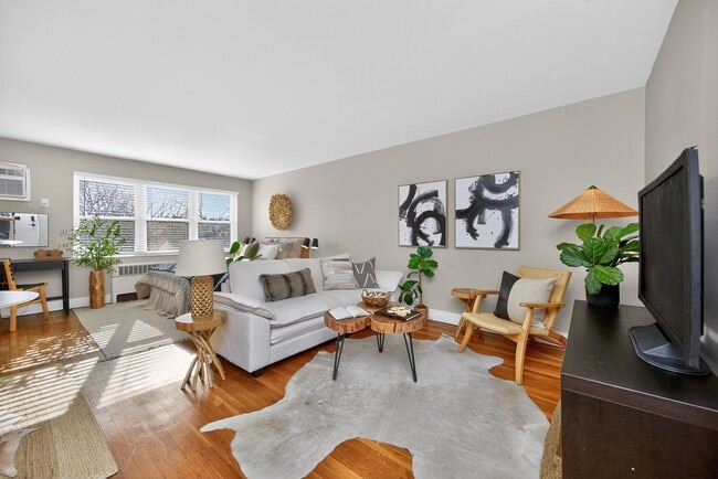
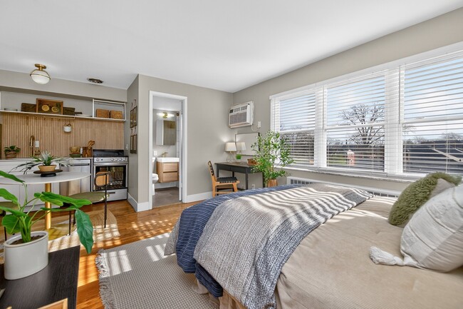
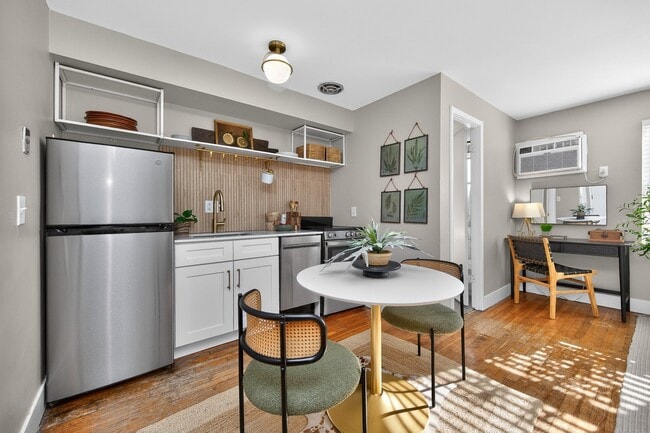
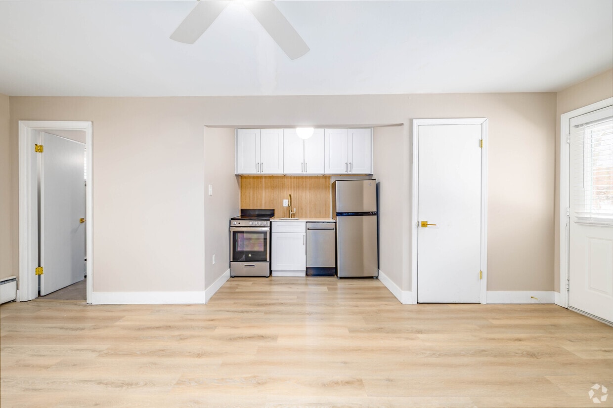
These updated studios offer a modern and comfortable living space, featuring stainless steel appliances, granite countertops, and keyless entry. The pet-friendly community includes convenient on-site laundry and off-street parking. Located in Hyde Park, you'll have easy access to local restaurants, shops, and the Wasson Way Trail.
Pricing & Floor Plans
Studio Plus
$1,015
Studio
1 Bath
370 Sq Ft
$500 Deposit
2 Available units
Unit
Base Price
Sq Ft
Availability
Unit Details
-
Unit 2885-11price $1,015square feet 370availibility Now
-
Unit 2885-7price $1,015square feet 370availibility May 18
Studio
$945
Studio
1 Bath
260 – 290 Sq Ft
$500 Deposit
1 Available unit
Unit
Base Price
Sq Ft
Availability
Unit Details
-
Unit 2881-9price $945square feet 290availibility May 11
* Price shown is base rent. Excludes user-selected optional fees and variable or usage-based fees and required charges due at or prior to move-in or at move-out.View Fees and Policies for details.
Price, availability, fees, and any applicable rent special are subject to change without notice.
* Square footage definitions vary. Displayed square footage is approximate.
Fees and Policies
The fees listed below are community-provided and may exclude utilities or add-ons. All payments are made directly to the property and are non-refundable unless otherwise specified. Use the Cost Calculator to determine costs based on your needs.
-
Dogs
-
One-Time Pet FeeMax of 2. Charged per pet.$250
-
Monthly Pet FeeMax of 2. Charged per pet.$50 / mo
0 lbs. Weight LimitRestrictions:Aggressive breeds such as Rottweiler, Pit Bull, and Doberman breeds of dogs are prohibited. This applies to pure bred and mixed breed dogs that have similar physical and behavioral characteristics or lineage.Read More Read LessComments -
-
Cats
-
One-Time Pet FeeMax of 2. Charged per pet.$250
-
Monthly Pet FeeMax of 2. Charged per pet.$50 / mo
0 lbs. Weight LimitRestrictions:Comments -
Property Fee Disclaimer: Based on community-supplied data and independent market research. Subject to change without notice. May exclude fees for mandatory or optional services and usage-based utilities.
Details
Lease Options
-
12 mo
Property Information
-
Built in 1959
-
27 units/3 stories
Matterport 3D Tours
About The Flats at Wasson Way
These updated studios offer a modern and comfortable living space, featuring stainless steel appliances, granite countertops, and keyless entry. The pet-friendly community includes convenient on-site laundry and off-street parking. Located in Hyde Park, you'll have easy access to local restaurants, shops, and the Wasson Way Trail.
The Flats at Wasson Way is an apartment community located in Hamilton County and the 45208 ZIP Code. This area is served by the Cincinnati Public Schools attendance zone.
Unique Features
- Fully-Renovated
- Keypad Entry
- Luxury Vinyl Wood Flooring
- Renovated Kitchens & Baths
Community Amenities
- Laundry Facilities
- Walking/Biking Trails
Apartment Features
- Granite Countertops
- Stainless Steel Appliances
2881-2885 Minto Ave,
Cincinnati,
OH
45208
Often regarded as Cincinnati’s most desirable neighborhood, Hyde Park is picturesque with charming historic homes and spacious tree-lined streets. At the center of the neighborhood lies Hyde Park Square, teeming with more than 175 unique shops, galleries, and restaurants for residents and visitors to explore.
In addition to Hyde Park Square, the neighborhood is known for containing the Cincinnati Observatory, a National Historic Landmark (and fully functional observatory) that’s home to the world’s oldest telescope. Hyde Park is also convenient to the expansive Ault Park, which is revered for its historic pavilion, lush gardens, and scenic trails.
Hyde Park fosters a sense of community with an array of exciting events, such as the annual Hyde Park Art Show, Hyde Park Blast, and the seasonal Hyde Park Farmers’ Market. Located just five miles from the heart of Downtown Cincinnati, Hyde Park offers residents easy access to all that the city has to offer.
Learn more about living in Hyde Park
Average Prices by Area
Compare neighborhood and city base rent averages by bedroom.
| Hyde Park | Cincinnati, OH | |
|---|---|---|
| Studio | $895 | $1,073 |
| 1 Bedroom | $1,145 | $1,135 |
| 2 Bedrooms | $1,624 | $1,424 |
| 3 Bedrooms | $1,800 | $1,731 |
Amenities
- Laundry Facilities
- Walking/Biking Trails
- Fully-Renovated
- Keypad Entry
- Luxury Vinyl Wood Flooring
- Renovated Kitchens & Baths
- Granite Countertops
- Stainless Steel Appliances
Expenses
Recurring
Cat Rent
$50
Dog Rent
$50
One-Time
Cat Fee
$250
Dog Fee
$250
Office Hours
513-450-8382
| Monday | 8am - 5pm |
|---|---|
| Tuesday | 8am - 5pm |
| Wednesday | 8am - 5pm |
| Thursday | 8am - 5pm |
| Friday | 8am - 5pm |
| Saturday | 9am - 3pm |
| Sunday | Closed |
Education
| Colleges & Universities | Distance | ||
|---|---|---|---|
| Colleges & Universities | Distance | ||
| Drive: | 8 min | 3.1 mi | |
| Drive: | 10 min | 4.8 mi | |
| Drive: | 10 min | 4.9 mi | |
| Drive: | 17 min | 7.6 mi |
The Flats at Wasson Way is within 8 minutes or 3.1 miles from Xavier University. It is also near Univ. of Cincinnati, Medical and University of Cincinnati.
Schools


Public Elementary School
Grades PK-5
413 Students
Nearby
Public Middle & High School
Grades 6-12
706 Students
Attendance Zone
Private Elementary & Middle School
Grades K-8
464 Students
Nearby
School data provided by
 The GreatSchools Rating helps parents compare schools within a state based on a variety of school quality indicators and provides a helpful picture of how effectively each school serves all of its students. Ratings are on a scale of 1 (below average) to 10 (above average) and can include test scores, college readiness, academic progress, advanced courses, equity, discipline and attendance data. We also advise parents to visit schools, consider other information on school performance and programs, and consider family needs as part of the school selection process.
View GreatSchools Rating Methodology
Data provided by GreatSchools.org © 2026. All rights reserved.
View GreatSchools Rating Methodology
Data provided by GreatSchools.org © 2026. All rights reserved.
Transportation options available in Cincinnati include Hanke Exchange Station - 12Th & Main, located 6.2 miles from The Flats at Wasson Way. The Flats at Wasson Way is near Cincinnati/Northern Kentucky International, located 20.7 miles or 37 minutes away.
| Transit / Subway | Distance | ||
|---|---|---|---|
| Transit / Subway | Distance | ||
| Drive: | 11 min | 6.2 mi | |
| Drive: | 11 min | 6.4 mi | |
| Drive: | 12 min | 6.5 mi | |
| Drive: | 12 min | 6.5 mi | |
| Drive: | 13 min | 6.8 mi |
| Commuter Rail | Distance | ||
|---|---|---|---|
| Commuter Rail | Distance | ||
|
|
Drive: | 16 min | 8.7 mi |
| Airports | Distance | ||
|---|---|---|---|
| Airports | Distance | ||
|
Cincinnati/Northern Kentucky International
|
Drive: | 37 min | 20.7 mi |
Getting Around
 What do Walkability, Transit, Drivability, and Bikeability mean?
Walkability measures the walking distance to day-to-day needs.
Transit measures access to public transportation.
Drivability measures congestion, parking availability, and access to major roads.
Bikeability measures the suitability for cycling.
How It Works
What do Walkability, Transit, Drivability, and Bikeability mean?
Walkability measures the walking distance to day-to-day needs.
Transit measures access to public transportation.
Drivability measures congestion, parking availability, and access to major roads.
Bikeability measures the suitability for cycling.
How It Works
Moderately Walkable
Walkability
70
/ 100
Limited Public Transit
Transit
30
/ 100
Very Drivable
Drivability
80
/ 100
Fairly Bikeable
Bikeability
50
/ 100
Scores provided by
Active
Soundscore™
74
/ 100
Traffic
ActiveAirport
CalmBusinesses
CalmScores provided by
HowLoud What is a Sound Score Rating? A Sound Score Rating aggregates noise caused by vehicle traffic, airplane traffic and local sources. How It WorksTime and distance from The Flats at Wasson Way.
| Shopping Centers | Distance | ||
|---|---|---|---|
| Shopping Centers | Distance | ||
| Walk: | 9 min | 0.5 mi | |
| Walk: | 12 min | 0.7 mi | |
| Walk: | 13 min | 0.7 mi |
The Flats at Wasson Way has 3 shopping centers within 0.7 mile, which is about a 13-minute walk. The miles and minutes will be for the farthest away property.
| Parks and Recreation | Distance | ||
|---|---|---|---|
| Parks and Recreation | Distance | ||
|
Cincinnati Observatory
|
Drive: | 4 min | 1.4 mi |
|
Ault Park
|
Drive: | 4 min | 1.6 mi |
|
Otto Armleder Park
|
Drive: | 10 min | 3.8 mi |
|
Eden Park
|
Drive: | 10 min | 4.0 mi |
|
Avon Woods Natural Area/Preserve
|
Drive: | 10 min | 4.1 mi |
The Flats at Wasson Way has 5 parks within 4.1 miles, including Cincinnati Observatory, Ault Park, and Otto Armleder Park.
| Hospitals | Distance | ||
|---|---|---|---|
| Hospitals | Distance | ||
| Drive: | 8 min | 3.0 mi | |
| Drive: | 8 min | 4.5 mi | |
| Drive: | 9 min | 4.7 mi |
The Flats at Wasson Way has 3 hospitals within 4.7 miles, the nearest is Blueridge Vista Health and Wellness which is 3.0 miles away and a 8 minute drive.
| Military Bases | Distance | ||
|---|---|---|---|
| Military Bases | Distance | ||
| Drive: | 70 min | 51.9 mi | |
| Drive: | 76 min | 57.0 mi | |
| Drive: | 79 min | 60.3 mi |
The Flats at Wasson Way has 3 military bases within 60.3 miles, the nearest is Gentile Air Force Station which is 51.9 miles away and a 70 minute drive.
The Flats at Wasson Way Photos
-
The Flats at Wasson Way
-
Studio
-
Studio Plus Living Room
-
Studio Plus Bedroom
-
Studio Plus Kitchen
-
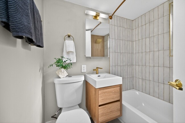
Studio Plus Bathroom
-
Studio Plus Bathroom
-
STUDIO, 1BA - 370SF - Living Room
-
STUDIO, 1BA - 370SF - Primary Bathroom
Models
-
Flats at Wasson Way - Studio
-
Flats at Wasson Way - Studio
-
Flats at Wasson Way - Studio
-
Flats at Wasson Way - Studio
-
Studio Plus Living Room
-
Studio Plus Bedroom
Nearby Apartments
Within 50 Miles of The Flats at Wasson Way
-
The Flats at Wasson Way II
2837 Minto Ave
Cincinnati, OH 45208
Call for Rent
0.1 mi
-
Somerset Apartments
735 Delta Ave
Cincinnati, OH 45226
$1,405 - $1,495
2 Br 1.2 mi
-
Grandview Apartments
2400 Grandview Ave
Cincinnati, OH 45206
$1,095 - $1,525
1-2 Br 2.7 mi
-
Mariemont Square Apartments
3900 Oak St
Cincinnati, OH 45227
Call for Rent
1 Br 2.9 mi
-
The Alcove of Turpin Hills
6375 Clough Pike
Cincinnati, OH 45244
$1,175 - $1,595
1-2 Br 4.3 mi
-
Cadence of Newport
210 W 5th St
Newport, KY 41071
$1,295 - $1,800
1-2 Br 5.0 mi
Does The Flats at Wasson Way have in-unit laundry?
While The Flats at Wasson Way does not provide in‑unit laundry, on‑site laundry facilities are available for shared resident use.
What utilities are included in rent at The Flats at Wasson Way?
Utilities are not included in rent. Residents should plan to set up and pay for all services separately.
Is parking available at The Flats at Wasson Way?
Contact this property for parking details.
Is The Flats at Wasson Way pet-friendly?
Yes, The Flats at Wasson Way welcomes pets. Breed restrictions, weight limits, and additional fees may apply. View this property's pet policy.
How much income do I need to rent at The Flats at Wasson Way?
A good rule of thumb is to spend no more than 30% of your gross income on rent. Based on the lowest available rent of $945 for a studio, you would need to earn about $37,800 per year to qualify. Want to double-check your budget? Calculate how much rent you can afford with our Rent Affordability Calculator.
Does The Flats at Wasson Way have move-in specials?
The Flats at Wasson Way is not currently offering any rent specials. Check back soon, as promotions change frequently.
Does The Flats at Wasson Way offer Matterport 3D tours?
Yes! The Flats at Wasson Way offers 4 Matterport 3D Tours. Explore different floor plans and see unit level details, all without leaving home.
What Are Walk Score®, Transit Score®, and Bike Score® Ratings?
Walk Score® measures the walkability of any address. Transit Score® measures access to public transit. Bike Score® measures the bikeability of any address.
What is a Sound Score Rating?
A Sound Score Rating aggregates noise caused by vehicle traffic, airplane traffic and local sources.
2881-2885 Minto Ave
Cincinnati, OH 45208