
Kinect at Southport
2301 Jefferson Blvd,
Sacramento, CA 95691
$1,599 - $3,059
Studio - 3 Beds
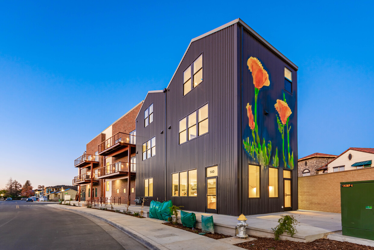

Sutter Parkway is a unique mixed-use project tucked into Sacramento’s (arguably) best neighborhood. This property has three small retail spaces that are currently being programmed for a coffee kiosk, a salon/barber, and a market/café. Each retail space has generous outdoor seating that sits proudly on the promenade overlooking the central neighborhood park. Above & beside the retail space are eleven residential units that include: (2) studio, and (9) one-bedroom homes. Of the (9) one-bedroom homes, (4) of these are single-floor, loft units, and (5) are two-story units that include an additional half-bath. Each home has controlled access from a central lobby that contains an elevator (for those pesky deliveries) and a central stairway. Design details for the residential units include Bosch kitchen appliances with panel covered refrigerators, Duravit plumbing fixtures for kitchen & bath, sleek dark grey kitchens & baths with solid surface counters, tiled bathroom wet rooms with tiled walls, and discrete washer & dryers in each unit. Most of the units include connected outdoor balconies with park views. Application fee $49 2.5x rent income requirement 1 Year Lease Term Pets are welcome with a $500 pet deposit, $25 per month pet rent, (breed and size restrictions apply). Owner pays gas, water, trash and sewer Resident pays electricity and optional internet/cable Call or email Bethany at [email address removed] for unit availability and application. For qualified applicants with verified rental history and credit. All applicants are screened in accordance with fair housing laws.
Sutter Parkway is an apartment community located in Sacramento County and the 95819 ZIP Code. This area is served by the Sacramento City Unified attendance zone.
Elevator
Controlled Access
24 Hour Access
Public Transportation
Washer/Dryer
Air Conditioning
Dishwasher
Loft Layout
High Speed Internet Access
Hardwood Floors
Walk-In Closets
Granite Countertops
East Sacramento offers renters a breath of fresh air in the city. Known for tree-lined streets and great parks, East Sacramento is one of the city’s best neighborhoods. The community features lavish apartments, condos, townhomes, and houses. Join your new friends and neighbors at popular McKinley Park, known for its elegant rose garden, food trucks, festivals, concerts, and outdoor movie nights. The neighborhood is also known for its stellar dining and nightlife scene. While living in East Sacramento, you’ll have easy access to craft breweries, trendy coffee shops, quaint boutiques, sports bars, and diverse eateries. Great for students as well, the community borders California State University, Sacramento. This vibrant neighborhood also offers close proximity to Midtown and Downtown Sacramento, which are both about four miles away.
Learn more about living in East Sacramento| Colleges & Universities | Distance | ||
|---|---|---|---|
| Colleges & Universities | Distance | ||
| Drive: | 4 min | 1.5 mi | |
| Drive: | 9 min | 5.1 mi | |
| Drive: | 18 min | 11.2 mi | |
| Drive: | 18 min | 11.9 mi |


Transportation options available in Sacramento include 48Th Street, located 1.4 miles from Sutter Parkway. Sutter Parkway is near Sacramento International, located 15.0 miles or 24 minutes away.
| Transit / Subway | Distance | ||
|---|---|---|---|
| Transit / Subway | Distance | ||
|
|
Drive: | 4 min | 1.4 mi |
|
|
Drive: | 3 min | 1.7 mi |
|
|
Drive: | 5 min | 1.8 mi |
|
|
Drive: | 5 min | 2.1 mi |
|
|
Drive: | 5 min | 2.6 mi |
| Commuter Rail | Distance | ||
|---|---|---|---|
| Commuter Rail | Distance | ||
| Drive: | 9 min | 4.3 mi | |
|
|
Drive: | 24 min | 18.3 mi |
|
|
Drive: | 28 min | 19.8 mi |
|
|
Drive: | 29 min | 21.9 mi |
|
|
Drive: | 42 min | 34.2 mi |
| Airports | Distance | ||
|---|---|---|---|
| Airports | Distance | ||
|
Sacramento International
|
Drive: | 24 min | 15.0 mi |
Time and distance from Sutter Parkway.
| Shopping Centers | Distance | ||
|---|---|---|---|
| Shopping Centers | Distance | ||
| Walk: | 8 min | 0.4 mi | |
| Walk: | 10 min | 0.5 mi | |
| Walk: | 17 min | 0.9 mi |
| Parks and Recreation | Distance | ||
|---|---|---|---|
| Parks and Recreation | Distance | ||
|
Paradise Beach County Recreation Area
|
Walk: | 16 min | 0.8 mi |
|
Sutter's Fort State Historical Monument
|
Drive: | 5 min | 2.3 mi |
|
Governor's Mansion State Historic Park
|
Drive: | 7 min | 3.5 mi |
|
California State Capitol Museum
|
Drive: | 8 min | 3.9 mi |
|
Leland Stanford Mansion State Historic Park
|
Drive: | 8 min | 3.9 mi |
| Hospitals | Distance | ||
|---|---|---|---|
| Hospitals | Distance | ||
| Walk: | 20 min | 1.0 mi | |
| Drive: | 7 min | 3.3 mi | |
| Drive: | 7 min | 3.4 mi |
| Military Bases | Distance | ||
|---|---|---|---|
| Military Bases | Distance | ||
| Drive: | 26 min | 12.1 mi |
What Are Walk Score®, Transit Score®, and Bike Score® Ratings?
Walk Score® measures the walkability of any address. Transit Score® measures access to public transit. Bike Score® measures the bikeability of any address.
What is a Sound Score Rating?
A Sound Score Rating aggregates noise caused by vehicle traffic, airplane traffic and local sources

533 53rd St
Sacramento, CA 95819


