
Sylvan Woods Evesham
3 Executive Dr,
Evesham, NJ 08053
$2,206 - $3,905 Total Monthly Price
1-2 Beds

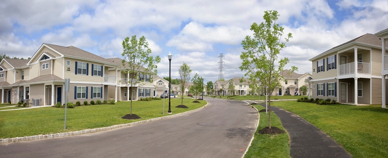
Sharp Road Apartments in Marlton is ready for you to move in. The location in Marlton's 08053 area is an ideal place to live. This community offers 1 to 3 bedroom floorplan options. You'll experience a wide selection of features and amenities at this community. Some of these include: a clubhouse, a state-of-the-art fitness center, and smoke free options. Visit Sharp Road Apartments today.
Sharp Road Apartments is an apartment community located in Burlington County and the 08053 ZIP Code. This area is served by the Evesham Township School District attendance zone.
Fitness Center
Laundry Facilities
Clubhouse
Business Center
Washer/Dryer Hookup
High Speed Internet Access
Refrigerator
Smoke Free
Chain and local restaurants, parks and green space, movie theaters, retail stores, grocery stores, and more lie in Marlton, New Jersey. The convenience of this small town is a factor in its popularity with its residents. This area is very family-friendly with access to parks and play centers like Pump It Up. Its large indoor inflatables are great for the kids. Though rental prices are a little higher in this area, Marlton’s safe neighborhoods and quick commute to bigger cities is worth the cost.
The AMC movie theater, Whole Foods, Trader Joe’s, and shopping options at Greentree Square are great amenities in Marlton. For classic diner food that’s serving 24/7, make sure to check out Marlton Diner. Less than 20 minutes from Philadelphia, Marlton is the convenient spot you’ve been looking for.
Learn more about living in Marlton| Colleges & Universities | Distance | ||
|---|---|---|---|
| Colleges & Universities | Distance | ||
| Drive: | 13 min | 5.6 mi | |
| Drive: | 24 min | 14.4 mi | |
| Drive: | 29 min | 15.8 mi | |
| Drive: | 32 min | 18.1 mi |


Transportation options available in Marlton include Haddonfield, located 10.4 miles from Sharp Road Apartments. Sharp Road Apartments is near Philadelphia International, located 25.7 miles or 42 minutes away, and Trenton Mercer, located 34.1 miles or 51 minutes away.
| Transit / Subway | Distance | ||
|---|---|---|---|
| Transit / Subway | Distance | ||
|
|
Drive: | 18 min | 10.4 mi |
|
|
Drive: | 18 min | 11.0 mi |
|
|
Drive: | 19 min | 11.1 mi |
|
|
Drive: | 20 min | 11.5 mi |
|
|
Drive: | 22 min | 11.7 mi |
| Commuter Rail | Distance | ||
|---|---|---|---|
| Commuter Rail | Distance | ||
|
|
Drive: | 18 min | 10.8 mi |
|
|
Drive: | 22 min | 11.6 mi |
| Drive: | 20 min | 12.9 mi | |
|
|
Drive: | 23 min | 14.4 mi |
|
|
Drive: | 31 min | 17.8 mi |
| Airports | Distance | ||
|---|---|---|---|
| Airports | Distance | ||
|
Philadelphia International
|
Drive: | 42 min | 25.7 mi |
|
Trenton Mercer
|
Drive: | 51 min | 34.1 mi |
Scores provided by
Traffic
-Airport
-Businesses
-Scores provided by
HowLoud What is a Sound Score Rating? A Sound Score Rating aggregates noise caused by vehicle traffic, airplane traffic and local sources. How It WorksTime and distance from Sharp Road Apartments.
| Shopping Centers | Distance | ||
|---|---|---|---|
| Shopping Centers | Distance | ||
| Drive: | 5 min | 2.3 mi | |
| Drive: | 7 min | 3.1 mi | |
| Drive: | 7 min | 3.3 mi |
| Parks and Recreation | Distance | ||
|---|---|---|---|
| Parks and Recreation | Distance | ||
|
Johnson's Corner Farm
|
Walk: | 21 min | 1.1 mi |
|
Paws Farm Nature Center
|
Drive: | 6 min | 3.7 mi |
|
Garden State Discovery Museum
|
Drive: | 11 min | 6.3 mi |
|
Kresson Nature Trails
|
Drive: | 14 min | 7.6 mi |
|
Rancocas State Park
|
Drive: | 15 min | 7.7 mi |
| Hospitals | Distance | ||
|---|---|---|---|
| Hospitals | Distance | ||
| Drive: | 11 min | 5.4 mi | |
| Drive: | 12 min | 7.7 mi | |
| Drive: | 16 min | 8.8 mi |
| Military Bases | Distance | ||
|---|---|---|---|
| Military Bases | Distance | ||
| Drive: | 32 min | 20.8 mi | |
| Drive: | 33 min | 21.2 mi | |
| Drive: | 40 min | 21.3 mi |
What Are Walk Score®, Transit Score®, and Bike Score® Ratings?
Walk Score® measures the walkability of any address. Transit Score® measures access to public transit. Bike Score® measures the bikeability of any address.
What is a Sound Score Rating?
A Sound Score Rating aggregates noise caused by vehicle traffic, airplane traffic and local sources.
267 Sharp Rd
Marlton, NJ 08053


