Secluded Pines

4100-4226 Secluded Pines Dr, Sterling Heights, MI 48314

2 Weeks Ago
Share Listing
Favorites
Secluded Pines
Share Listing
Favorites

Highlights

  • Walk-In Closets
  • Island Kitchen
  • Patio

About Secluded Pines

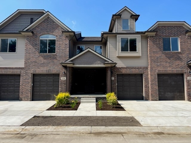
New construction Town Homes for lease in "Secluded Pines". Several 2 BR / 2.5 Bath units available, featuring an open floor plan, nice size kitchen with walk-in pantry. Sliding door to the patio area. Primary bedroom with full bath and 14x5 walk-in closet. Second floor laundry room. Unfinished basement for storage and an attached garage. All appliances included. One dog limit per townhome (15 lbs max) $35 per month extra. Water and trash allowance of $50 per month. Min. 1 year lease required.

Secluded Pines is an apartment community located in Macomb County and the 48314 ZIP Code. This area is served by the Utica Community Schools attendance zone.

Community Amenities

  • Laundry Facilities

Apartment Features

Washer/Dryer

Air Conditioning

Dishwasher

High Speed Internet Access

Walk-In Closets

Island Kitchen

Granite Countertops

Microwave

Indoor Features

  • High Speed Internet Access
  • Washer/Dryer
  • Air Conditioning
  • Heating
  • Ceiling Fans
  • Cable Ready
  • Storage Space
  • Double Vanities
  • Tub/Shower
  • Handrails

Kitchen Features & Appliances

  • Dishwasher
  • Disposal
  • Ice Maker
  • Granite Countertops
  • Stainless Steel Appliances
  • Pantry
  • Island Kitchen
  • Kitchen
  • Microwave
  • Oven
  • Range
  • Refrigerator
  • Freezer

Model Details

  • Vinyl Flooring
  • Basement
  • Walk-In Closets
  • Patio
Location
4100-4226 Secluded Pines Dr, Sterling Heights,
MI 48314
Get Directions
City - Sterling Heights

Sterling Heights sits about 18 miles north of Detroit, making it Michigan's fourth-most populous city and one of the largest suburbs in the state. Its identity is rooted in the automotive industry, with the Sterling Heights Assembly Plant operating within city limits and major employment hubs like the GM Tech Center in Warren and automotive campuses in Auburn Hills just a short drive away. The city incorporated in 1968 and grew rapidly from a small agricultural community into a sprawling suburban center covering 37 square miles.

Residents spread across well-established corridors and districts, including the Dodge Park and City Center area near the Clinton River, the Hall Road corridor close to Lakeside Mall, and quieter stretches along Plumbrook and Utica Road. Daily life tends to unfold by car, though SMART bus routes serve key roads like Van Dyke and Hall Road.

Learn more about living in Sterling Heights 
Education
Colleges & Universities Distance
Drive: 13 min 6.4 mi
Drive: 15 min 7.5 mi
Drive: 14 min 9.3 mi
Drive: 19 min 11.7 mi
Secluded Pines is within 13 minutes or 6.4 miles from Univ. of Detroit Mercy, Ctr. It is also near Walsh College of Business and Oakland C.C., Auburn Hills.
Schools
Public Elementary School
Grades PK-5
559 Students
Attendance Zone
Public Elementary & Middle School
Grades PK-8
168 Students
Nearby
Public Middle School
Grades 6-8
993 Students
Attendance Zone
Public High School
Grades 9-12
1,891 Students
Attendance Zone
Private Elementary & Middle School
Grades PK-8
737 Students
Nearby
Private Elementary, Middle & High School
Grades PK-12
300 Students
Nearby
Transportation

Secluded Pines is near Detroit Metro Wayne County, located 42.6 miles or 61 minutes away.

Commuter Rail Distance
Drive: 21 min 11.6 mi
Drive: 18 min 13.0 mi
Drive: 25 min 13.1 mi
Drive: 32 min 21.2 mi
Airports Distance
Airports Distance
Detroit Metro Wayne County
Drive: 61 min 42.6 mi

Walkability Near Secluded Pines

Getting Around
Fairly Walkable
Walkability
40 / 100
Minimal Public Transit
Transit
0 / 100
Exceptionally Drivable
Drivability
100 / 100
Moderately Bikeable
Bikeability
60 / 100

Scores provided by

What do Walkability, Transit, Drivability, and Bikeability mean? Walkability measures the walking distance to day-to-day needs. Transit measures access to public transportation. Drivability measures congestion, parking availability, and access to major roads. Bikeability measures the suitability for cycling. How It Works
-
Soundscore
- / 100

Traffic

-

Airport

-

Businesses

-

Scores provided by

HowLoud What is a Sound Score Rating? A Sound Score Rating aggregates noise caused by vehicle traffic, airplane traffic and local sources. How It Works
Points of Interest

Time and distance from Secluded Pines.

Shopping Centers Distance
Drive: 3 min 1.2 mi
Drive: 2 min 1.4 mi
Drive: 3 min 1.6 mi
Secluded Pines has 3 shopping centers within 1.6 miles, which is about a 3-minute drive. The miles and minutes will be for the farthest away property.
Parks and Recreation Distance
Burgess-Shadbush Nature Center
Drive: 4 min 2.2 mi
Sterling Heights Nature Center
Drive: 6 min 3.1 mi
Troy Historic Village
Drive: 12 min 7.0 mi
Rochester Hills Museum at Van Hoosen Farm
Drive: 13 min 7.6 mi
Freedom Hill County Park
Drive: 15 min 9.1 mi
Secluded Pines has 5 parks within 9.1 miles, including Burgess-Shadbush Nature Center, Sterling Heights Nature Center, and Troy Historic Village.
Hospitals Distance
Hospitals Distance
Drive: 4 min 1.7 mi
Drive: 12 min 6.8 mi
Drive: 14 min 8.2 mi
Secluded Pines has 3 hospitals within 8.2 miles, the nearest is Corewell Health Beaumont Troy Hospital which is 1.7 miles away and a 4 minute drive.
Military Bases Distance
Drive: 146 min 111.9 mi
Secluded Pines is 111.9 miles and a 146 minute drive from Camp Perry Air Guard Station.

Explore Similar Rentals Nearby