
Summit Apartments
901 Bradley Ct,
Mount Laurel, NJ 08054
$1,605 - $2,145
1-2 Beds
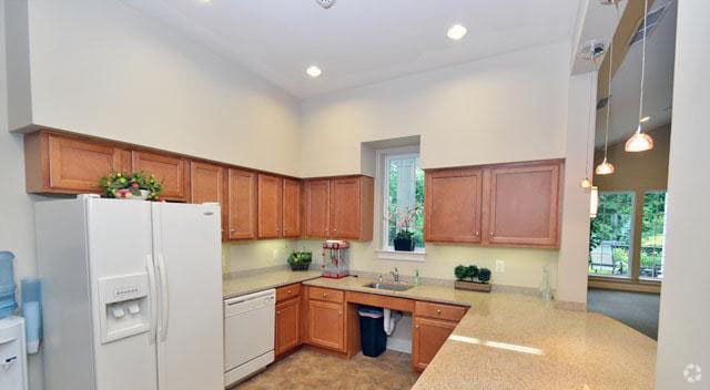
When you live at Roger's Walk you'll gain a fresh, new outlook on life. You'll have more time for you! The elegant clubhouse invites you to indulge yourself in the heated atrium pool, to enjoy a Yoga class, to see a captivating movie, or to join friends for coffee in front of the great room fireplace. This carefree, luxury lifestyle continues with you right into your beautiful apartment residence! Garages, fireplaces, granite counter tops, and other lavish amenities are just the beginning of the "extras" that are included with each apartment. Come discover the exciting lifestyle waiting for you at Roger's Walk!
Roger's Walk is an apartment community located in Burlington County and the 08054 ZIP Code. This area is served by the Mount Laurel Township School District attendance zone.
Unique Features
Pool
Fitness Center
Laundry Facilities
Furnished Units Available
Elevator
Concierge
Clubhouse
Controlled Access
Washer/Dryer
Air Conditioning
Dishwasher
High Speed Internet Access
Hardwood Floors
Walk-In Closets
Island Kitchen
Granite Countertops
| Colleges & Universities | Distance | ||
|---|---|---|---|
| Colleges & Universities | Distance | ||
| Drive: | 12 min | 6.6 mi | |
| Drive: | 16 min | 10.6 mi | |
| Drive: | 17 min | 11.0 mi | |
| Drive: | 25 min | 13.6 mi |


Transportation options available in Mount Laurel include Woodcrest, located 7.7 miles from Roger's Walk. Roger's Walk is near Philadelphia International, located 21.2 miles or 35 minutes away, and Trenton Mercer, located 34.4 miles or 49 minutes away.
| Transit / Subway | Distance | ||
|---|---|---|---|
| Transit / Subway | Distance | ||
|
|
Drive: | 13 min | 7.7 mi |
|
|
Drive: | 12 min | 8.0 mi |
|
|
Drive: | 13 min | 8.2 mi |
|
|
Drive: | 15 min | 8.3 mi |
|
|
Drive: | 14 min | 8.9 mi |
| Commuter Rail | Distance | ||
|---|---|---|---|
| Commuter Rail | Distance | ||
|
|
Drive: | 13 min | 7.8 mi |
| Drive: | 14 min | 8.3 mi | |
|
|
Drive: | 17 min | 9.5 mi |
|
|
Drive: | 19 min | 10.7 mi |
|
|
Drive: | 18 min | 10.9 mi |
| Airports | Distance | ||
|---|---|---|---|
| Airports | Distance | ||
|
Philadelphia International
|
Drive: | 35 min | 21.2 mi |
|
Trenton Mercer
|
Drive: | 49 min | 34.4 mi |
Scores provided by
Traffic
BusyAirport
CalmBusinesses
CalmScores provided by
HowLoud What is a Sound Score Rating? A Sound Score Rating aggregates noise caused by vehicle traffic, airplane traffic and local sources. How It WorksTime and distance from Roger's Walk.
| Shopping Centers | Distance | ||
|---|---|---|---|
| Shopping Centers | Distance | ||
| Walk: | 16 min | 0.9 mi | |
| Drive: | 5 min | 2.3 mi | |
| Drive: | 7 min | 3.2 mi |
| Parks and Recreation | Distance | ||
|---|---|---|---|
| Parks and Recreation | Distance | ||
|
Garden State Discovery Museum
|
Drive: | 6 min | 2.5 mi |
|
Kresson Nature Trails
|
Drive: | 10 min | 4.7 mi |
|
Barclay Farmstead Nature Trail
|
Drive: | 10 min | 5.0 mi |
|
Erlton North Trails
|
Drive: | 10 min | 5.8 mi |
|
Croft Farm Nature Trail
|
Drive: | 11 min | 6.1 mi |
| Hospitals | Distance | ||
|---|---|---|---|
| Hospitals | Distance | ||
| Drive: | 8 min | 4.5 mi | |
| Drive: | 9 min | 4.8 mi | |
| Drive: | 13 min | 7.2 mi |
| Military Bases | Distance | ||
|---|---|---|---|
| Military Bases | Distance | ||
| Drive: | 26 min | 16.3 mi | |
| Drive: | 47 min | 27.0 mi | |
| Drive: | 46 min | 27.3 mi |
What Are Walk Score®, Transit Score®, and Bike Score® Ratings?
Walk Score® measures the walkability of any address. Transit Score® measures access to public transit. Bike Score® measures the bikeability of any address.
What is a Sound Score Rating?
A Sound Score Rating aggregates noise caused by vehicle traffic, airplane traffic and local sources.
2100 Deal Dr
Mount Laurel, NJ 08054


