Beacon
3510 Beacon Ave,
Fremont, CA 94538
$2,610 - $3,785
Studio - 2 Beds

Reilly Station is an apartment community located in Alameda County and the 94539 ZIP Code.
Laundry Facilities
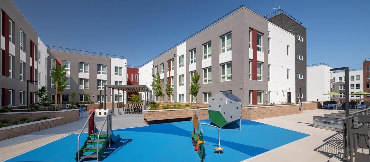
Playground
Clubhouse
Business Center
Air Conditioning
Refrigerator
Tub/Shower
Oven
Baylands is a commercial hub about six miles south of Downtown Fremont. Along with housing several light industry companies and business parks, Baylands residents have easy access to several large shopping centers and plazas including NewPark Mall and the Pacific Commons Shopping Center. Nestled along the San Francisco Bay, locals are close to some of the best outdoor recreation opportunities in the area. Explore the Coyote Lake Lagoon Trail, admire migrating birds at the Don Edwards San Francisco Bay National Wildlife Refuge, or go hang gliding at the Mission Peak Regional Preserve. Similar to other Fremont neighborhoods, rentals in this bayside locale are mid-range to upscale boasting sleek condos and luxury apartments.
Great for commuters, Baylands is highly accessible. Interstate 880 runs on the eastern edge of the neighborhood, making it easy to commute north to the San Francisco Bay area or south to San Jose and Silicon Valley.
Learn more about living in Baylands| Colleges & Universities | Distance | ||
|---|---|---|---|
| Colleges & Universities | Distance | ||
| Drive: | 6 min | 2.7 mi | |
| Drive: | 8 min | 4.6 mi | |
| Drive: | 14 min | 8.9 mi | |
| Drive: | 19 min | 13.7 mi |
Transportation options available in Fremont include Warm Springs / South Fremont, located 0.3 mile from Reilly Station. Reilly Station is near Norman Y Mineta San Jose International, located 13.0 miles or 18 minutes away, and Metro Oakland International, located 24.5 miles or 32 minutes away.
| Transit / Subway | Distance | ||
|---|---|---|---|
| Transit / Subway | Distance | ||
|
|
Walk: | 5 min | 0.3 mi |
|
|
Drive: | 10 min | 4.9 mi |
|
|
Drive: | 11 min | 5.0 mi |
|
|
Drive: | 11 min | 7.6 mi |
|
|
Drive: | 11 min | 7.7 mi |
| Commuter Rail | Distance | ||
|---|---|---|---|
| Commuter Rail | Distance | ||
| Drive: | 12 min | 5.8 mi | |
| Drive: | 11 min | 7.5 mi | |
| Drive: | 15 min | 10.6 mi | |
| Drive: | 20 min | 13.7 mi | |
| Drive: | 20 min | 14.2 mi |
| Airports | Distance | ||
|---|---|---|---|
| Airports | Distance | ||
|
Norman Y Mineta San Jose International
|
Drive: | 18 min | 13.0 mi |
|
Metro Oakland International
|
Drive: | 32 min | 24.5 mi |
Time and distance from Reilly Station.
| Shopping Centers | Distance | ||
|---|---|---|---|
| Shopping Centers | Distance | ||
| Walk: | 12 min | 0.7 mi | |
| Walk: | 17 min | 0.9 mi | |
| Drive: | 2 min | 1.2 mi |
| Parks and Recreation | Distance | ||
|---|---|---|---|
| Parks and Recreation | Distance | ||
|
Central Park (Lake Elizabeth)
|
Drive: | 10 min | 5.0 mi |
|
Niles Community Park
|
Drive: | 15 min | 7.4 mi |
|
Mission Peak Regional Preserve
|
Drive: | 21 min | 7.7 mi |
|
Alviso Marina County Park
|
Drive: | 13 min | 9.1 mi |
|
Ed Levin County Park
|
Drive: | 18 min | 10.9 mi |
| Hospitals | Distance | ||
|---|---|---|---|
| Hospitals | Distance | ||
| Drive: | 8 min | 4.3 mi | |
| Drive: | 10 min | 5.2 mi |
| Military Bases | Distance | ||
|---|---|---|---|
| Military Bases | Distance | ||
| Drive: | 23 min | 15.7 mi |
What Are Walk Score®, Transit Score®, and Bike Score® Ratings?
Walk Score® measures the walkability of any address. Transit Score® measures access to public transit. Bike Score® measures the bikeability of any address.
What is a Sound Score Rating?
A Sound Score Rating aggregates noise caused by vehicle traffic, airplane traffic and local sources
45108 Tom Blalock St
Fremont, CA 94539


