
Hazel 8
1618 Hazel Dr,
Cleveland, OH 44106
$1,650 - $2,850
1-2 Beds
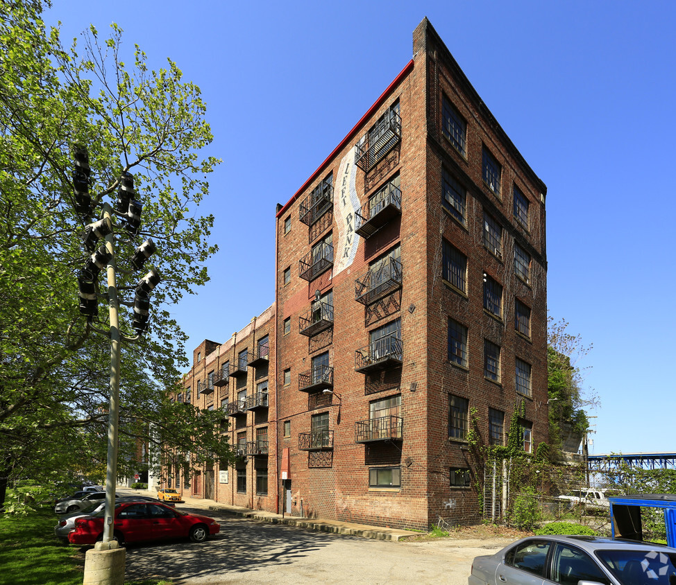
Left Bank Building offers a blend of comfort and style. This property is situated at 1250 Riverbed St. in the 44113 area of Cleveland. From amenities to floor plan options, the leasing staff is available to help you find your ideal place. Come see Left Bank Building today.
Left Bank Building is an apartment community located in Cuyahoga County and the 44113 ZIP Code. This area is served by the Cleveland Metropolitan attendance zone.
Located along beautiful Lake Erie, West Bank is a gorgeous waterfront community. The area is great for renters of any budget with affordable dwellings to luxury condos. Old River and the Cuyahoga River run through the neighborhood, providing dazzling scenery perfect for fishing, boating, and swimming. There are several yachts clubs and marinas along these rivers.
West Bank is home to Wendy Park and the Historic Cleveland Coast Guard Station. The extremely popular annual Burning River Fest is held at these two destinations for a two-day celebration of craft beer, wine, food trucks, and live music. Residents also love Wendy Park for its peaceful beaches. West Bank offers an abundance of entertainment opportunities year round as well.
Learn more about living in West Bank| Colleges & Universities | Distance | ||
|---|---|---|---|
| Colleges & Universities | Distance | ||
| Drive: | 8 min | 2.6 mi | |
| Drive: | 8 min | 3.0 mi | |
| Drive: | 17 min | 6.5 mi | |
| Drive: | 16 min | 8.7 mi |


Transportation options available in Cleveland include Settlers Landing Station, located 1.2 miles from Left Bank Building. Left Bank Building is near Cleveland-Hopkins International, located 12.5 miles or 25 minutes away.
| Transit / Subway | Distance | ||
|---|---|---|---|
| Transit / Subway | Distance | ||
| Drive: | 4 min | 1.2 mi | |
| Drive: | 4 min | 1.3 mi | |
|
|
Drive: | 4 min | 1.3 mi |
| Drive: | 4 min | 1.4 mi | |
| Drive: | 5 min | 1.6 mi |
| Commuter Rail | Distance | ||
|---|---|---|---|
| Commuter Rail | Distance | ||
|
|
Drive: | 9 min | 3.2 mi |
| Drive: | 21 min | 10.6 mi | |
| Drive: | 23 min | 12.4 mi | |
| Drive: | 31 min | 18.3 mi | |
|
Boston Mill
|
Drive: | 38 min | 23.3 mi |
| Airports | Distance | ||
|---|---|---|---|
| Airports | Distance | ||
|
Cleveland-Hopkins International
|
Drive: | 25 min | 12.5 mi |
Time and distance from Left Bank Building.
| Shopping Centers | Distance | ||
|---|---|---|---|
| Shopping Centers | Distance | ||
| Drive: | 4 min | 1.1 mi | |
| Drive: | 6 min | 1.7 mi | |
| Drive: | 7 min | 2.2 mi |
| Parks and Recreation | Distance | ||
|---|---|---|---|
| Parks and Recreation | Distance | ||
|
Lakefront Reservation and Edgewater Park
|
Drive: | 5 min | 2.1 mi |
|
Great Lakes Science Center
|
Drive: | 6 min | 2.4 mi |
|
Cleveland Metroparks Zoo
|
Drive: | 10 min | 3.9 mi |
|
Ohio & Erie Canal Reservation
|
Drive: | 12 min | 6.0 mi |
|
Children's Museum of Cleveland
|
Drive: | 15 min | 6.1 mi |
| Hospitals | Distance | ||
|---|---|---|---|
| Hospitals | Distance | ||
| Walk: | 14 min | 0.7 mi | |
| Drive: | 7 min | 2.6 mi | |
| Drive: | 9 min | 2.7 mi |
| Military Bases | Distance | ||
|---|---|---|---|
| Military Bases | Distance | ||
| Drive: | 99 min | 81.3 mi | |
| Drive: | 102 min | 82.1 mi |
What Are Walk Score®, Transit Score®, and Bike Score® Ratings?
Walk Score® measures the walkability of any address. Transit Score® measures access to public transit. Bike Score® measures the bikeability of any address.
What is a Sound Score Rating?
A Sound Score Rating aggregates noise caused by vehicle traffic, airplane traffic and local sources


")

