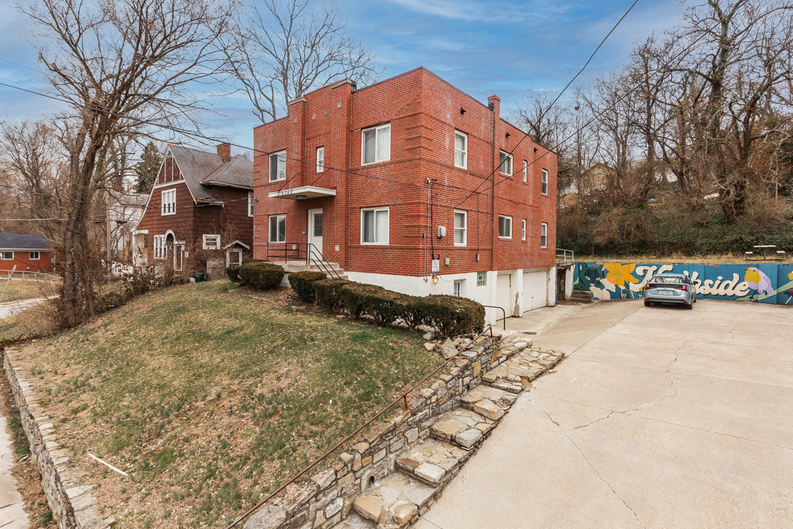
Kirby's Dreamland
4344-4348 Kirby Ave,
Cincinnati,
OH
45223
-
Monthly Rent
$1,195
-
Bedrooms
2 bd
-
Bathrooms
1 ba
-
Square Feet
--

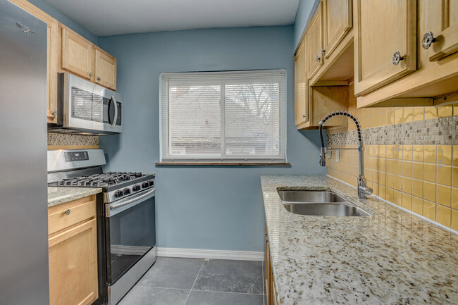
Taking great care of our tenants comes down to three simple things. Call or text us today to ask how we excel at all three! Welcome to Kirby’s Dreamland! This newly upgraded 1-bedroom apartment is close to all the attractions in the heart of Northside, with easy access to I-74, I-75, and US-27 (Colerain Ave). The kitchen includes granite countertops, decorative tile backsplash, dishwasher, microwave mounted over the oven, and refrigerator with ice and water service on the door. Limited off-street parking available with plenty of on-street parking. Pet friendly with pet rent. We will provide up to two window A/Cs. Coin laundry in the basement. Tenant pays electricity, which includes heat. Water/Sewer, Trash/Recycling, and Gas are included in the rent. No smoking is allowed. No pets are allowed. Background checks are required. Voucher are not accepted. A credit score of 600+ or a co-signer with 700+ is required. Application fees are reduced after you tour the apartment in person. Call or text us today to schedule a tour!
Pricing & Floor Plans
Fees and Policies
The fees listed below are community-provided and may exclude utilities or add-ons. All payments are made directly to the property and are non-refundable unless otherwise specified.
-
One-Time Basics
-
Due at Application
-
Application Fee Per ApplicantCharged per applicant.$60
-
-
Due at Application
-
Dogs
-
One-Time Pet FeeCharged per pet.$0
-
Pet DepositCharged per pet.$0
-
Monthly Pet FeeCharged per pet.$0 / mo
Restrictions:Pet fee is 5% of the market rentRead More Read Less -
-
Cats
-
One-Time Pet FeeCharged per pet.$0
-
Pet DepositCharged per pet.$0
-
Monthly Pet FeeCharged per pet.$0 / mo
Restrictions: -
-
Street Parking
-
Parking FeeCharged per vehicle.$0 / mo
-
-
Parking
-
Parking FeeCharged per vehicle.$0 / mo
-
Property Fee Disclaimer: Based on community-supplied data and independent market research. Subject to change without notice. May exclude fees for mandatory or optional services and usage-based utilities.
Details
Lease Options
-
12 mo
Property Information
-
Built in 1939
-
8 units/2 stories
About Kirby's Dreamland
Taking great care of our tenants comes down to three simple things. Call or text us today to ask how we excel at all three! Welcome to Kirby’s Dreamland! This newly upgraded 1-bedroom apartment is close to all the attractions in the heart of Northside, with easy access to I-74, I-75, and US-27 (Colerain Ave). The kitchen includes granite countertops, decorative tile backsplash, dishwasher, microwave mounted over the oven, and refrigerator with ice and water service on the door. Limited off-street parking available with plenty of on-street parking. Pet friendly with pet rent. We will provide up to two window A/Cs. Coin laundry in the basement. Tenant pays electricity, which includes heat. Water/Sewer, Trash/Recycling, and Gas are included in the rent. No smoking is allowed. No pets are allowed. Background checks are required. Voucher are not accepted. A credit score of 600+ or a co-signer with 700+ is required. Application fees are reduced after you tour the apartment in person. Call or text us today to schedule a tour!
Kirby's Dreamland is an apartment community located in Hamilton County and the 45223 ZIP Code. This area is served by the Cincinnati Public Schools attendance zone.
Contact
Community Amenities
- Laundry Facilities
- Trash Pickup - Curbside
- Recycling
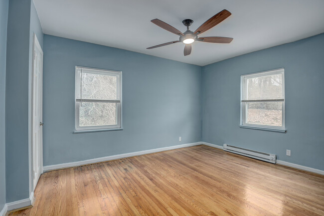
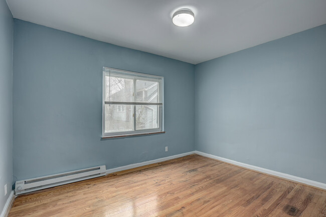
Apartment Features
Air Conditioning
Dishwasher
Granite Countertops
Microwave
- Air Conditioning
- Heating
- Ceiling Fans
- Smoke Free
- Tub/Shower
- Dishwasher
- Granite Countertops
- Stainless Steel Appliances
- Kitchen
- Microwave
- Oven
- Refrigerator
- Freezer
- Vinyl Flooring
- Basement
- Window Coverings
Northside is one of Cincinnati’s trendiest neighborhoods. This diverse, eclectic neighborhood is known for its artistic feel and walkability. With murals, live music, and a bustling commercial hub, Northside combines the excitement of urban living with the charm of a small town. This vibrant locale is home to a variety of quirky shops, restaurants, breweries, coffeehouses, art galleries, and more. Annual events like the Northside 4th of July Parade and Rock ‘n’ Roll Carnival keep the neighborhood lively as well. Northside's tradition of community activism attracts renters seeking a close-knit neighborhood.
Tucked away just a short trip from downtown, Northside is also convenient to Xavier University, the University of Cincinnati, and Cincinnati State Technical and Community College. Providing something for everyone, Northside is more affordable compared to other Cincinnati neighborhoods. Rentals range from single-family houses to apartments in brick buildings.
Learn more about living in NorthsideCompare neighborhood and city base rent averages by bedroom.
| Northside | Cincinnati, OH | |
|---|---|---|
| Studio | $1,114 | $1,062 |
| 1 Bedroom | $1,005 | $1,129 |
| 2 Bedrooms | $1,468 | $1,409 |
| 3 Bedrooms | - | $1,699 |
- Laundry Facilities
- Trash Pickup - Curbside
- Recycling
- Air Conditioning
- Heating
- Ceiling Fans
- Smoke Free
- Tub/Shower
- Dishwasher
- Granite Countertops
- Stainless Steel Appliances
- Kitchen
- Microwave
- Oven
- Refrigerator
- Freezer
- Vinyl Flooring
- Basement
- Window Coverings
| Monday | 8am - 6pm |
|---|---|
| Tuesday | 8am - 6pm |
| Wednesday | 8am - 6pm |
| Thursday | 8am - 6pm |
| Friday | 8am - 6pm |
| Saturday | 8am - 6pm |
| Sunday | 8am - 6pm |
| Colleges & Universities | Distance | ||
|---|---|---|---|
| Colleges & Universities | Distance | ||
| Drive: | 7 min | 2.3 mi | |
| Drive: | 11 min | 3.8 mi | |
| Drive: | 9 min | 4.4 mi | |
| Drive: | 14 min | 6.4 mi |


View GreatSchools Rating Methodology
Data provided by GreatSchools.org © 2026. All rights reserved.
Transportation options available in Cincinnati include Brewery District Station - Elm & Henry, located 5.1 miles from Kirby's Dreamland. Kirby's Dreamland is near Cincinnati/Northern Kentucky International, located 19.1 miles or 34 minutes away.
| Transit / Subway | Distance | ||
|---|---|---|---|
| Transit / Subway | Distance | ||
| Drive: | 10 min | 5.1 mi | |
| Drive: | 10 min | 5.2 mi | |
| Drive: | 10 min | 5.3 mi | |
| Drive: | 11 min | 5.3 mi | |
| Drive: | 11 min | 5.4 mi |
| Commuter Rail | Distance | ||
|---|---|---|---|
| Commuter Rail | Distance | ||
|
|
Drive: | 9 min | 5.1 mi |
| Airports | Distance | ||
|---|---|---|---|
| Airports | Distance | ||
|
Cincinnati/Northern Kentucky International
|
Drive: | 34 min | 19.1 mi |
Time and distance from Kirby's Dreamland.
| Shopping Centers | Distance | ||
|---|---|---|---|
| Shopping Centers | Distance | ||
| Drive: | 5 min | 2.2 mi | |
| Drive: | 6 min | 2.9 mi | |
| Drive: | 7 min | 3.3 mi |
| Parks and Recreation | Distance | ||
|---|---|---|---|
| Parks and Recreation | Distance | ||
|
Buttercup Valley
|
Walk: | 11 min | 0.6 mi |
|
LaBoiteaux Woods
|
Drive: | 4 min | 1.8 mi |
|
Mt. Airy Forest
|
Drive: | 6 min | 2.8 mi |
|
Burnet Woods
|
Drive: | 8 min | 3.0 mi |
|
Trailside Nature Center
|
Drive: | 9 min | 4.3 mi |
| Hospitals | Distance | ||
|---|---|---|---|
| Hospitals | Distance | ||
| Drive: | 8 min | 3.7 mi | |
| Drive: | 10 min | 4.1 mi | |
| Drive: | 11 min | 4.9 mi |
| Military Bases | Distance | ||
|---|---|---|---|
| Military Bases | Distance | ||
| Drive: | 69 min | 52.8 mi | |
| Drive: | 75 min | 57.9 mi | |
| Drive: | 77 min | 61.2 mi |
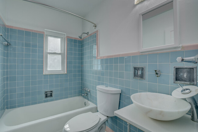
Kirby's Dreamland Photos
-
Kirby's Dreamland
-
-
-
-
-
-
-
-
Nearby Apartments
Within 50 Miles of Kirby's Dreamland
-
1221 California Ave
1221 California Ave
Cincinnati, OH 45237
$1,430 - $1,480
3 Br 3.8 mi
-
420 Chestnut St
420-422 Chestnut St
Cincinnati, OH 45203
$1,780 - $1,830
2 Br 4.5 mi
-
830 Nebraska Ave
830 Nebraska Ave
Cincinnati, OH 45238
$950
2 Br 5.0 mi
-
The Montgomeries
5729-5733 Montgomery Rd
Cincinnati, OH 45212
$880 - $930
2 Br 5.9 mi
-
3719-3721 Kirkup Ave
3719 Kirkup Ave
Cincinnati, OH 45213
$1,500
3 Br 7.4 mi
-
Washington Apartments
22 Washington Ave
North Bend, OH 45052
$895
2 Br 10.8 mi
While Kirby's Dreamland does not provide in‑unit laundry, on‑site laundry facilities are available for shared resident use.
Utilities are not included in rent. Residents should plan to set up and pay for all services separately.
Parking is available at Kirby's Dreamland. Fees may apply depending on the type of parking offered. Contact this property for details.
Kirby's Dreamland has two-bedrooms apartments renting for $1,195/mo.
Yes, Kirby's Dreamland welcomes pets. Breed restrictions, weight limits, and additional fees may apply. View this property's pet policy.
A good rule of thumb is to spend no more than 30% of your gross income on rent. Based on the lowest available rent of $1,195 for a two-bedrooms, you would need to earn about $47,800 per year to qualify. Want to double-check your budget? Calculate how much rent you can afford with our Rent Affordability Calculator.
Kirby's Dreamland is not currently offering any rent specials. Check back soon, as promotions change frequently.
While Kirby's Dreamland does not offer Matterport 3D tours, renters can request a tour directly through our online platform.
What Are Walk Score®, Transit Score®, and Bike Score® Ratings?
Walk Score® measures the walkability of any address. Transit Score® measures access to public transit. Bike Score® measures the bikeability of any address.
What is a Sound Score Rating?
A Sound Score Rating aggregates noise caused by vehicle traffic, airplane traffic and local sources

4344-4348 Kirby Ave
Cincinnati, OH 45223