
Presidential Towers
555 W Madison St,
Chicago, IL 60661
$1,615 - $9,335
Studio - 2 Beds
Bedrooms
2 bd
Bathrooms
2 ba
Square Feet
1,010 - 1,145 sq ft
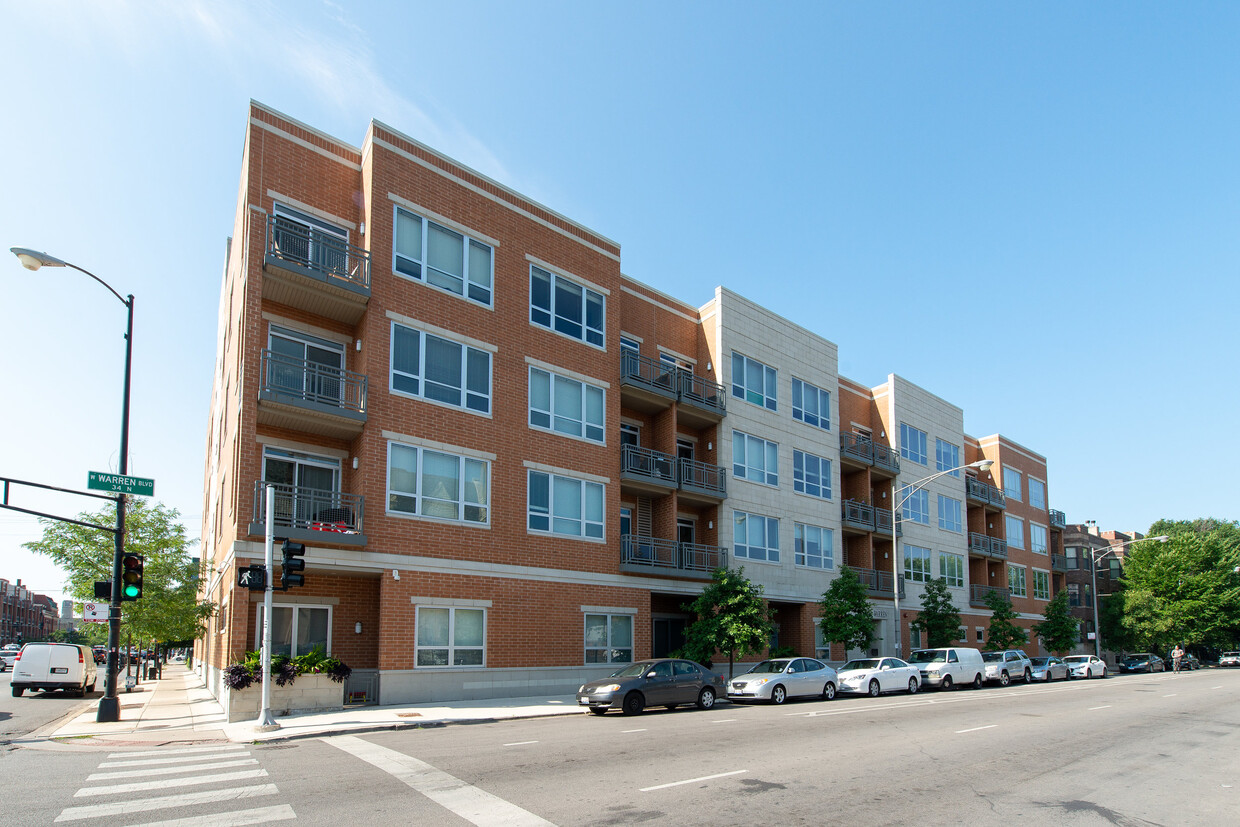
Welcome to Highpoint West Loop modern 2-bedroom apartments for rent in Chicagos vibrant West Loop neighborhood. Located at 1609 W Warren Blvd, our pet-friendly community features in-unit laundry, updated kitchens, private balconies, and hardwood floor. Live near the Blue Line, United Center, UIC, and Randolph Streets shops and restaurants. Discover urban comfort in the heart of West Loop.Discover more when you come for a visit -- call today!
Welcome to Highpoint West Loop modern 2-bedroom apartments for rent in Chicagos vibrant West Loop neighborhood. Located at 1609 W Warren Blvd, our pet-friendly community features in-unit laundry, updated kitchens, private balconies, and hardwood floor. Live near the Blue Line, United Center, UIC, and Randolph Streets shops and restaurants. Discover urban comfort in the heart of West Loop.Discover more when you come for a visit -- call today!
HIGHPOINT West Loop is an apartment community located in Cook County and the 60612 ZIP Code. This area is served by the Chicago Public Schools attendance zone.
Fitness Center
Elevator
Roof Terrace
Recycling
High Speed Internet Access
Hardwood Floors
Island Kitchen
Granite Countertops
Wi-Fi
Tub/Shower
Disposal
Ice Maker
Dotted with parks and adjacent to Interstate 290, Near West Side is the perfect neighborhood for any commuter looking for refreshing, wide-open space. Interstate 290 runs through the south side of the neighborhood, which lies roughly two miles away from Chicago's city center. Public transportation options include the Blue Line rapid transit system and several bus routes, which make it easy to get around the area. Rentals, which incorporate both modern and historic properties, cost a little more than the Chicago city average because of the neighborhood's proximity to downtown.
If you’re looking for what to do in Near Westside, look no further! United Center, home to the Chicago Bulls and the Chicago Blackhawks, sits on the neighborhood's east side. In addition to featuring basketball and hockey games, this versatile venue regularly hosts concerts and other entertainment events, making it a social hub for locals and visitors alike.
Learn more about living in Near West Side| Colleges & Universities | Distance | ||
|---|---|---|---|
| Colleges & Universities | Distance | ||
| Walk: | 10 min | 0.6 mi | |
| Walk: | 12 min | 0.6 mi | |
| Drive: | 3 min | 1.4 mi | |
| Drive: | 5 min | 1.9 mi |


Transportation options available in Chicago include Ashland Station (Green, Pink Lines), located 0.3 mile from HIGHPOINT West Loop. HIGHPOINT West Loop is near Chicago Midway International, located 9.2 miles or 16 minutes away, and Chicago O'Hare International, located 17.0 miles or 26 minutes away.
| Transit / Subway | Distance | ||
|---|---|---|---|
| Transit / Subway | Distance | ||
|
|
Walk: | 4 min | 0.3 mi |
|
|
Walk: | 12 min | 0.7 mi |
|
|
Walk: | 13 min | 0.7 mi |
|
|
Walk: | 15 min | 0.8 mi |
|
|
Drive: | 5 min | 2.6 mi |
| Commuter Rail | Distance | ||
|---|---|---|---|
| Commuter Rail | Distance | ||
|
|
Drive: | 3 min | 1.4 mi |
|
|
Drive: | 4 min | 1.6 mi |
|
|
Drive: | 4 min | 1.7 mi |
|
|
Drive: | 5 min | 2.4 mi |
|
|
Drive: | 5 min | 2.6 mi |
| Airports | Distance | ||
|---|---|---|---|
| Airports | Distance | ||
|
Chicago Midway International
|
Drive: | 16 min | 9.2 mi |
|
Chicago O'Hare International
|
Drive: | 26 min | 17.0 mi |
Time and distance from HIGHPOINT West Loop.
| Shopping Centers | Distance | ||
|---|---|---|---|
| Shopping Centers | Distance | ||
| Walk: | 17 min | 0.9 mi | |
| Drive: | 2 min | 1.2 mi | |
| Drive: | 3 min | 1.2 mi |
| Parks and Recreation | Distance | ||
|---|---|---|---|
| Parks and Recreation | Distance | ||
|
Alliance for the Great Lakes
|
Drive: | 5 min | 2.2 mi |
|
Openlands
|
Drive: | 5 min | 2.2 mi |
|
Millennium Park
|
Drive: | 5 min | 2.3 mi |
|
Douglas Park and Community Center
|
Drive: | 4 min | 2.3 mi |
|
Humboldt Park
|
Drive: | 6 min | 3.3 mi |
| Hospitals | Distance | ||
|---|---|---|---|
| Hospitals | Distance | ||
| Walk: | 10 min | 0.5 mi | |
| Walk: | 13 min | 0.7 mi | |
| Walk: | 19 min | 1.0 mi |
| Military Bases | Distance | ||
|---|---|---|---|
| Military Bases | Distance | ||
| Drive: | 34 min | 24.7 mi |
What Are Walk Score®, Transit Score®, and Bike Score® Ratings?
Walk Score® measures the walkability of any address. Transit Score® measures access to public transit. Bike Score® measures the bikeability of any address.
What is a Sound Score Rating?
A Sound Score Rating aggregates noise caused by vehicle traffic, airplane traffic and local sources

1609 W Warren Blvd
Chicago, IL 60612


