
Presidential Towers
555 W Madison St,
Chicago, IL 60661
$1,631 - $6,395
Studio - 2 Beds
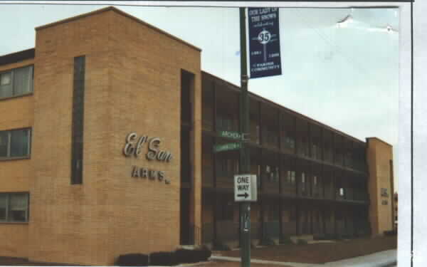

Located on Archer Ave, with conveniences of CTA, restaurants, shopping, all close by. Off street parking located in rear of building for 1 car per unit.
El San Arms is an apartment community located in Cook County and the 60638 ZIP Code. This area is served by the Chicago Public Schools attendance zone.
Air Conditioning
Refrigerator
Tub/Shower
Heating
Situated on the southwest side of Chicago, Garfield Ridge is a predominantly residential neighborhood teeming with a wide range of houses available for rent. Garfield Ridge also encompasses the northern part of the historic Midway International Airport, the world's busiest airport from the 1930s through the 1960s. The popularity of the airport has allowed Garfield Ridge to continuously grow as a community.
Archer Avenue is Garfield Ridge’s main thoroughfare, running through the center of the neighborhood with a host of diverse eateries and family-owned businesses. Garfield Ridge is home to the 15-acre Wentworth Park, where residents enjoy access to numerous athletic courts and fields as well as an ice skating rink and year-round events. Getting to Chicago’s Loop from Garfield Ridge is easy with access to the Orange Line and I-55.
Learn more about living in Garfield RidgeCompare neighborhood and city base rent averages by bedroom.
| Garfield Ridge | Chicago, IL | |
|---|---|---|
| Studio | - | $1,644 |
| 1 Bedroom | $978 | $2,046 |
| 2 Bedrooms | $1,093 | $2,581 |
| 3 Bedrooms | $1,433 | $3,091 |
| Colleges & Universities | Distance | ||
|---|---|---|---|
| Colleges & Universities | Distance | ||
| Drive: | 9 min | 4.6 mi | |
| Drive: | 17 min | 8.2 mi | |
| Drive: | 14 min | 8.4 mi | |
| Drive: | 14 min | 8.5 mi |


Transportation options available in Chicago include Pulaski Station (Orange Line), located 1.6 miles from El San Arms. El San Arms is near Chicago Midway International, located 1.5 miles or 29 minutes away, and Chicago O'Hare International, located 22.4 miles or 38 minutes away.
| Transit / Subway | Distance | ||
|---|---|---|---|
| Transit / Subway | Distance | ||
|
|
Drive: | 4 min | 1.6 mi |
|
|
Drive: | 3 min | 1.8 mi |
|
|
Drive: | 6 min | 3.0 mi |
|
|
Drive: | 7 min | 4.0 mi |
|
|
Drive: | 9 min | 4.8 mi |
| Commuter Rail | Distance | ||
|---|---|---|---|
| Commuter Rail | Distance | ||
|
|
Drive: | 7 min | 3.4 mi |
|
|
Drive: | 7 min | 4.1 mi |
|
|
Drive: | 12 min | 5.3 mi |
|
|
Drive: | 10 min | 5.4 mi |
|
|
Drive: | 11 min | 5.9 mi |
| Airports | Distance | ||
|---|---|---|---|
| Airports | Distance | ||
|
Chicago Midway International
|
Walk: | 29 min | 1.5 mi |
|
Chicago O'Hare International
|
Drive: | 38 min | 22.4 mi |
Scores provided by
Traffic
-Airport
-Businesses
-Scores provided by
HowLoud What is a Sound Score Rating? A Sound Score Rating aggregates noise caused by vehicle traffic, airplane traffic and local sources. How It WorksTime and distance from El San Arms.
| Shopping Centers | Distance | ||
|---|---|---|---|
| Shopping Centers | Distance | ||
| Walk: | 8 min | 0.4 mi | |
| Walk: | 12 min | 0.6 mi |
| Parks and Recreation | Distance | ||
|---|---|---|---|
| Parks and Recreation | Distance | ||
|
Gage Park
|
Drive: | 7 min | 3.9 mi |
|
McKinley Park
|
Drive: | 8 min | 4.3 mi |
|
Marquette Park
|
Drive: | 9 min | 4.7 mi |
|
White Eagle Woods-North
|
Drive: | 9 min | 4.8 mi |
|
White Eagle Woods-South
|
Drive: | 10 min | 4.9 mi |
| Hospitals | Distance | ||
|---|---|---|---|
| Hospitals | Distance | ||
| Drive: | 11 min | 4.7 mi | |
| Drive: | 10 min | 5.1 mi | |
| Drive: | 11 min | 6.4 mi |
| Military Bases | Distance | ||
|---|---|---|---|
| Military Bases | Distance | ||
| Drive: | 41 min | 25.5 mi | |
| Drive: | 52 min | 30.5 mi | |
| Drive: | 46 min | 32.6 mi |
What Are Walk Score®, Transit Score®, and Bike Score® Ratings?
Walk Score® measures the walkability of any address. Transit Score® measures access to public transit. Bike Score® measures the bikeability of any address.
What is a Sound Score Rating?
A Sound Score Rating aggregates noise caused by vehicle traffic, airplane traffic and local sources.

5614-5628 Archer Ave
Chicago, IL 60638


