
The Boulevard
2635 Contra Costa Blvd,
Pleasant Hill, CA 94523
$2,325 - $2,410
1 Bed

Bedrooms
1 - 2 bd
Bathrooms
1 - 2 ba
Square Feet
625 - 825 sq ft
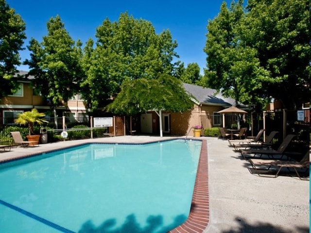
Style That Inspires. Crossroads apartment home community offers one- and two-bedroom floor plans with granite-style countertops, private patios, and energy-efficient appliances. Amenities including a resort-style pool and on-site pet park make Crossroads a place that you and your furry friend will want to call home.
Style That Inspires. Crossroads apartment home community offers one- and two-bedroom floor plans with granite-style countertops, private patios, and energy-efficient appliances. Amenities including a resort-style pool and on-site pet park make Crossroads a place that you and your furry friend will want to call home.
Crossroads is an apartment community located in Contra Costa County and the 94521 ZIP Code. This area is served by the Mt. Diablo Unified School District attendance zone.
Unique Features
Air Conditioning
Dishwasher
Patio
Ceiling Fans
The city of Concord exhibits all the character, charm, and natural beauty you’d expect of the Bay Area. South Concord, stretching from Clayton Road down towards Walnut Creek, provides renters with all of the appeal of the city in a more livable, affordable setting.
This vibrant suburban area houses a variety of rentals sandwiched between Lime Ride Open Space and Sunvalley Shopping Center. If you want value and space in a palm-tree-adorned atmopshere, look no further. Perfect for commuters thanks to I-680 to the west, South Concord provides families with a picturesque setting near the conveniences of the city, and the culture of the Bay Area.
Learn more about living in South ConcordCompare neighborhood and city base rent averages by bedroom.
| South Concord | Concord, CA | |
|---|---|---|
| Studio | $1,840 | $1,718 |
| 1 Bedroom | $1,979 | $1,934 |
| 2 Bedrooms | $2,284 | $2,274 |
| 3 Bedrooms | $2,732 | $2,837 |
| Colleges & Universities | Distance | ||
|---|---|---|---|
| Colleges & Universities | Distance | ||
| Drive: | 19 min | 7.7 mi | |
| Drive: | 17 min | 9.1 mi | |
| Drive: | 29 min | 14.1 mi | |
| Drive: | 39 min | 24.8 mi |


Transportation options available in Concord include Concord, located 4.6 miles from Crossroads. Crossroads is near Metro Oakland International, located 31.4 miles or 46 minutes away, and San Francisco International, located 43.4 miles or 65 minutes away.
| Transit / Subway | Distance | ||
|---|---|---|---|
| Transit / Subway | Distance | ||
|
|
Drive: | 11 min | 4.6 mi |
|
|
Drive: | 14 min | 6.3 mi |
|
|
Drive: | 13 min | 7.0 mi |
|
|
Drive: | 14 min | 9.3 mi |
|
|
Drive: | 17 min | 9.4 mi |
| Commuter Rail | Distance | ||
|---|---|---|---|
| Commuter Rail | Distance | ||
|
|
Drive: | 25 min | 13.0 mi |
| Drive: | 36 min | 22.8 mi | |
|
|
Drive: | 36 min | 24.5 mi |
|
|
Drive: | 38 min | 26.0 mi |
|
|
Drive: | 46 min | 31.8 mi |
| Airports | Distance | ||
|---|---|---|---|
| Airports | Distance | ||
|
Metro Oakland International
|
Drive: | 46 min | 31.4 mi |
|
San Francisco International
|
Drive: | 65 min | 43.4 mi |
Scores provided by
Traffic
-Airport
-Businesses
-Scores provided by
HowLoud What is a Sound Score Rating? A Sound Score Rating aggregates noise caused by vehicle traffic, airplane traffic and local sources. How It WorksTime and distance from Crossroads.
| Shopping Centers | Distance | ||
|---|---|---|---|
| Shopping Centers | Distance | ||
| Walk: | 1 min | 0.1 mi | |
| Walk: | 7 min | 0.4 mi | |
| Walk: | 10 min | 0.5 mi |
| Parks and Recreation | Distance | ||
|---|---|---|---|
| Parks and Recreation | Distance | ||
|
Markham Nature Park and Arboretum
|
Drive: | 8 min | 3.5 mi |
|
The Ruth Bancroft Garden
|
Drive: | 10 min | 5.5 mi |
|
Arbolado Park
|
Drive: | 12 min | 5.5 mi |
|
Castle Rock Regional Recreation Area
|
Drive: | 16 min | 6.9 mi |
|
Diablo Foothills Regional Park
|
Drive: | 18 min | 7.1 mi |
| Hospitals | Distance | ||
|---|---|---|---|
| Hospitals | Distance | ||
| Drive: | 12 min | 5.2 mi | |
| Drive: | 13 min | 5.5 mi | |
| Drive: | 11 min | 5.9 mi |
| Military Bases | Distance | ||
|---|---|---|---|
| Military Bases | Distance | ||
| Drive: | 31 min | 9.9 mi | |
| Drive: | 27 min | 15.0 mi | |
| Drive: | 46 min | 24.5 mi |
What Are Walk Score®, Transit Score®, and Bike Score® Ratings?
Walk Score® measures the walkability of any address. Transit Score® measures access to public transit. Bike Score® measures the bikeability of any address.
What is a Sound Score Rating?
A Sound Score Rating aggregates noise caused by vehicle traffic, airplane traffic and local sources.
5378 Clayton Rd
Concord, CA 94521


