
Cardinal 95
9600 W Georgia Ave,
Glendale, AZ 85305
$1,334 - $2,911
1-3 Beds


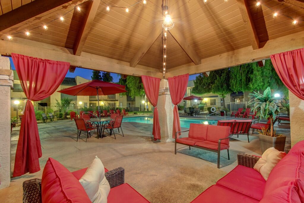
Choosing a new home can be stressful, we know. Relax. Cedar Creek had you in mind when choosing our tile, granite countertops, stainless steel appliances, and great neighbors! Join our community and enjoy all Cedar Creek has to offer.
Cedar Creek is an apartment community located in Maricopa County and the 85301 ZIP Code. This area is served by the Alhambra Elementary District attendance zone.
Pool
Fitness Center
Furnished Units Available
Clubhouse
Washer/Dryer
Air Conditioning
Dishwasher
Washer/Dryer Hookup
High Speed Internet Access
Walk-In Closets
Microwave
Refrigerator
Westside is a neighborhood within Glendale, which was voted “Arizona’s Antique Capital” by Sunset magazine and USA Today. Many higher education schools are located near Westside, including Glendale Community College, Carrington College, and Arizona State University West campus. You’ll discover numerous pocket parks in the area, plus larger ones like Glendale Heroes Regional Park and Grand Canal Linear Park. Shopping and dining destinations are plentiful, especially at Arrowhead Towne Center Mall.
Learn more about living in Westside| Colleges & Universities | Distance | ||
|---|---|---|---|
| Colleges & Universities | Distance | ||
| Drive: | 9 min | 3.5 mi | |
| Drive: | 12 min | 5.2 mi | |
| Drive: | 14 min | 6.7 mi | |
| Drive: | 16 min | 8.8 mi |


Transportation options available in Glendale include 19Th Ave/Camelback, located 5.2 miles from Cedar Creek. Cedar Creek is near Phoenix Sky Harbor International, located 14.0 miles or 24 minutes away, and Phoenix-Mesa Gateway, located 40.7 miles or 56 minutes away.
| Transit / Subway | Distance | ||
|---|---|---|---|
| Transit / Subway | Distance | ||
|
|
Drive: | 11 min | 5.2 mi |
|
|
Drive: | 12 min | 5.9 mi |
|
|
Drive: | 13 min | 6.8 mi |
|
|
Drive: | 15 min | 7.7 mi |
|
|
Drive: | 15 min | 8.7 mi |
| Commuter Rail | Distance | ||
|---|---|---|---|
| Commuter Rail | Distance | ||
|
|
Drive: | 56 min | 41.8 mi |
| Airports | Distance | ||
|---|---|---|---|
| Airports | Distance | ||
|
Phoenix Sky Harbor International
|
Drive: | 24 min | 14.0 mi |
|
Phoenix-Mesa Gateway
|
Drive: | 56 min | 40.7 mi |
Time and distance from Cedar Creek.
| Shopping Centers | Distance | ||
|---|---|---|---|
| Shopping Centers | Distance | ||
| Walk: | 2 min | 0.0 mi | |
| Walk: | 7 min | 0.4 mi | |
| Walk: | 14 min | 0.7 mi |
| Parks and Recreation | Distance | ||
|---|---|---|---|
| Parks and Recreation | Distance | ||
|
Maryvale Park
|
Drive: | 3 min | 1.5 mi |
|
El Oso Park
|
Drive: | 8 min | 3.9 mi |
|
Steele Indian School Park
|
Drive: | 14 min | 7.0 mi |
|
Japanese Friendship Garden
|
Drive: | 15 min | 7.6 mi |
|
Colter Park
|
Drive: | 14 min | 7.7 mi |
| Hospitals | Distance | ||
|---|---|---|---|
| Hospitals | Distance | ||
| Drive: | 11 min | 5.6 mi | |
| Drive: | 12 min | 5.6 mi | |
| Drive: | 12 min | 6.2 mi |
| Military Bases | Distance | ||
|---|---|---|---|
| Military Bases | Distance | ||
| Drive: | 21 min | 11.7 mi | |
| Drive: | 24 min | 13.8 mi | |
| Drive: | 96 min | 70.7 mi |
What Are Walk Score®, Transit Score®, and Bike Score® Ratings?
Walk Score® measures the walkability of any address. Transit Score® measures access to public transit. Bike Score® measures the bikeability of any address.
What is a Sound Score Rating?
A Sound Score Rating aggregates noise caused by vehicle traffic, airplane traffic and local sources
5039 N 57th Ave
Glendale, AZ 85301


