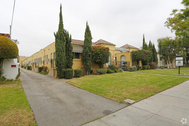
cal112
1121-1125 E California Ave,
Glendale,
CA
91206
-
Monthly Rent
$1,795
-
Bedrooms
1 bd
-
Bathrooms
1 ba
-
Square Feet
417 sq ft
Experience Glendale living at cal112. This property is situated on E California Ave in the Citrus Grove area of Glendale. From amenities to floor plan options, the leasing team will assist you in finding your ideal place. Make your move to cal112. Contact us or stop in to discuss your new apartment.
Pricing & Floor Plans
-
Unit 1121-Cprice $1,795square feet 417availibility Now
-
Unit 1121-Cprice $1,795square feet 417availibility Now
Fees and Policies
The fees below are based on community-supplied data and may exclude additional fees and utilities.
- Cats Allowed
-
Fees not specified
-
Weight limit--
-
Pet Limit--
Details
Lease Options
-
12 mo
Property Information
-
Built in 1926
-
22 units/1 story
About cal112
Experience Glendale living at cal112. This property is situated on E California Ave in the Citrus Grove area of Glendale. From amenities to floor plan options, the leasing team will assist you in finding your ideal place. Make your move to cal112. Contact us or stop in to discuss your new apartment.
cal112 is an apartment community located in Los Angeles County and the 91206 ZIP Code. This area is served by the Glendale Unified attendance zone.
Unique Features
- Birds-Maximum 2 birds
Contact
Community Amenities
- Laundry Facilities
Apartment Features
- Air Conditioning
- Balcony
- Laundry Facilities
- Birds-Maximum 2 birds
- Air Conditioning
- Balcony
| Monday | By Appointment |
|---|---|
| Tuesday | By Appointment |
| Wednesday | By Appointment |
| Thursday | By Appointment |
| Friday | By Appointment |
| Saturday | By Appointment |
| Sunday | By Appointment |
Located in the San Fernando Valley, Citrus Grove allows residents to enjoy some of the best Glendale and Los Angeles County has to offer. This palm-tree-lined, family-friendly neighborhood has excellent schools, several parks, and access to plenty of amenities. Along with its own restaurants and stores, Citrus Grove is only a mile east of Downtown Glendale, so residents live within minutes of a plethora of dining and shopping options, including Glendale Galleria and the Americana at Brand. Highways 2 and 32 connect the Citrus Grove neighborhood with Interstate 5, allowing trips up and down California in all directions, whether the aim is Los Angeles or the coast. The neighborhood is convenient to multiple local favorites including Dodger Stadium and the iconic Griffith Park. Complemented by views of the Verdugo Mountains, Citrus Grove has Mediterranean-style apartments, condos, townhouses, and houses available for rent.
Learn more about living in Citrus Grove| Colleges & Universities | Distance | ||
|---|---|---|---|
| Colleges & Universities | Distance | ||
| Drive: | 3 min | 1.6 mi | |
| Drive: | 7 min | 3.2 mi | |
| Drive: | 13 min | 6.7 mi | |
| Drive: | 14 min | 7.3 mi |


View GreatSchools Rating Methodology
Data provided by GreatSchools.org © 2025. All rights reserved.
Transportation options available in Glendale include Southwest Museum Station, located 5.2 miles from cal112. cal112 is near Bob Hope, located 11.3 miles or 17 minutes away, and Los Angeles International, located 23.2 miles or 37 minutes away.
| Transit / Subway | Distance | ||
|---|---|---|---|
| Transit / Subway | Distance | ||
|
|
Drive: | 11 min | 5.2 mi |
|
|
Drive: | 11 min | 5.7 mi |
|
|
Drive: | 11 min | 5.9 mi |
|
|
Drive: | 11 min | 6.5 mi |
|
|
Drive: | 13 min | 7.4 mi |
| Commuter Rail | Distance | ||
|---|---|---|---|
| Commuter Rail | Distance | ||
|
|
Drive: | 6 min | 2.8 mi |
|
|
Drive: | 9 min | 5.8 mi |
|
|
Drive: | 13 min | 8.5 mi |
|
|
Drive: | 17 min | 8.8 mi |
|
|
Drive: | 15 min | 9.2 mi |
| Airports | Distance | ||
|---|---|---|---|
| Airports | Distance | ||
|
Bob Hope
|
Drive: | 17 min | 11.3 mi |
|
Los Angeles International
|
Drive: | 37 min | 23.2 mi |
Time and distance from cal112.
| Shopping Centers | Distance | ||
|---|---|---|---|
| Shopping Centers | Distance | ||
| Walk: | 5 min | 0.3 mi | |
| Walk: | 7 min | 0.4 mi | |
| Walk: | 10 min | 0.6 mi |
| Parks and Recreation | Distance | ||
|---|---|---|---|
| Parks and Recreation | Distance | ||
|
Elyria Canyon Park
|
Drive: | 10 min | 4.4 mi |
|
Marsh Park
|
Drive: | 10 min | 5.1 mi |
|
Los Angeles Zoo
|
Drive: | 15 min | 5.3 mi |
|
Bird Sanctuary
|
Drive: | 12 min | 5.4 mi |
|
Griffith Park
|
Drive: | 25 min | 8.9 mi |
| Hospitals | Distance | ||
|---|---|---|---|
| Hospitals | Distance | ||
| Walk: | 14 min | 0.7 mi | |
| Drive: | 5 min | 2.6 mi | |
| Drive: | 8 min | 4.8 mi |
| Military Bases | Distance | ||
|---|---|---|---|
| Military Bases | Distance | ||
| Drive: | 34 min | 24.8 mi |
Property Ratings at cal112
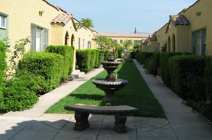
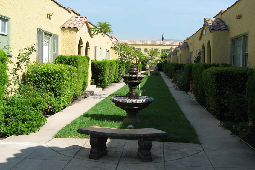
I love this apartment and apartment complex as a good starting out apartment. The price could match the amenities, aesthetics, and square footage of the unit a little more, but overall the apartment has been great. There is no central AC, due to the building being an old building; however, there is an AC unit added into the bedrooms. The living room tends to get really, and I mean really, hot during the summer time because some of them face the direction of the sun setting. The security of the apartment and building are great, with a beautiful courtyard that runs down the middle of the building and all the entrances have a gate so it feels secure. If you're looking for character in your home then this place is for you. Additionally, the on-site apartment manager is great, and is always prompt with any concerns or repairs. It has been great living here.
I think my apartment building is great. Really old complex, nice hardwood floors, really good sized kitchen. The on-site manager is great and very responsive. But because it's an old building, there are a few annoying things. There are only really two outlets in each room. No overhead lighting in the bedroom, just nice built in lamps. And the closets are a little small.
cal112 Photos
-
cal112
-
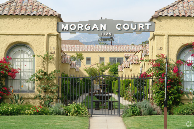
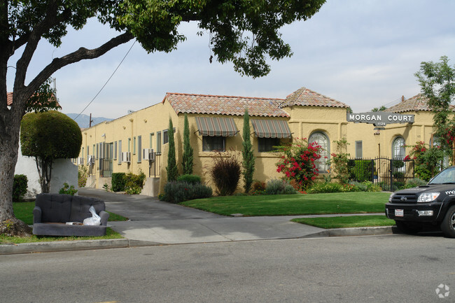
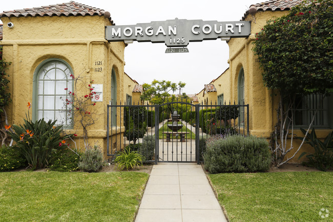
Morgan Court
-
Morgan Court
-
-
cal112
-
Morgan Court
-
-
-
Nearby Apartments
Within 50 Miles of cal112
View More Communities-
bur420
420 Burchett St
Glendale, CA 91203
$2,000 - $2,350
1-2 Br 1.3 mi
-
wil620
620 W Wilson Ave
Glendale, CA 91203
$2,750
2 Br 1.6 mi
-
ced312
312 E Cedar Ave
Burbank, CA 91502
$2,450
2 Br 3.9 mi
-
hon272
2722 Honolulu Ave
La Crescenta, CA 91214
Call for Rent
3 Br 4.2 mi
-
1207 Huntington
1207 Huntington Dr
South Pasadena, CA 91030
$2,145 - $2,650
1-2 Br 6.0 mi
-
bro411
411 E Broadway
San Gabriel, CA 91776
$2,145
1 Br 9.0 mi
cal112 has one bedroom available with rent ranges from $1,795/mo. to $1,795/mo.
Yes, to view the floor plan in person, please schedule a personal tour.
cal112 is in Citrus Grove in the city of Glendale. Here you’ll find three shopping centers within 0.6 mile of the property. Five parks are within 8.9 miles, including Marsh Park, Elyria Canyon Park, and Bird Sanctuary.
What Are Walk Score®, Transit Score®, and Bike Score® Ratings?
Walk Score® measures the walkability of any address. Transit Score® measures access to public transit. Bike Score® measures the bikeability of any address.
What is a Sound Score Rating?
A Sound Score Rating aggregates noise caused by vehicle traffic, airplane traffic and local sources
1121-1125 E California Ave
Glendale, CA 91206
Responded To This Review