
Carlton Apartments
125 W Farrell Ave,
Ewing, NJ 08618
$1,645 - $2,470
1-2 Beds

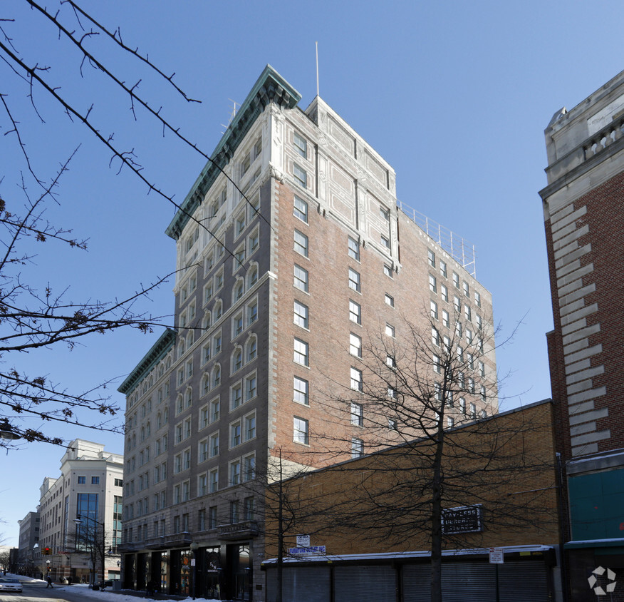
Discover your new home at Broad Street Bank Apartments. This community is located at 143-153 E State St in Trenton. The professional leasing staff is ready to help you find your dream apartment. Experience a better way of living at Broad Street Bank Apartments. Contact us or stop by the leasing office to learn more about our community.
Broad Street Bank Apartments is an apartment community located in Mercer County and the 08608 ZIP Code. This area is served by the Trenton Public attendance zone.
Air Conditioning
Dishwasher
High Speed Internet Access
Hardwood Floors
Mill Hill is a historic neighborhood with a strong sense of community, located within walking distance of Downtown Trenton. Tree-lined streets and red brick row houses are Mill Hill’s signature, which contribute to the neighborhood’s historic charm.
Mill Hill residents enjoy convenience to Trenton’s vibrant restaurant and bar scene teeming with diverse cuisine, a regionally recognized theater scene, and numerous entertainment venues. The CURE Insurance Arena is also just two blocks away from Mill Hill, hosting a wide variety of performances year round.
New York City and Philadelphia are both within easy commuting distance from Mill Hill. The Jersey Shore is less than an hour’s drive away while Baltimore and Washington make for perfect day trips. Convenient to numerous major roadways, Mill Hill is just a seven-minute walk from the Trenton Transit Center, which services NJ Transit, SEPTA, and Amtrak.
Learn more about living in Mill Hill| Colleges & Universities | Distance | ||
|---|---|---|---|
| Colleges & Universities | Distance | ||
| Walk: | 3 min | 0.2 mi | |
| Drive: | 10 min | 4.1 mi | |
| Drive: | 11 min | 5.4 mi | |
| Drive: | 19 min | 8.1 mi |


Transportation options available in Trenton include Trenton, located 0.6 mile from Broad Street Bank Apartments. Broad Street Bank Apartments is near Trenton Mercer, located 5.9 miles or 12 minutes away, and Philadelphia International, located 43.1 miles or 63 minutes away.
| Transit / Subway | Distance | ||
|---|---|---|---|
| Transit / Subway | Distance | ||
|
|
Walk: | 10 min | 0.6 mi |
|
|
Walk: | 18 min | 1.0 mi |
|
|
Drive: | 6 min | 3.0 mi |
|
|
Drive: | 14 min | 7.3 mi |
|
|
Drive: | 18 min | 10.8 mi |
| Commuter Rail | Distance | ||
|---|---|---|---|
| Commuter Rail | Distance | ||
| Walk: | 11 min | 0.6 mi | |
|
|
Walk: | 11 min | 0.6 mi |
|
|
Drive: | 8 min | 4.2 mi |
|
|
Drive: | 9 min | 4.5 mi |
|
|
Drive: | 10 min | 4.7 mi |
| Airports | Distance | ||
|---|---|---|---|
| Airports | Distance | ||
|
Trenton Mercer
|
Drive: | 12 min | 5.9 mi |
|
Philadelphia International
|
Drive: | 63 min | 43.1 mi |
Time and distance from Broad Street Bank Apartments.
| Shopping Centers | Distance | ||
|---|---|---|---|
| Shopping Centers | Distance | ||
| Walk: | 19 min | 1.0 mi | |
| Drive: | 2 min | 1.1 mi | |
| Drive: | 3 min | 1.4 mi |
| Parks and Recreation | Distance | ||
|---|---|---|---|
| Parks and Recreation | Distance | ||
|
New Jersey State Museum Planetarium
|
Walk: | 10 min | 0.6 mi |
|
Drexel Woods Park
|
Drive: | 6 min | 3.4 mi |
|
Lawrence Nature Center
|
Drive: | 6 min | 3.4 mi |
|
Sayen House & Gardens
|
Drive: | 15 min | 6.7 mi |
|
Fernbrook Farms
|
Drive: | 15 min | 9.0 mi |
| Hospitals | Distance | ||
|---|---|---|---|
| Hospitals | Distance | ||
| Drive: | 3 min | 1.3 mi | |
| Drive: | 2 min | 1.5 mi | |
| Drive: | 19 min | 11.2 mi |
| Military Bases | Distance | ||
|---|---|---|---|
| Military Bases | Distance | ||
| Drive: | 30 min | 19.1 mi | |
| Drive: | 35 min | 20.5 mi |
What Are Walk Score®, Transit Score®, and Bike Score® Ratings?
Walk Score® measures the walkability of any address. Transit Score® measures access to public transit. Bike Score® measures the bikeability of any address.
What is a Sound Score Rating?
A Sound Score Rating aggregates noise caused by vehicle traffic, airplane traffic and local sources
143-153 E State St
Trenton, NJ 08608


