
The Julian
419 Melwood Ave,
Pittsburgh, PA 15213
$1,875 - $3,250
Studio - 2 Beds

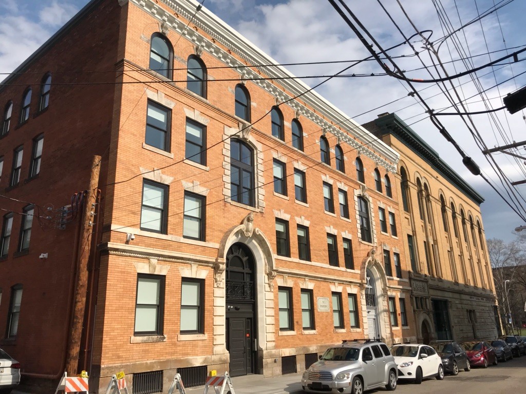
This four-story Renaissance Revival apartment building replaced four clapboarded flats at the corner of Reddour and Eloise Streets. Prominent Pittsburgh architect, Frederick Osterling (Union Trust Building downtown, Armstrong Cork Building in the Strip District, now Cork Factor Lofts) designed the building circa 1905. William T. Bradberry, President of the Anshutz-Bradberry Stove Company, located in Allegheny City, owned the building. Please call 412-231-2001 to set up a showing or ask any questions you may have! Please feel free to email the property Manager Gemma: glabella@trekdevelopment.com
Bradberry is an apartment community located in Allegheny County and the 15212 ZIP Code. This area is served by the Pittsburgh Public Schools attendance zone.
Washer/Dryer
Air Conditioning
Dishwasher
Microwave
National publications constantly place Pittsburgh near the top of the list for most livable cities in America, and it’s easy to see why. The city has a rich history as an industrial and economic hub, which led to the construction of many grand buildings and public sculptures which still stand today. Downtown in particular is rich with beautifully preserved buildings and lush public parks dating back well over a century, giving the entire community a timeless atmosphere.
Pittsburgh is split into three sections by the rivers passing through the city: Downtown (a.k.a. “The Golden Triangle), the North Side, and the South Side. Each has its fair share of attractions and landmarks: the North Side is home to Acrisure Stadium and PNC Park (making it a perfect area for sports fans), the South Side features big, beautiful greenways and refurbished steel mills, and Downtown is where you’ll find the most variety in dining, nightlife, and entertainment.
Learn more about living in Pittsburgh| Colleges & Universities | Distance | ||
|---|---|---|---|
| Colleges & Universities | Distance | ||
| Walk: | 13 min | 0.7 mi | |
| Drive: | 4 min | 1.5 mi | |
| Drive: | 5 min | 1.7 mi | |
| Drive: | 6 min | 2.1 mi |


Transportation options available in Pittsburgh include North Side Station, located 0.7 mile from Bradberry. Bradberry is near Pittsburgh International, located 18.6 miles or 28 minutes away, and Arnold Palmer Regional, located 44.7 miles or 70 minutes away.
| Transit / Subway | Distance | ||
|---|---|---|---|
| Transit / Subway | Distance | ||
| Walk: | 13 min | 0.7 mi | |
| Drive: | 3 min | 1.2 mi | |
|
|
Drive: | 3 min | 1.3 mi |
|
|
Drive: | 3 min | 1.4 mi |
|
|
Drive: | 4 min | 1.6 mi |
| Commuter Rail | Distance | ||
|---|---|---|---|
| Commuter Rail | Distance | ||
|
|
Drive: | 4 min | 1.6 mi |
|
|
Drive: | 54 min | 35.3 mi |
|
|
Drive: | 66 min | 41.7 mi |
| Airports | Distance | ||
|---|---|---|---|
| Airports | Distance | ||
|
Pittsburgh International
|
Drive: | 28 min | 18.6 mi |
|
Arnold Palmer Regional
|
Drive: | 70 min | 44.7 mi |
Time and distance from Bradberry.
| Shopping Centers | Distance | ||
|---|---|---|---|
| Shopping Centers | Distance | ||
| Walk: | 14 min | 0.8 mi | |
| Drive: | 5 min | 1.9 mi | |
| Drive: | 6 min | 2.1 mi |
| Parks and Recreation | Distance | ||
|---|---|---|---|
| Parks and Recreation | Distance | ||
|
National Aviary
|
Walk: | 5 min | 0.3 mi |
|
Allegheny Commons Park
|
Walk: | 7 min | 0.4 mi |
|
Children's Museum of Pittsburgh
|
Walk: | 7 min | 0.4 mi |
|
Carnegie Science Center
|
Drive: | 4 min | 1.5 mi |
|
Point State Park
|
Drive: | 4 min | 1.5 mi |
| Hospitals | Distance | ||
|---|---|---|---|
| Hospitals | Distance | ||
| Walk: | 5 min | 0.3 mi | |
| Drive: | 6 min | 2.2 mi | |
| Drive: | 9 min | 4.0 mi |
| Military Bases | Distance | ||
|---|---|---|---|
| Military Bases | Distance | ||
| Drive: | 24 min | 17.0 mi |
What Are Walk Score®, Transit Score®, and Bike Score® Ratings?
Walk Score® measures the walkability of any address. Transit Score® measures access to public transit. Bike Score® measures the bikeability of any address.
What is a Sound Score Rating?
A Sound Score Rating aggregates noise caused by vehicle traffic, airplane traffic and local sources
1112 Reddour St
Pittsburgh, PA 15212


