

$6,495
/ Month
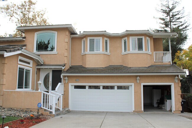
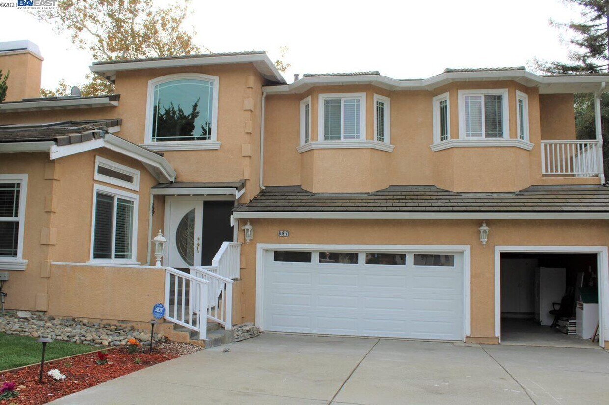
997 Scorpion Pl
Fremont, CA 94539
2 Weeks Ago
|
Edit
Favorites
997 Scorpion Pl

Favorites
Check Back Soon for Upcoming Availability
| Beds | Baths | Average SF |
|---|---|---|
| 6 Bedrooms 6 Bedrooms 6 Br | 5.5 Baths 5.5 Baths 5.5 Ba | 4,379 SF |
About This Property
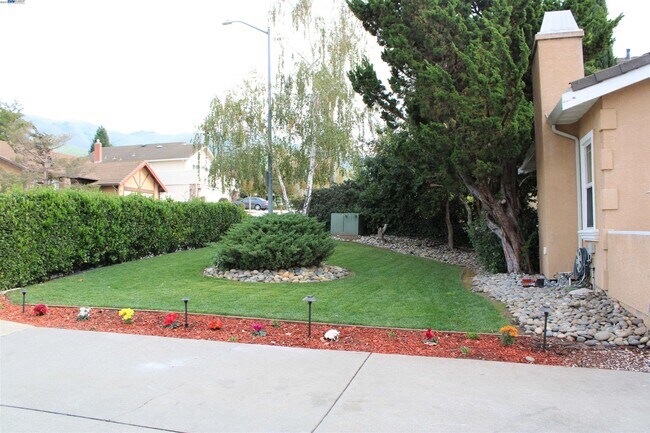
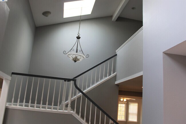
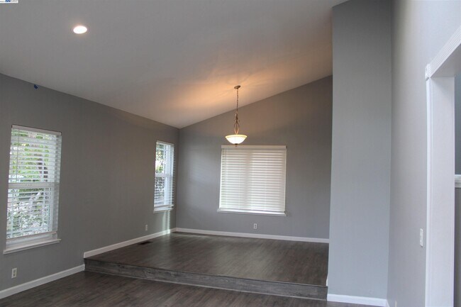
IMMACULATE 6BD,5.5 BA, 3 CAR GARAGE, PRESTIGOUS MISSION /WEIBEL AREA, RECENTLY REMODELLED, 2BD 1.5 BA DOWNSTAIRS EXCELLENT SCHOOLS, WEIBEL ELEMENTRY, HORNER JR HIGH AND IRVININGTON HIGH. EASY COMMUTE TO NEW FREMONT BART STATION,TESLA,680,880 AND SILICON VALLEY
997 Scorpion Pl is a house located in Alameda County and the 94539 ZIP Code. This area is served by the Fremont Unified attendance zone.
Location
Get Directions
Fremont, positioned in the San Francisco Bay Area, combines suburban living with innovation and technology. As home to the Tesla Factory, the city maintains a strong industrial presence while offering numerous parks and outdoor spaces. Lake Elizabeth in Central Park provides recreational opportunities, while Mission Peak's trails showcase panoramic Bay Area views. The rental market remains competitive, with average rents ranging from $2,204 for studios to $3,770 for three-bedroom homes, with year-over-year increases between 1.5% and 4.4%.
The city's five districts each offer distinct characteristics. Historic Niles preserves its early film industry heritage, while Mission San Jose features the restored Mission San José, an architectural landmark from 1797. The Warm Springs area has developed into a technology center, and Central Fremont includes shopping destinations like the Fremont Hub and Pacific Commons.
Learn more about living in FremontBelow are rent ranges for similar nearby apartments
Education
| Colleges & Universities | Distance | ||
|---|---|---|---|
| Colleges & Universities | Distance | ||
| Drive: | 6 min | 2.7 mi | |
| Drive: | 12 min | 7.3 mi | |
| Drive: | 14 min | 9.3 mi | |
| Drive: | 20 min | 14.0 mi |
997 Scorpion Pl is within 6 minutes or 2.7 miles from Ohlone College, Fremont Campus. It is also near Ohlone College, Newark and Palmer College of Chiropractic West Campus.
Schools


Public Elementary School
Grades K-5
343 Students
Nearby
Public Elementary School
Grades K-5
461 Students
Attendance Zone
Public Middle School
Grades 6-8
1,562 Students
Attendance Zone
Public High School
Grades 9-12
2,207 Students
Attendance Zone
Private Elementary School
Grades PK-6
231 Students
Nearby
Private Elementary School
Grades K
Nearby
Private Elementary, Middle & High School
Grades 2-12
Nearby
School data provided by
 The GreatSchools Rating helps parents compare schools within a state based on a variety of school quality indicators and provides a helpful picture of how effectively each school serves all of its students. Ratings are on a scale of 1 (below average) to 10 (above average) and can include test scores, college readiness, academic progress, advanced courses, equity, discipline and attendance data. We also advise parents to visit schools, consider other information on school performance and programs, and consider family needs as part of the school selection process.
View GreatSchools Rating Methodology
Data provided by GreatSchools.org © 2026. All rights reserved.
View GreatSchools Rating Methodology
Data provided by GreatSchools.org © 2026. All rights reserved.
Transportation options available in Fremont include Warm Springs / South Fremont, located 2.3 miles from 997 Scorpion Pl. 997 Scorpion Pl is near Norman Y Mineta San Jose International, located 13.3 miles or 18 minutes away, and Metro Oakland International, located 26.9 miles or 35 minutes away.
| Transit / Subway | Distance | ||
|---|---|---|---|
| Transit / Subway | Distance | ||
|
|
Drive: | 5 min | 2.3 mi |
|
|
Drive: | 14 min | 7.6 mi |
|
|
Drive: | 15 min | 7.7 mi |
|
|
Drive: | 12 min | 7.8 mi |
| Drive: | 13 min | 8.2 mi |
| Commuter Rail | Distance | ||
|---|---|---|---|
| Commuter Rail | Distance | ||
| Drive: | 14 min | 9.8 mi | |
| Drive: | 15 min | 10.0 mi | |
| Drive: | 15 min | 10.9 mi | |
| Drive: | 19 min | 13.9 mi | |
| Drive: | 21 min | 14.0 mi |
| Airports | Distance | ||
|---|---|---|---|
| Airports | Distance | ||
|
Norman Y Mineta San Jose International
|
Drive: | 18 min | 13.3 mi |
|
Metro Oakland International
|
Drive: | 35 min | 26.9 mi |
Time and distance from 997 Scorpion Pl.
| Shopping Centers | Distance | ||
|---|---|---|---|
| Shopping Centers | Distance | ||
| Drive: | 4 min | 1.6 mi | |
| Drive: | 4 min | 1.7 mi | |
| Drive: | 4 min | 1.9 mi |
997 Scorpion Pl has 3 shopping centers within 1.9 miles, which is about a 4-minute drive. The miles and minutes will be for the farthest away property.
| Parks and Recreation | Distance | ||
|---|---|---|---|
| Parks and Recreation | Distance | ||
|
Mission Peak Regional Preserve
|
Drive: | 22 min | 7.3 mi |
|
Central Park (Lake Elizabeth)
|
Drive: | 14 min | 7.7 mi |
|
Alviso Marina County Park
|
Drive: | 14 min | 9.5 mi |
|
Ed Levin County Park
|
Drive: | 18 min | 9.7 mi |
|
Sunol Regional Wilderness
|
Drive: | 30 min | 15.7 mi |
997 Scorpion Pl has 5 parks within 15.7 miles, including Mission Peak Regional Preserve, Central Park (Lake Elizabeth), and Sunol Regional Wilderness.
| Hospitals | Distance | ||
|---|---|---|---|
| Hospitals | Distance | ||
| Drive: | 12 min | 7.0 mi | |
| Drive: | 14 min | 7.9 mi | |
| Drive: | 15 min | 11.6 mi |
997 Scorpion Pl has 3 hospitals within 11.6 miles, the nearest is Kaiser Foundation Hospital - Fremont which is 7.0 miles away and a 12 minute drive.
| Military Bases | Distance | ||
|---|---|---|---|
| Military Bases | Distance | ||
| Drive: | 24 min | 16.1 mi |
997 Scorpion Pl is 16.1 miles and a 24 minute drive from Ames Research Center.
You May Also Like
Similar Rentals Nearby


What Are Walk Score®, Transit Score®, and Bike Score® Ratings?
Walk Score® measures the walkability of any address. Transit Score® measures access to public transit. Bike Score® measures the bikeability of any address.
What is a Sound Score Rating?
A Sound Score Rating aggregates noise caused by vehicle traffic, airplane traffic and local sources
997 Scorpion Pl
Fremont, CA 94539