
$5,900
Total Monthly Price
12 Month Lease
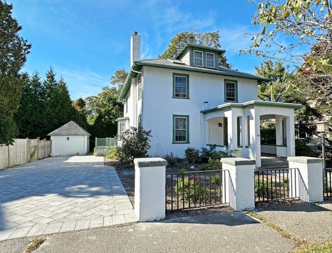
99 Hancock St
Auburndale, MA 02466
Today
Favorites
-
Bedrooms
4
-
Bathrooms
2.5
-
Square Feet
2,500 sq ft
-
Available
Available Now
Highlights
- Pets Allowed
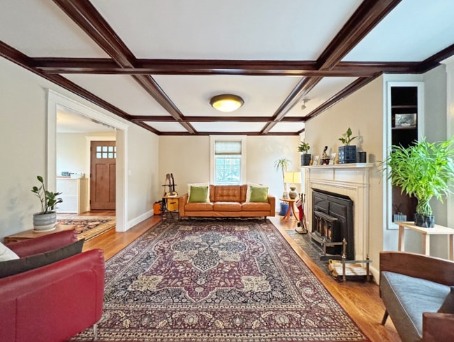
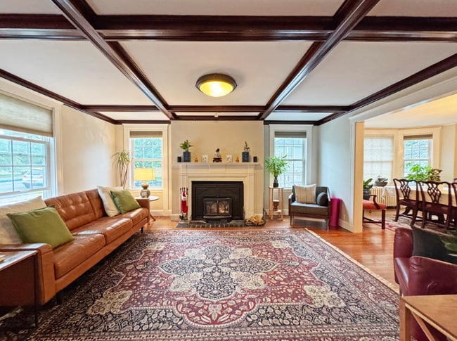
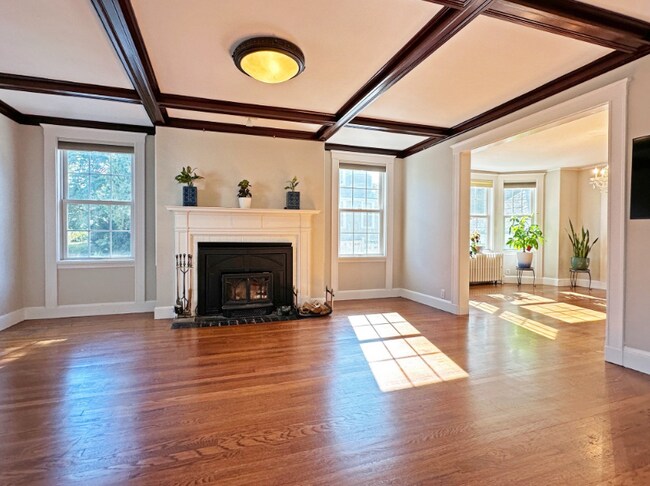
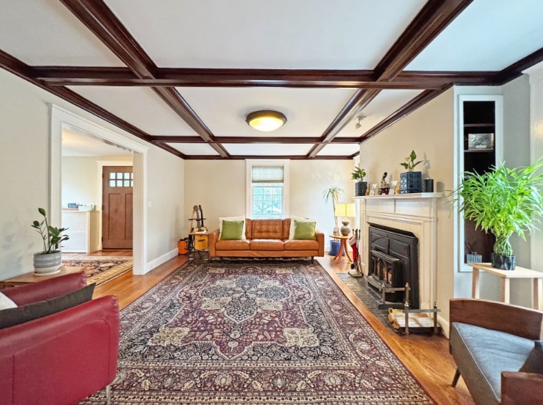
- Hardwood Floors
- Fireplace
- Deck
- Vaulted Ceiling
- Skylights
99 Hancock St

Favorites
About This Home
12 Month Lease
,
Available Now
Stucco Colonial in Auburndale across from Williams Elem. Location is perfect for commuting. Easy access to the MA Pike & 95 exits as well as walkable to the Commuter Rail, 558 bus, Star Market and the many shops & yummy restaurants in Aub Sq. Large, elegant foyer leads to charming LR featuring beamed ceiling & fireplace. Formal DR with hardwood floors throughout the home. Inviting granite kit has top notch appliances (French door fridge, Viking oven), breakfast island & plenty of cabinets and laundry area. Family room off kitchen w/ sliders to deck for outdoor entertaining. Primary BR features vaulted ceilings & skylights. Lots of windows keep the house bright all day. Huge finished bsmt with many possibilities. Beautiful wide driveway pkg for 4+ cars. Williams, Brown & South schools.
99 Hancock St is a house located in Middlesex County and the 02466 ZIP Code. This area is served by the Newton attendance zone.
* Price shown is total price based on community-supplied monthly required fees. Excludes user-selected optional fees and variable or usage-based fees and required charges due at or prior to move-in or at move-out. Price, availability, fees, and any applicable rent special are subject to change without notice.
* Square footage definitions vary. Displayed square footage is approximate.
House Features
Washer/Dryer
Hardwood Floors
Refrigerator
Fireplace
- Washer/Dryer
- Fireplace
- Kitchen
- Oven
- Refrigerator
- Hardwood Floors
- Family Room
- Vaulted Ceiling
- Skylights
- Deck
Fees and Policies
The fees below are based on community-supplied data and may exclude additional fees and utilities.
- Dogs Allowed
-
Fees not specified
- Cats Allowed
-
Fees not specified
Contact
- Contact
Location
Get Directions
Auburndale, affectionately referred to as “The Dale” by locals, is one of 13 villages in the City of Newton. Situated near the intersection of Interstates 90 and 95, the Dale is surrounded by the City of Waltham and the Charles River as well as three other Newton villages including West Newton, Waban, and Newton Lower Falls. Getting around from the Dale is simple with access to the MBTA commuter rail.
The western end of Auburndale is well known for containing two historic parks, Norumbega Park and the Auburndale Cove Park and Playground, which offer plenty of options for outdoor recreation. The Auburndale Historic District is comprised of about 275 properties, many of which are on the National Register of Historic Places. Treasured resources like the Auburndale Community Library and Lasell College provide learning opportunities for the community.
Learn more about living in Auburndale
Education
| Colleges & Universities | Distance | ||
|---|---|---|---|
| Colleges & Universities | Distance | ||
| Drive: | 7 min | 2.7 mi | |
| Drive: | 10 min | 4.3 mi | |
| Drive: | 11 min | 4.8 mi | |
| Drive: | 10 min | 5.2 mi |
99 Hancock St is within 7 minutes or 2.7 miles from Brandeis University. It is also near Bentley University and Babson College.
Schools


Public Elementary School
Grades K-5
231 Students
Attendance Zone
Public Elementary School
Grades PK-5
383 Students
Nearby
Public Middle School
Grades 6-8
750 Students
Attendance Zone
Public High School
Grades 9-12
1,837 Students
Attendance Zone
Private Elementary, Middle & High School
Grades 3-12
161 Students
Nearby
Private Elementary & Middle School
Grades PK-8
320 Students
Nearby
School data provided by
 The GreatSchools Rating helps parents compare schools within a state based on a variety of school quality indicators and provides a helpful picture of how effectively each school serves all of its students. Ratings are on a scale of 1 (below average) to 10 (above average) and can include test scores, college readiness, academic progress, advanced courses, equity, discipline and attendance data. We also advise parents to visit schools, consider other information on school performance and programs, and consider family needs as part of the school selection process.
View GreatSchools Rating Methodology
Data provided by GreatSchools.org © 2025. All rights reserved.
View GreatSchools Rating Methodology
Data provided by GreatSchools.org © 2025. All rights reserved.
Transportation options available in Auburndale include Riverside Station, located 0.5 mile from 99 Hancock St. 99 Hancock St is near General Edward Lawrence Logan International, located 14.2 miles or 23 minutes away, and Worcester Regional, located 38.5 miles or 55 minutes away.
| Transit / Subway | Distance | ||
|---|---|---|---|
| Transit / Subway | Distance | ||
|
|
Walk: | 10 min | 0.5 mi |
|
|
Drive: | 4 min | 1.3 mi |
|
|
Drive: | 6 min | 2.7 mi |
|
|
Drive: | 8 min | 3.4 mi |
|
|
Drive: | 8 min | 3.9 mi |
| Commuter Rail | Distance | ||
|---|---|---|---|
| Commuter Rail | Distance | ||
|
|
Drive: | 5 min | 2.2 mi |
|
|
Drive: | 5 min | 2.3 mi |
| Drive: | 6 min | 2.6 mi | |
|
|
Drive: | 11 min | 6.4 mi |
|
|
Drive: | 12 min | 7.2 mi |
| Airports | Distance | ||
|---|---|---|---|
| Airports | Distance | ||
|
General Edward Lawrence Logan International
|
Drive: | 23 min | 14.2 mi |
|
Worcester Regional
|
Drive: | 55 min | 38.5 mi |
Time and distance from 99 Hancock St.
| Shopping Centers | Distance | ||
|---|---|---|---|
| Shopping Centers | Distance | ||
| Walk: | 11 min | 0.6 mi | |
| Drive: | 5 min | 2.1 mi | |
| Drive: | 5 min | 2.4 mi |
99 Hancock St has 3 shopping centers within 2.4 miles, which is about a 5-minute walk. The miles and minutes will be for the farthest away property.
| Parks and Recreation | Distance | ||
|---|---|---|---|
| Parks and Recreation | Distance | ||
|
Land's Sake Farm
|
Drive: | 8 min | 3.2 mi |
|
Hemlock Gorge Reservation
|
Drive: | 9 min | 4.2 mi |
|
Hammond Pond Reservation
|
Drive: | 10 min | 4.6 mi |
|
Cutler Park Reservation
|
Drive: | 9 min | 4.9 mi |
|
Beaver Brook Reservation
|
Drive: | 10 min | 4.9 mi |
99 Hancock St has 5 parks within 4.9 miles, including Land's Sake Farm, Hemlock Gorge Reservation, and Hammond Pond Reservation.
| Hospitals | Distance | ||
|---|---|---|---|
| Hospitals | Distance | ||
| Drive: | 3 min | 1.3 mi | |
| Drive: | 6 min | 2.7 mi | |
| Drive: | 11 min | 5.3 mi |
99 Hancock St has 3 hospitals within 5.3 miles, the nearest is Newton - Wellesley Hospital which is 1.3 miles away and a 3 minute drive.
| Military Bases | Distance | ||
|---|---|---|---|
| Military Bases | Distance | ||
| Drive: | 16 min | 8.3 mi | |
| Drive: | 19 min | 9.8 mi |
99 Hancock St is 8.3 miles from US Military Reservation, and is convenient to other military bases, including Hanscom Air Force Base.
Amenities
- Washer/Dryer
- Fireplace
- Kitchen
- Oven
- Refrigerator
- Hardwood Floors
- Family Room
- Vaulted Ceiling
- Skylights
- Deck
99 Hancock St Photos
What Are Walk Score®, Transit Score®, and Bike Score® Ratings?
Walk Score® measures the walkability of any address. Transit Score® measures access to public transit. Bike Score® measures the bikeability of any address.
What is a Sound Score Rating?
A Sound Score Rating aggregates noise caused by vehicle traffic, airplane traffic and local sources
99 Hancock St
Auburndale, MA 02466