

$1,250 / Month
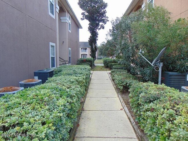
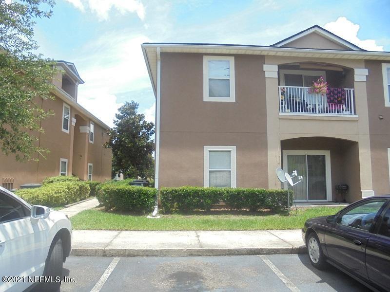
9690 Amarante Cir Unit 15
Jacksonville, FL 32257
2 Weeks Ago
Favorites
9690 Amarante Cir Unit 15

Favorites
Check Back Soon for Upcoming Availability
| Beds | Baths | Average SF |
|---|---|---|
| 3 Bedrooms 3 Bedrooms 3 Br | 2 Baths 2 Baths 2 Ba | 1,157 SF |
About This Property
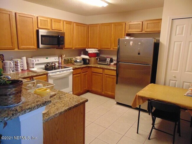
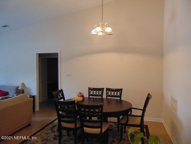
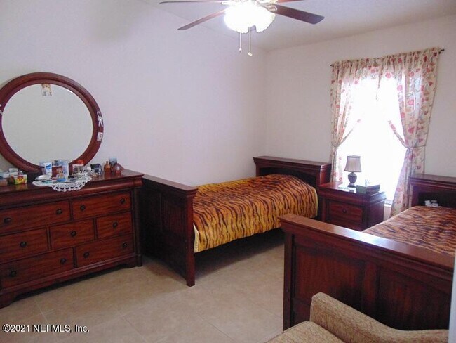
Beautiful completely tiled 2nd floor 3/2. Nice split floorplan with lots of kitchen cabinet space. Master bedroom has nice walk in closet and other two bedrooms on other side of condo with nice sized bathroom in between other bedrooms. Gated community close to shopping, schools, restaurants and schools.
9690 Amarante Cir is a condo located in Duval County and the 32257 ZIP Code. This area is served by the Duval County Public Schools attendance zone.
Location
Get Directions
Nestled alongside the Saint Johns River, the Southside is a sprawling community just south of Downtown Jacksonville. The Southside is largely residential, offering a wide variety of apartments, condos, townhomes, and houses available for rent in a peaceful locale.
In addition to its many residences, the Southside contains excellent shopping options at expansive retail destinations the Saint Johns Town Center and the Avenues. The Southside is also home to an array of family-fun venues, including Bravoz Entertainment Center, Autobahn Indoor Speedway, and Flight Fit N Fun Jacksonville, as well as outdoor recreation centers like Losco Regional Park, Mandarin Park, and numerous area golf courses.
Additional options for recreation abound on the river and beautiful neighboring beaches such as Neptune Beach, Jacksonville Beach, and Ponte Vedra Beach.
Learn more about living in Southside
Education
| Colleges & Universities | Distance | ||
|---|---|---|---|
| Colleges & Universities | Distance | ||
| Drive: | 9 min | 3.8 mi | |
| Drive: | 22 min | 11.6 mi | |
| Drive: | 23 min | 13.6 mi | |
| Drive: | 29 min | 14.1 mi |
9690 Amarante Cir Unit 15 is within 9 minutes or 3.8 miles from Florida Coastal School of Law. It is also near University of North Florida and Fla. State Coll. Jacksonville.
Schools


Public Elementary School
Grades PK-5
767 Students
Attendance Zone
Public Middle School
Grades 6-8
641 Students
Attendance Zone
Public High School
Grades 9-12
2,537 Students
Attendance Zone
Private Elementary, Middle & High School
Grades 4-12
81 Students
Nearby
Private Elementary & Middle School
Grades PK-8
212 Students
Nearby
Private Elementary & Middle School
Grades PK-8
94 Students
Nearby
School data provided by
 The GreatSchools Rating helps parents compare schools within a state based on a variety of school quality indicators and provides a helpful picture of how effectively each school serves all of its students. Ratings are on a scale of 1 (below average) to 10 (above average) and can include test scores, college readiness, academic progress, advanced courses, equity, discipline and attendance data. We also advise parents to visit schools, consider other information on school performance and programs, and consider family needs as part of the school selection process.
View GreatSchools Rating Methodology
Data provided by GreatSchools.org © 2025. All rights reserved.
View GreatSchools Rating Methodology
Data provided by GreatSchools.org © 2025. All rights reserved.
Transportation options available in Jacksonville include Kings Ave Station, located 11.5 miles from 9690 Amarante Cir Unit 15. 9690 Amarante Cir Unit 15 is near Jacksonville International, located 27.5 miles or 42 minutes away.
| Transit / Subway | Distance | ||
|---|---|---|---|
| Transit / Subway | Distance | ||
| Drive: | 19 min | 11.5 mi | |
|
|
Drive: | 19 min | 11.6 mi |
|
|
Drive: | 18 min | 11.9 mi |
|
|
Drive: | 19 min | 12.0 mi |
|
|
Drive: | 20 min | 12.7 mi |
| Commuter Rail | Distance | ||
|---|---|---|---|
| Commuter Rail | Distance | ||
|
|
Drive: | 31 min | 18.9 mi |
| Airports | Distance | ||
|---|---|---|---|
| Airports | Distance | ||
|
Jacksonville International
|
Drive: | 42 min | 27.5 mi |
Time and distance from 9690 Amarante Cir Unit 15.
| Shopping Centers | Distance | ||
|---|---|---|---|
| Shopping Centers | Distance | ||
| Walk: | 4 min | 0.3 mi | |
| Drive: | 3 min | 1.3 mi | |
| Drive: | 4 min | 1.5 mi |
9690 Amarante Cir Unit 15 has 3 shopping centers within 1.5 miles, which is about a 4-minute walk. The miles and minutes will be for the farthest away property.
| Parks and Recreation | Distance | ||
|---|---|---|---|
| Parks and Recreation | Distance | ||
|
Camp Tomahawk
|
Drive: | 7 min | 2.5 mi |
|
Walter Jones Historical Park
|
Drive: | 10 min | 4.9 mi |
|
Mandarin Park
|
Drive: | 15 min | 6.6 mi |
|
Touchton Road Park
|
Drive: | 15 min | 7.9 mi |
|
Lovelace Park
|
Drive: | 15 min | 8.1 mi |
9690 Amarante Cir Unit 15 has 5 parks within 8.1 miles, including Camp Tomahawk, Walter Jones Historical Park, and Mandarin Park.
| Hospitals | Distance | ||
|---|---|---|---|
| Hospitals | Distance | ||
| Drive: | 11 min | 5.2 mi | |
| Drive: | 13 min | 6.1 mi | |
| Drive: | 21 min | 11.2 mi |
9690 Amarante Cir Unit 15 has 3 hospitals within 11.2 miles, the nearest is Ascension St. Vincent's Southside which is 5.2 miles away and a 11 minute drive.
| Military Bases | Distance | ||
|---|---|---|---|
| Military Bases | Distance | ||
| Drive: | 20 min | 11.1 mi | |
| Drive: | 41 min | 24.4 mi |
9690 Amarante Cir Unit 15 is 11.1 miles from Jacksonville Naval Air Station, and is convenient to other military bases, including Mayport Naval Air Station.
You May Also Like
Similar Rentals Nearby
-
-
 $2,0003 Beds, 2 Baths, 1,408 sq ftCondo for Rent
 -
 $1,8453 Beds, 2 Baths, 1,408 sq ftCondo for Rent
 -
 $2,2953 Beds, 2 Baths, 1,492 sq ftCondo for Rent
 -
 $1,7003 Beds, 1 Bath, 1,549 sq ftApartment for Rent
 -
 $9993 Beds, 1 Bath, 800 sq ftApartment for Rent
 -

-
 $4,2003 Beds, 2 Baths, 1,388 sq ftCondo for Rent
 -
 $1,9953 Beds, 2 Baths, 1,700 sq ftCondo for Rent
 -

What Are Walk Score®, Transit Score®, and Bike Score® Ratings?
Walk Score® measures the walkability of any address. Transit Score® measures access to public transit. Bike Score® measures the bikeability of any address.
What is a Sound Score Rating?
A Sound Score Rating aggregates noise caused by vehicle traffic, airplane traffic and local sources
9690 Amarante Cir
Jacksonville, FL 32257