
$2,700
Total Monthly Price
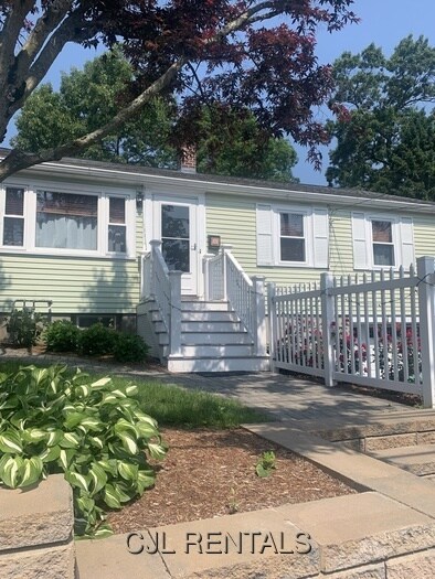
96 Prentice St Unit 96
Waltham, MA 02451
2 Weeks Ago
|
Edit
Favorites
96 Prentice St Unit 96

Favorites
Check Back Soon for Upcoming Availability
| Beds | Baths | Average SF |
|---|---|---|
| 3 Bedrooms 3 Bedrooms 3 Br | 2 Baths 2 Baths 2 Ba | — |
About This Property
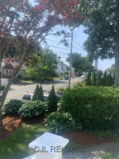
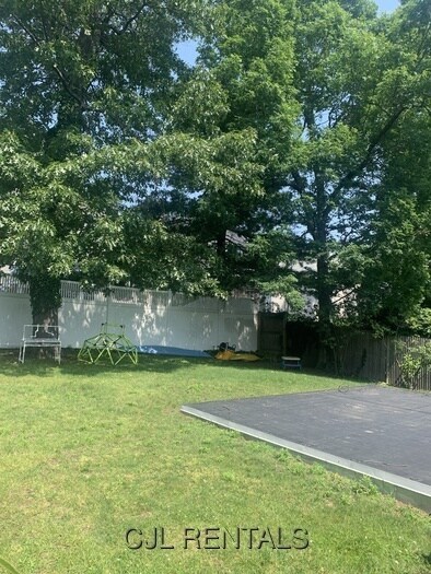
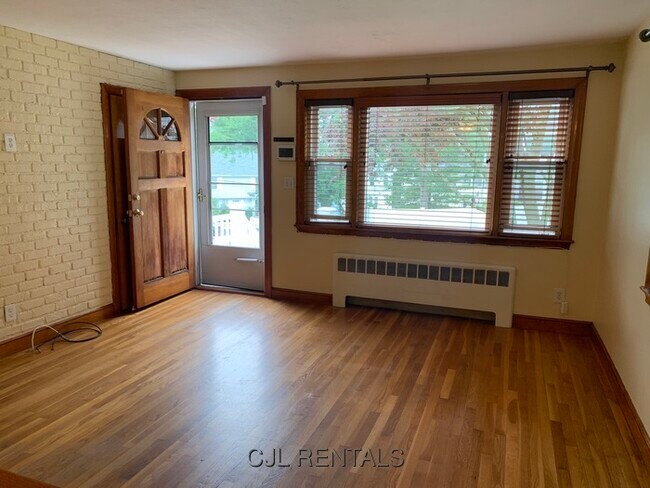
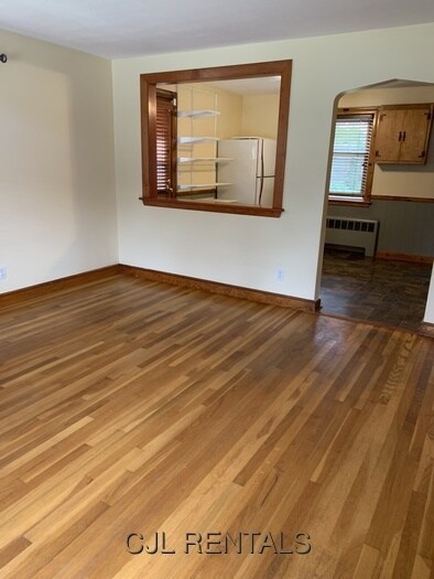
Cheerful, affordable, 3 bedroom, 2 full bath, ranch-style, single family house with 1 car garage! Convenient location, close to major routes, Brandeis and Bentley Universities and shopping! Hardwood floors, dishwasher/disposal, washer/dryer in basement . Full basement offers plenty of storage. Large fenced-in rear yard. Professionally manicured lot. Driveway parking for 2 cars plus 1 car garage under. Small dog or cat accepted. Utilities not included. Gas heat. Professionally manicured lot. (Landscaping included). Available immediately or August 1st. For in-person showing, email: .
96 Prentice St is a condo located in Middlesex County and the 02451 ZIP Code. This area is served by the Waltham School District attendance zone.
96 Prentice St,
Waltham,
MA
02451
Located 11 miles west of Boston along the Charles River, Waltham combines metropolitan accessibility with tree-lined neighborhoods. The city earned its "Watch City" nickname through its historic watchmaking industry and now houses both Brandeis and Bentley Universities. The rental market remains competitive, with average rents ranging from $2,002 for studios to $3,843 for three-bedroom units. Housing options span from riverside apartment communities to historic homes in established neighborhoods like Piety Corner and the Highlands.
Moody Street, known locally as "Restaurant Row," serves as the city's downtown hub, featuring an international array of restaurants and independent shops. The Charles River Museum of Industry & Innovation chronicles the area's manufacturing legacy, while the riverside paths offer miles of walking and cycling routes. Residents enjoy access to several parks and green spaces, including the preserved Gore Place estate and the scenic Prospect Hill Park.
Learn more about living in WalthamBelow are rent ranges for similar nearby apartments
Education
| Colleges & Universities | Distance | ||
|---|---|---|---|
| Colleges & Universities | Distance | ||
| Drive: | 5 min | 1.8 mi | |
| Drive: | 6 min | 2.4 mi | |
| Drive: | 16 min | 6.7 mi | |
| Drive: | 15 min | 7.1 mi |
96 Prentice St Unit 96 is within 5 minutes or 1.8 miles from Brandeis University. It is also near Bentley University and Boston College.
Schools


Public Elementary School
Grades PK-5
396 Students
Nearby
Public Elementary School
Grades K-5
335 Students
Attendance Zone
Public Middle School
Grades 6-8
645 Students
Attendance Zone
Public High School
Grades 9-12
1,784 Students
Attendance Zone
Private Elementary & Middle School
Grades PK-8
517 Students
Nearby
Private Elementary & Middle School
Grades PK-8
115 Students
Nearby
Private Elementary, Middle & High School
Grades K-12
80 Students
Nearby
Private Middle & High School
Grades 6-12
178 Students
Nearby
School data provided by
 The GreatSchools Rating helps parents compare schools within a state based on a variety of school quality indicators and provides a helpful picture of how effectively each school serves all of its students. Ratings are on a scale of 1 (below average) to 10 (above average) and can include test scores, college readiness, academic progress, advanced courses, equity, discipline and attendance data. We also advise parents to visit schools, consider other information on school performance and programs, and consider family needs as part of the school selection process.
View GreatSchools Rating Methodology
Data provided by GreatSchools.org © 2026. All rights reserved.
View GreatSchools Rating Methodology
Data provided by GreatSchools.org © 2026. All rights reserved.
Transportation options available in Waltham include Riverside Station, located 3.8 miles from 96 Prentice St Unit 96. 96 Prentice St Unit 96 is near General Edward Lawrence Logan International, located 15.1 miles or 27 minutes away, and Worcester Regional, located 40.6 miles or 58 minutes away.
| Transit / Subway | Distance | ||
|---|---|---|---|
| Transit / Subway | Distance | ||
|
|
Drive: | 9 min | 3.8 mi |
|
|
Drive: | 9 min | 4.4 mi |
|
|
Drive: | 13 min | 6.0 mi |
|
|
Drive: | 11 min | 6.2 mi |
|
|
Drive: | 13 min | 7.8 mi |
| Commuter Rail | Distance | ||
|---|---|---|---|
| Commuter Rail | Distance | ||
|
|
Drive: | 3 min | 1.3 mi |
| Drive: | 3 min | 1.3 mi | |
|
|
Drive: | 4 min | 1.7 mi |
|
|
Drive: | 4 min | 2.0 mi |
|
|
Drive: | 14 min | 7.9 mi |
| Airports | Distance | ||
|---|---|---|---|
| Airports | Distance | ||
|
General Edward Lawrence Logan International
|
Drive: | 27 min | 15.1 mi |
|
Worcester Regional
|
Drive: | 58 min | 40.6 mi |
Walkability Near 96 Prentice St Waltham, MA 02451
Getting Around
 What do Walkability, Transit, Drivability, and Bikeability mean?
Walkability measures the walking distance to day-to-day needs.
Transit measures access to public transportation.
Drivability measures congestion, parking availability, and access to major roads.
Bikeability measures the suitability for cycling.
How It Works
What do Walkability, Transit, Drivability, and Bikeability mean?
Walkability measures the walking distance to day-to-day needs.
Transit measures access to public transportation.
Drivability measures congestion, parking availability, and access to major roads.
Bikeability measures the suitability for cycling.
How It Works
Moderately Walkable
Walkability
60
/ 100
Limited Public Transit
Transit
30
/ 100
Exceptionally Drivable
Drivability
90
/ 100
Moderately Bikeable
Bikeability
60
/ 100
Scores provided by
-
Soundscore™
-
/ 100
Traffic
-Airport
-Businesses
-Scores provided by
HowLoud What is a Sound Score Rating? A Sound Score Rating aggregates noise caused by vehicle traffic, airplane traffic and local sources. How It WorksTime and distance from 96 Prentice St Unit 96.
| Shopping Centers | Distance | ||
|---|---|---|---|
| Shopping Centers | Distance | ||
| Walk: | 9 min | 0.5 mi | |
| Walk: | 15 min | 0.8 mi | |
| Drive: | 4 min | 1.4 mi |
96 Prentice St Unit 96 has 3 shopping centers within 1.4 miles, which is about a 4-minute drive. The miles and minutes will be for the farthest away property.
| Parks and Recreation | Distance | ||
|---|---|---|---|
| Parks and Recreation | Distance | ||
|
Land's Sake Farm
|
Drive: | 7 min | 3.3 mi |
|
Beaver Brook Reservation
|
Drive: | 6 min | 3.4 mi |
|
Mass Audubon's Habitat Education Center and Wildlife Sanctuary
|
Drive: | 11 min | 5.2 mi |
|
Mass Audubon's Drumlin Farm Wildlife Sanctuary
|
Drive: | 10 min | 5.6 mi |
|
Codman Community Farms
|
Drive: | 10 min | 5.7 mi |
96 Prentice St Unit 96 has 5 parks within 5.7 miles, including Beaver Brook Reservation, Land's Sake Farm, and Mass Audubon's Habitat Education Center and Wildlife Sanctuary.
| Hospitals | Distance | ||
|---|---|---|---|
| Hospitals | Distance | ||
| Walk: | 19 min | 1.0 mi | |
| Drive: | 7 min | 3.8 mi | |
| Drive: | 9 min | 5.3 mi |
96 Prentice St Unit 96 has 3 hospitals within 5.3 miles, the nearest is Walden Behavioral Care which is 1.0 miles away and a 19 minute walk.
| Military Bases | Distance | ||
|---|---|---|---|
| Military Bases | Distance | ||
| Drive: | 16 min | 7.5 mi | |
| Drive: | 20 min | 11.1 mi |
96 Prentice St Unit 96 is 7.5 miles from Hanscom Air Force Base, and is convenient to other military bases, including US Military Reservation.
You May Also Like
Similar Rentals Nearby


What Are Walk Score®, Transit Score®, and Bike Score® Ratings?
Walk Score® measures the walkability of any address. Transit Score® measures access to public transit. Bike Score® measures the bikeability of any address.
What is a Sound Score Rating?
A Sound Score Rating aggregates noise caused by vehicle traffic, airplane traffic and local sources.

96 Prentice St
Waltham, MA 02451