$1,590
/ Month
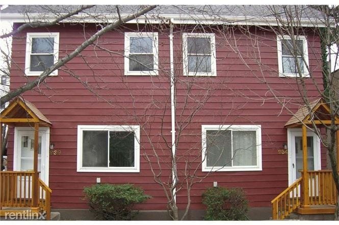
936 Saint James St
Shadyside, PA 15232
2 Weeks Ago
|
Edit
Favorites
936 Saint James St

Favorites
Check Back Soon for Upcoming Availability
| Beds | Baths | Average SF |
|---|---|---|
| 2 Bedrooms 2 Bedrooms 2 Br | 2 Baths 2 Baths 2 Ba | — |
About This Property
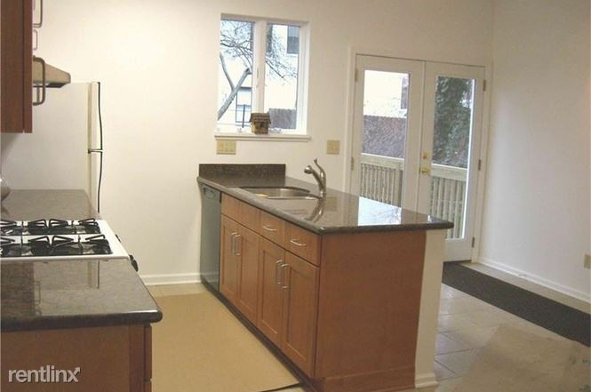
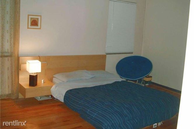
(412) 580-3310 - Prime location, 2BR + 2BA duplex on St James street. Walk to Walnut, CMU, restaurants, grocery store... Kitchen with island, granite countertops, deck, back yard, washer/dryer, central air, on street parking. (RLNE2628136) Other Amenities - Basement, Yard, Patio, Deck. Appliances - Dishwasher, Air Conditioning, Refrigerator, Range, Oven, Garbage Disposal, Washer & Dryer, Microwave. Lease lengths - Month to Month, 6 Months, 12 Months, 24 Months. Details regarding this property's Utilities - Trash Pick-up Included.
936 Saint James St is a townhome located in Allegheny County and the 15232 ZIP Code. This area is served by the Pittsburgh Public Schools attendance zone.
Townhome Features
- Air Conditioning
936 Saint James St,
Shadyside,
PA
15232
Situated in Pittsburgh’s East End, Shadyside offers a bit of everything. Restored Victorian mansions and luxury apartments sit along tree-lined streets in addition to national retailers and locally-owned boutiques. Shadyside contains three business districts, all located within walking distance of one another – Walnut Street, Ellsworth Avenue, and South Highland Avenue. The Annual Art Festival on Walnut Street is regarded as one of the top art shows in Pennsylvania, displaying handmade artwork crafted by over 140 artists every summer.
Shadyside residents enjoy nearby access to a host of local amenities, including outdoor venues like Mellon Park, the Monongahela River, Frick Park, Schenley Park, and the Pittsburgh Zoo and Aquarium. The neighborhood is also proximate to cultural institutions like the Pittsburgh Center for the Arts, Carnegie Mellon University, University of Pittsburgh, Chatham University, and West Penn Hospital.
Learn more about living in ShadysideBelow are rent ranges for similar nearby apartments
Amenities
- Air Conditioning
Education
| Colleges & Universities | Distance | ||
|---|---|---|---|
| Colleges & Universities | Distance | ||
| Walk: | 14 min | 0.7 mi | |
| Walk: | 18 min | 0.9 mi | |
| Drive: | 4 min | 1.5 mi | |
| Drive: | 5 min | 1.9 mi |
936 Saint James St is within 14 minutes or 0.7 mile from Carnegie Mellon University. It is also near Chatham University and University of Pittsburgh.
Schools


Public Elementary School
Grades PK-5
324 Students
Nearby
Public Elementary & Middle School
Grades K-8
732 Students
Attendance Zone
Private Elementary, Middle & High School
Grades PK-12
715 Students
Nearby
Private High School
Grades 9-12
36 Students
Nearby
School data provided by
 The GreatSchools Rating helps parents compare schools within a state based on a variety of school quality indicators and provides a helpful picture of how effectively each school serves all of its students. Ratings are on a scale of 1 (below average) to 10 (above average) and can include test scores, college readiness, academic progress, advanced courses, equity, discipline and attendance data. We also advise parents to visit schools, consider other information on school performance and programs, and consider family needs as part of the school selection process.
View GreatSchools Rating Methodology
Data provided by GreatSchools.org © 2026. All rights reserved.
View GreatSchools Rating Methodology
Data provided by GreatSchools.org © 2026. All rights reserved.
Transportation options available in Shadyside include First Avenue, located 3.7 miles from 936 Saint James St. 936 Saint James St is near Pittsburgh International, located 20.9 miles or 33 minutes away, and Arnold Palmer Regional, located 40.0 miles or 67 minutes away.
| Transit / Subway | Distance | ||
|---|---|---|---|
| Transit / Subway | Distance | ||
|
|
Drive: | 8 min | 3.7 mi |
|
|
Drive: | 8 min | 3.8 mi |
|
|
Drive: | 8 min | 4.0 mi |
|
|
Drive: | 9 min | 4.1 mi |
|
|
Drive: | 9 min | 4.4 mi |
| Commuter Rail | Distance | ||
|---|---|---|---|
| Commuter Rail | Distance | ||
|
|
Drive: | 9 min | 4.1 mi |
|
|
Drive: | 50 min | 30.6 mi |
|
|
Drive: | 63 min | 37.0 mi |
|
|
Drive: | 65 min | 46.7 mi |
| Airports | Distance | ||
|---|---|---|---|
| Airports | Distance | ||
|
Pittsburgh International
|
Drive: | 33 min | 20.9 mi |
|
Arnold Palmer Regional
|
Drive: | 67 min | 40.0 mi |
Walkability Near 936 Saint James St Shadyside, PA 15232
Getting Around
 What do Walkability, Transit, Drivability, and Bikeability mean?
Walkability measures the walking distance to day-to-day needs.
Transit measures access to public transportation.
Drivability measures congestion, parking availability, and access to major roads.
Bikeability measures the suitability for cycling.
How It Works
What do Walkability, Transit, Drivability, and Bikeability mean?
Walkability measures the walking distance to day-to-day needs.
Transit measures access to public transportation.
Drivability measures congestion, parking availability, and access to major roads.
Bikeability measures the suitability for cycling.
How It Works
Exceptionally Walkable
Walkability
90
/ 100
Good Public Transit
Transit
70
/ 100
Fairly Drivable
Drivability
50
/ 100
Moderately Bikeable
Bikeability
60
/ 100
Scores provided by
-
Soundscore™
-
/ 100
Traffic
-Airport
-Businesses
-Scores provided by
HowLoud What is a Sound Score Rating? A Sound Score Rating aggregates noise caused by vehicle traffic, airplane traffic and local sources. How It WorksTime and distance from 936 Saint James St.
| Shopping Centers | Distance | ||
|---|---|---|---|
| Shopping Centers | Distance | ||
| Walk: | 20 min | 1.1 mi | |
| Drive: | 3 min | 1.2 mi | |
| Drive: | 4 min | 1.3 mi |
936 Saint James St has 3 shopping centers within 1.3 miles, which is about a 4-minute drive. The miles and minutes will be for the farthest away property.
| Parks and Recreation | Distance | ||
|---|---|---|---|
| Parks and Recreation | Distance | ||
|
Chatham Arboretum
|
Walk: | 18 min | 0.9 mi |
|
Carnegie Museum of Natural History
|
Drive: | 3 min | 1.1 mi |
|
Schenley Park
|
Drive: | 5 min | 1.7 mi |
|
Phipps Conservatory and Gardens
|
Drive: | 5 min | 1.8 mi |
|
Frick Environmental Center
|
Drive: | 7 min | 2.3 mi |
936 Saint James St has 5 parks within 2.3 miles, including Chatham Arboretum, Carnegie Museum of Natural History, and Schenley Park.
| Hospitals | Distance | ||
|---|---|---|---|
| Hospitals | Distance | ||
| Drive: | 4 min | 1.3 mi | |
| Drive: | 4 min | 1.6 mi | |
| Drive: | 4 min | 1.7 mi |
936 Saint James St has 3 hospitals within 1.7 miles, the nearest is West Penn Hospital which is 1.3 miles away and a 4 minute drive.
| Military Bases | Distance | ||
|---|---|---|---|
| Military Bases | Distance | ||
| Drive: | 29 min | 19.4 mi |
936 Saint James St is 19.4 miles and a 29 minute drive from Pittsburgh Air Reserve Station.
You May Also Like
Similar Rentals Nearby


What Are Walk Score®, Transit Score®, and Bike Score® Ratings?
Walk Score® measures the walkability of any address. Transit Score® measures access to public transit. Bike Score® measures the bikeability of any address.
What is a Sound Score Rating?
A Sound Score Rating aggregates noise caused by vehicle traffic, airplane traffic and local sources.

936 Saint James St
Shadyside, PA 15232