
$1,850
/ Month
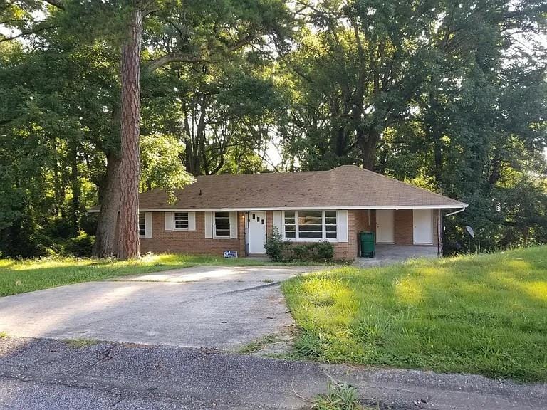
923 Laurel St
Morrow, GA 30260
Today
|
Edit
Favorites
678-886-2280
-
Bedrooms
3
-
Bathrooms
1.5
-
Square Feet
1,873 sq ft
-
Available
Available Now
Highlights
- City View
- Ranch Style House
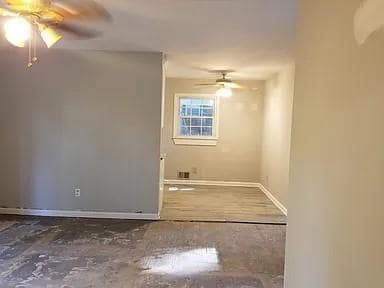
- Wood Flooring
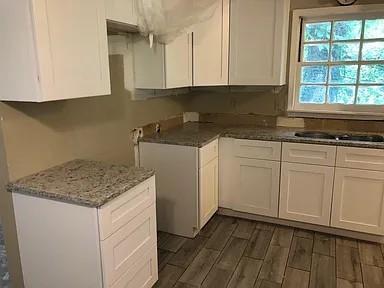
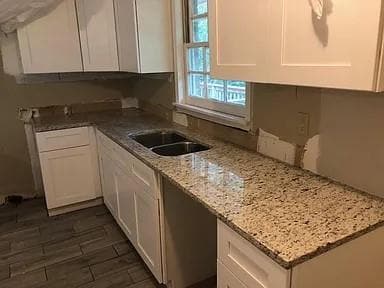
- Solid Surface Countertops
- Den
- White Kitchen Cabinets
923 Laurel St

Favorites
About This Home
Available Now
Very quiet neighborhood. Hardwood Floors.
923 Laurel St is a house located in Clayton County and the 30260 ZIP Code. This area is served by the Clayton County attendance zone.
* Price shown is base rent. Excludes user-selected optional fees and variable or usage-based fees and required charges due at or prior to move-in or at move-out. Price, availability, fees, and any applicable rent special are subject to change without notice.
* Square footage definitions vary. Displayed square footage is approximate.
Home Details
Home Type
Single Family Detached Home
Year Built
Built in 1965
Basement
Crawl Space
Bedrooms and Bathrooms
3 Main Level Bedrooms
1.5 Bathrooms
Home Design
Ranch Style House
Four Sided Brick Exterior Elevation
Composition Roof
Interior Spaces
Wood Flooring
Den
1,873 Sq Ft Home
Kitchen
Solid Surface Countertops
White Kitchen Cabinets
Electric Range
Laundry
Laundry Room
Laundry on main level
Listing and Financial Details
Security Deposit $1,950
12 Month Lease Term
Assessor Parcel Number 13080C C015
Location
Property is near schools
Property is near shops
Lot Details
0.75 Acre Lot
No Common Walls
Sloped Lot
Parking
2 Carport Spaces
Parking Pad
Schools
Lake City Elementary School
Babb Middle School
Forest Park High School
Utilities
Forced Air Heating and Cooling System
Cable TV Available
Views
City
Neighborhood
Community Details
Overview
West Woodland Heights Subdivision
Pet Policy
Call for details about the types of pets allowed
Contact
- Listed by MICHAEL MILLER | Nelson Rives Realty,Inc.
- Phone Number
- Contact
-
Source
 First Multiple Listing Service, Inc.
Copyright © 2025 First Multiple Listing Service, Inc. All rights reserved. All information provided by the listing agent/broker is deemed reliable but is not guaranteed and should be independently verified.
Location
Get Directions
Amenities
- Range
Morrow, Georgia is a convenient suburb for commuters, with a short travel distance of only 15 miles to Atlanta. Morrow houses part of the Reynolds Nature Preserve and Big Pond. Take advantage of the wildlife viewing opportunities on the rolling hills, forests, and wetlands. Morrow also surrounds the north end of Lake Louise.
Clayton State University lies on the eastern border of town and is a great place for educational growth. On the south end of town, you’ll want to visit Southlake Mall for all of the major department stores. Morrow has very affordable apartments with great amenities all over the city. After you find your apartment, visit VN Pho on Jonesboro Road for the best Vietnamese noodle soups and bubble tea in Morrow.
Learn more about living in Morrow
Education
| Colleges & Universities | Distance | ||
|---|---|---|---|
| Colleges & Universities | Distance | ||
| Drive: | 6 min | 2.6 mi | |
| Drive: | 18 min | 9.4 mi | |
| Drive: | 22 min | 10.1 mi | |
| Drive: | 20 min | 11.8 mi |
923 Laurel St is within 6 minutes or 2.6 miles from Clayton State University. It is also near Atlanta Metropolitan State and Atlanta Technical College.
Schools


Public Elementary School
Grades PK-5
509 Students
Attendance Zone
Public Middle School
Grades 6-8
888 Students
Attendance Zone
Public High School
Grades 9-12
1,765 Students
Attendance Zone
Private Elementary School
Grades PK-5
30 Students
Nearby
Private Elementary & Middle School
Grades K-8
Nearby
Private Elementary, Middle & High School
Grades K-12
Nearby
School data provided by
 The GreatSchools Rating helps parents compare schools within a state based on a variety of school quality indicators and provides a helpful picture of how effectively each school serves all of its students. Ratings are on a scale of 1 (below average) to 10 (above average) and can include test scores, college readiness, academic progress, advanced courses, equity, discipline and attendance data. We also advise parents to visit schools, consider other information on school performance and programs, and consider family needs as part of the school selection process.
View GreatSchools Rating Methodology
Data provided by GreatSchools.org © 2025. All rights reserved.
View GreatSchools Rating Methodology
Data provided by GreatSchools.org © 2025. All rights reserved.
Transportation options available in Morrow include East Point, located 8.6 miles from 923 Laurel St. 923 Laurel St is near Hartsfield - Jackson Atlanta International, located 6.1 miles or 14 minutes away.
| Transit / Subway | Distance | ||
|---|---|---|---|
| Transit / Subway | Distance | ||
|
|
Drive: | 19 min | 8.6 mi |
|
|
Drive: | 19 min | 8.9 mi |
|
|
Drive: | 19 min | 9.3 mi |
|
|
Drive: | 19 min | 10.3 mi |
|
|
Drive: | 19 min | 11.1 mi |
| Commuter Rail | Distance | ||
|---|---|---|---|
| Commuter Rail | Distance | ||
|
|
Drive: | 27 min | 16.2 mi |
| Airports | Distance | ||
|---|---|---|---|
| Airports | Distance | ||
|
Hartsfield - Jackson Atlanta International
|
Drive: | 14 min | 6.1 mi |
Time and distance from 923 Laurel St.
| Shopping Centers | Distance | ||
|---|---|---|---|
| Shopping Centers | Distance | ||
| Walk: | 20 min | 1.0 mi | |
| Walk: | 20 min | 1.1 mi | |
| Drive: | 3 min | 1.1 mi |
923 Laurel St has 3 shopping centers within 1.1 miles, which is about a 3-minute drive. The miles and minutes will be for the farthest away property.
| Parks and Recreation | Distance | ||
|---|---|---|---|
| Parks and Recreation | Distance | ||
|
Zoo Atlanta
|
Drive: | 22 min | 10.9 mi |
|
Ferns of the World Garden
|
Drive: | 19 min | 11.5 mi |
|
Trees Atlanta
|
Drive: | 23 min | 11.6 mi |
|
The Georgia Capitol Museum
|
Drive: | 20 min | 11.9 mi |
|
West Atlanta Watershed Alliance (WAWA)
|
Drive: | 24 min | 13.3 mi |
923 Laurel St has 5 parks within 13.3 miles, including Ferns of the World Garden, Zoo Atlanta, and The Georgia Capitol Museum.
| Hospitals | Distance | ||
|---|---|---|---|
| Hospitals | Distance | ||
| Drive: | 8 min | 3.6 mi | |
| Drive: | 9 min | 3.7 mi | |
| Drive: | 12 min | 6.4 mi |
923 Laurel St has 3 hospitals within 6.4 miles, the nearest is Southern Regional Medical Center which is 3.6 miles away and a 8 minute drive.
| Military Bases | Distance | ||
|---|---|---|---|
| Military Bases | Distance | ||
| Drive: | 10 min | 3.6 mi | |
| Drive: | 20 min | 10.6 mi |
923 Laurel St is 3.6 miles from Fort Gillem, and is convenient to other military bases, including Fort McPherson.
You May Also Like
Similar Rentals Nearby
-
-
-
1 / 58

-
-
-
-
-
-
-


What Are Walk Score®, Transit Score®, and Bike Score® Ratings?
Walk Score® measures the walkability of any address. Transit Score® measures access to public transit. Bike Score® measures the bikeability of any address.
What is a Sound Score Rating?
A Sound Score Rating aggregates noise caused by vehicle traffic, airplane traffic and local sources

923 Laurel St
Morrow, GA 30260