
Venue Residences
3688 Overland Ave,
Los Angeles, CA 90034
$3,550 - $4,795
1-2 Beds

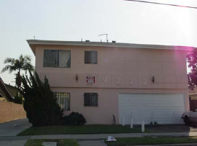
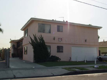

Find your new apartment at 9222 S Budlong Ave. This property is situated in the Westmont area of Los Angeles. Compare 1 to 2 bedroom apartments. The leasing staff is excited to help you find your ideal place. Stop by the leasing office to schedule your tour.
9222 S Budlong Ave is an apartment community located in Los Angeles County and the 90044 ZIP Code. This area is served by the Los Angeles Unified Rocp School District attendance zone.
Westmont is a community east of Inglewood in the southern part of Los Angeles. Westmont is characterized as a typical Los Angeles neighborhood with well-populated residential avenues holding an array of rental choices. Shops and restaurants dot the neighborhood, but large shopping centers like Crenshaw Imperial Plaza and the Village at Century are located within minutes of Westmont. Despite being in the urbanized Los Angeles region, outdoor adventure abounds in nearby golf courses, parks, and recreation centers. Commuters appreciate the neighborhood’s easy access to Interstate 105 and 110 junction, making travel in and around the are simple and convenient.
Learn more about living in WestmontCompare neighborhood and city base rent averages by bedroom.
| Westmont | Los Angeles, CA | |
|---|---|---|
| Studio | $871 | $1,710 |
| 1 Bedroom | $1,522 | $2,178 |
| 2 Bedrooms | $1,713 | $3,017 |
| 3 Bedrooms | $2,392 | $4,259 |
| Colleges & Universities | Distance | ||
|---|---|---|---|
| Colleges & Universities | Distance | ||
| Drive: | 6 min | 2.6 mi | |
| Drive: | 11 min | 6.0 mi | |
| Drive: | 12 min | 6.6 mi | |
| Drive: | 12 min | 7.3 mi |


Transportation options available in Los Angeles include Vermont Station, located 1.9 miles from 9222 S Budlong Ave. 9222 S Budlong Ave is near Los Angeles International, located 7.1 miles or 14 minutes away, and Long Beach (Daugherty Field), located 15.8 miles or 24 minutes away.
| Transit / Subway | Distance | ||
|---|---|---|---|
| Transit / Subway | Distance | ||
|
|
Drive: | 3 min | 1.9 mi |
|
|
Drive: | 4 min | 2.5 mi |
|
|
Drive: | 6 min | 3.5 mi |
| Drive: | 8 min | 4.0 mi | |
|
|
Drive: | 7 min | 4.4 mi |
| Commuter Rail | Distance | ||
|---|---|---|---|
| Commuter Rail | Distance | ||
|
|
Drive: | 15 min | 10.5 mi |
|
|
Drive: | 17 min | 10.7 mi |
|
|
Drive: | 22 min | 12.7 mi |
|
|
Drive: | 24 min | 14.2 mi |
| Drive: | 19 min | 14.5 mi |
| Airports | Distance | ||
|---|---|---|---|
| Airports | Distance | ||
|
Los Angeles International
|
Drive: | 14 min | 7.1 mi |
|
Long Beach (Daugherty Field)
|
Drive: | 24 min | 15.8 mi |
Scores provided by
Traffic
-Airport
-Businesses
-Scores provided by
HowLoud What is a Sound Score Rating? A Sound Score Rating aggregates noise caused by vehicle traffic, airplane traffic and local sources. How It WorksTime and distance from 9222 S Budlong Ave.
| Shopping Centers | Distance | ||
|---|---|---|---|
| Shopping Centers | Distance | ||
| Walk: | 14 min | 0.8 mi | |
| Drive: | 4 min | 1.4 mi | |
| Drive: | 3 min | 1.6 mi |
| Parks and Recreation | Distance | ||
|---|---|---|---|
| Parks and Recreation | Distance | ||
|
Watts Senior Center & Rose Garden
|
Drive: | 6 min | 3.6 mi |
|
Watts Towers-Rodia State Park
|
Drive: | 8 min | 4.2 mi |
|
Natural History Museum of LA County
|
Drive: | 10 min | 5.2 mi |
|
Augustus Hawkins Natural Park
|
Drive: | 9 min | 5.8 mi |
|
California Science Center
|
Drive: | 10 min | 6.0 mi |
| Hospitals | Distance | ||
|---|---|---|---|
| Hospitals | Distance | ||
| Drive: | 7 min | 3.7 mi | |
| Drive: | 7 min | 4.6 mi | |
| Drive: | 9 min | 4.9 mi |
| Military Bases | Distance | ||
|---|---|---|---|
| Military Bases | Distance | ||
| Drive: | 12 min | 8.3 mi |
Pets Allowed In Unit Washer & Dryer Maintenance on site Heat Controlled Access Elevator
What Are Walk Score®, Transit Score®, and Bike Score® Ratings?
Walk Score® measures the walkability of any address. Transit Score® measures access to public transit. Bike Score® measures the bikeability of any address.
What is a Sound Score Rating?
A Sound Score Rating aggregates noise caused by vehicle traffic, airplane traffic and local sources.
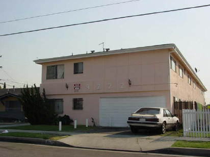
9222 S Budlong Ave
Los Angeles, CA 90044


