

$1,700
/ Month
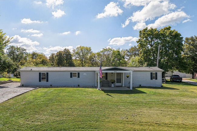
9166 Porter Rd
Ryland Heights, KY 41015
Today
|
Edit
Favorites
513-532-5662
-
Bedrooms
3
-
Bathrooms
2
-
Square Feet
980 sq ft
-
Available
Available Jan 23
Highlights
- View of Trees or Woods
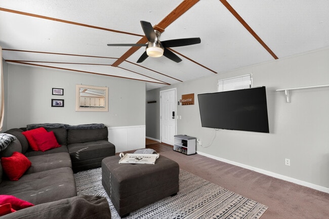
- Open Floorplan
- Deck
- Traditional Architecture
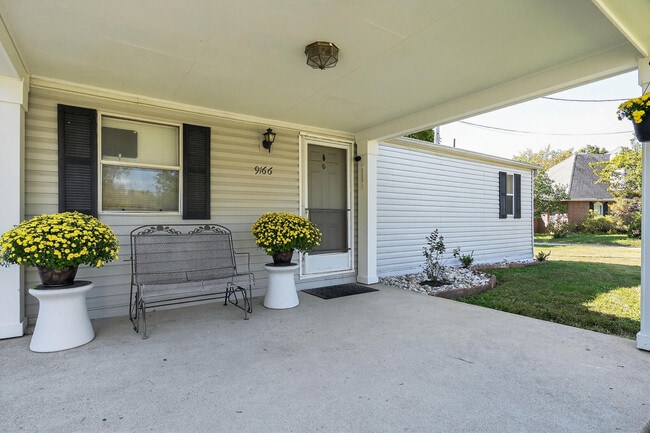
- Porch
- Eat-In Kitchen
9166 Porter Rd

Favorites
About This Home
Available Jan 23
Enjoy peaceful country living surrounded by beautiful Ky scenery! This home sits on on a deep 5.4-acre lot with room to roam. .The setting is rural yet super convenient to 275. The property features a large flat backyard,perfect for outdoor fun,plus a fire pit area,spacious deck,and a large shed ideal for a workshop or tinkering space. Inside,you'll find a remodeled kitchen with modern finishes & appliances and a remodeled primary suite bath featuring a double vanity and a large walk-in shower. Affordable,comfortable,and move-in ready—and plenty of space to enjoy a relaxed lifestyle surrounded by Kentucky countryside.
9166 Porter Rd is a house located in Kenton County and the 41015 ZIP Code. This area is served by the Kenton County attendance zone.
* Price shown is base rent. Excludes user-selected optional fees and variable or usage-based fees and required charges due at or prior to move-in or at move-out. Price, availability, fees, and any applicable rent special are subject to change without notice.
* Square footage definitions vary. Displayed square footage is approximate.
Home Details
Home Type
Single Family Detached Home
Year Built
Built in 1994
Bedrooms and Bathrooms
Double Vanity
Walk-In Closet
En-Suite Bathroom
Built-In Shower Bench
2 Full Bathrooms
3 Bedrooms
Home Design
Traditional Architecture
Shingle Roof
Aluminum Siding
Block Foundation
Interior Spaces
Open Floorplan
Built-In Features
Living Room
1-Story Property
Ceiling Fan
Carpet
980 Sq Ft Home
Vinyl Clad Windows
Kitchen
Electric Range
Eat-In Kitchen
Microwave
Dishwasher
Laundry
Laundry Room
Listing and Financial Details
Security Deposit $1,700
12 Month Lease Term
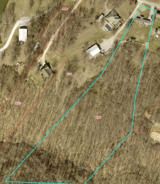
Assessor Parcel Number 071-00-00-076.01
No Smoking Allowed
Lot Details
1.38 Acre Lot
Split Rail Fence
Partially Fenced Property
Outdoor Features
Deck
Porch
Shed
Parking
Driveway
Schools
Ryland Heights Elementary School
Woodland Middle School
Scott High School
Utilities
Central Air
Heat Pump System
Cable TV Available
Septic Tank
Views
Views of Woods
Community Details
Overview
No Home Owners Association
Pet Policy
Pet Deposit $250
2 Pets Allowed
Contact
- Listed by Megan Hosea Abner | Ken Perry Realty
- Phone Number
- Contact
-
Source
Northern Kentucky Association of REALTORS®
Copyright © 2026 Northern Kentucky Association of REALTORS. All rights reserved. All information provided by the listing agent/broker is deemed reliable but is not guaranteed and should be independently verified.
Location
Get Directions
Amenities
- Air Conditioning
- Dishwasher
- Range
- Views
Northern Kentucky is a sprawling region located just south of Cincinnati, Ohio. The Ohio River hugs the northern, eastern, and western portions of the region, serving as a scenic destination for all kinds of outdoor recreation throughout the year. Florence, Dayton, Newport, Covington, Burlington, and Highland Heights are among the many communities included in the Northern Kentucky region.
Each community in Northern Kentucky offers its own unique identity and sense of character. The rentals in the area are just as diverse as Northern Kentucky itself, ranging from luxury apartments to charming houses and everything in between. Getting around the region is a breeze with convenience to Interstates 71, 75, 275, and 471.
Learn more about living in Northern Kentucky
Education
| Colleges & Universities | Distance | ||
|---|---|---|---|
| Colleges & Universities | Distance | ||
| Drive: | 18 min | 8.3 mi | |
| Drive: | 18 min | 8.8 mi | |
| Drive: | 27 min | 15.7 mi | |
| Drive: | 28 min | 15.8 mi |
9166 Porter Rd is within 18 minutes or 8.3 miles from Northern Kentucky University. It is also near Thomas More College and University of Cincinnati.
Schools


Public Elementary School
Grades PK-5
454 Students
Attendance Zone
Public Middle School
Grades 6-8
616 Students
Attendance Zone
Public High School
Grades 9-12
1,071 Students
Attendance Zone
Private Elementary, Middle & High School
Grades PK-12
383 Students
Nearby
School data provided by
 The GreatSchools Rating helps parents compare schools within a state based on a variety of school quality indicators and provides a helpful picture of how effectively each school serves all of its students. Ratings are on a scale of 1 (below average) to 10 (above average) and can include test scores, college readiness, academic progress, advanced courses, equity, discipline and attendance data. We also advise parents to visit schools, consider other information on school performance and programs, and consider family needs as part of the school selection process.
View GreatSchools Rating Methodology
Data provided by GreatSchools.org © 2026. All rights reserved.
View GreatSchools Rating Methodology
Data provided by GreatSchools.org © 2026. All rights reserved.
Transportation options available in Ryland Heights include The Banks Station, 2Nd & Main, located 11.6 miles from 9166 Porter Rd. 9166 Porter Rd is near Cincinnati/Northern Kentucky International, located 14.7 miles or 32 minutes away.
| Transit / Subway | Distance | ||
|---|---|---|---|
| Transit / Subway | Distance | ||
| Drive: | 23 min | 11.6 mi | |
| Drive: | 23 min | 11.7 mi | |
| Drive: | 23 min | 13.6 mi | |
| Drive: | 24 min | 13.8 mi | |
| Drive: | 23 min | 13.8 mi |
| Commuter Rail | Distance | ||
|---|---|---|---|
| Commuter Rail | Distance | ||
|
|
Drive: | 26 min | 12.7 mi |
| Airports | Distance | ||
|---|---|---|---|
| Airports | Distance | ||
|
Cincinnati/Northern Kentucky International
|
Drive: | 32 min | 14.7 mi |
Time and distance from 9166 Porter Rd.
| Shopping Centers | Distance | ||
|---|---|---|---|
| Shopping Centers | Distance | ||
| Drive: | 10 min | 3.9 mi | |
| Drive: | 12 min | 4.0 mi | |
| Drive: | 19 min | 9.4 mi |
9166 Porter Rd has 3 shopping centers within 9.4 miles, which is about a 19-minute drive. The miles and minutes will be for the farthest away property.
| Parks and Recreation | Distance | ||
|---|---|---|---|
| Parks and Recreation | Distance | ||
|
Newport Aquarium
|
Drive: | 24 min | 9.5 mi |
|
John G. & Phyllis W. Smale Riverfront Park
|
Drive: | 23 min | 11.7 mi |
|
California Woods Nature Preserve
|
Drive: | 22 min | 11.8 mi |
|
Theodore M. Berry Friendship Park
|
Drive: | 23 min | 13.9 mi |
|
Withrow Nature Preserve
|
Drive: | 24 min | 14.8 mi |
9166 Porter Rd has 5 parks within 14.8 miles, including Newport Aquarium, John G. & Phyllis W. Smale Riverfront Park, and Theodore M. Berry Friendship Park.
| Hospitals | Distance | ||
|---|---|---|---|
| Hospitals | Distance | ||
| Drive: | 20 min | 9.2 mi | |
| Drive: | 20 min | 11.0 mi | |
| Drive: | 25 min | 14.9 mi |
9166 Porter Rd has 3 hospitals within 14.9 miles, the nearest is St. Elizabeth Edgewood which is 9.2 miles away and a 20 minute drive.
| Military Bases | Distance | ||
|---|---|---|---|
| Military Bases | Distance | ||
| Drive: | 92 min | 66.2 mi | |
| Drive: | 98 min | 71.2 mi | |
| Drive: | 100 min | 74.5 mi |
9166 Porter Rd has 3 military bases within 74.5 miles, the nearest is Gentile Air Force Station which is 66.2 miles away and a 92 minute drive.
You May Also Like
Similar Rentals Nearby


What Are Walk Score®, Transit Score®, and Bike Score® Ratings?
Walk Score® measures the walkability of any address. Transit Score® measures access to public transit. Bike Score® measures the bikeability of any address.
What is a Sound Score Rating?
A Sound Score Rating aggregates noise caused by vehicle traffic, airplane traffic and local sources
9166 Porter Rd
Ryland Heights, KY 41015