
$2,995 / Month
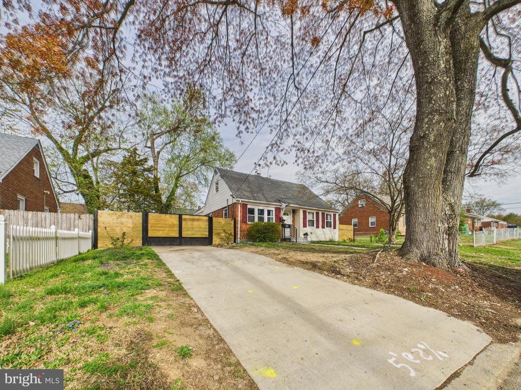
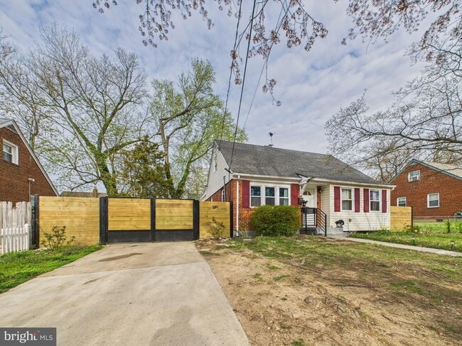
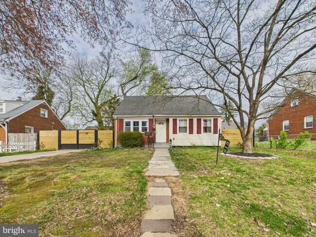
913 Brooke Rd
Capitol Heights, MD 20743
Today
Favorites
703-814-2026
-
Bedrooms
5
-
Bathrooms
3
-
Square Feet
--
-
Available
Available Now
Highlights
- Cape Cod Architecture
- 1 Fireplace
- Central Heating and Cooling System
913 Brooke Rd

Favorites
About This Home
Available Now
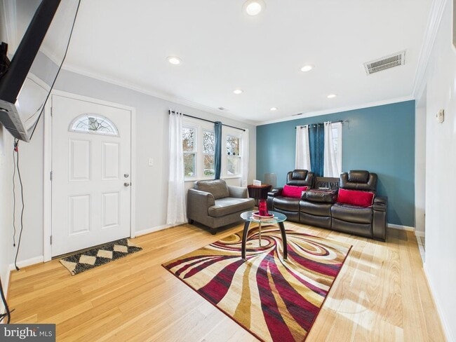
Welcome to this spacious 5-bedroom, 3-bathroom home, offering both comfort and convenience. Situated on a 5,000 square foot lot, this residence boasts a fantastic layout that accommodates a variety of living needs. It has a mix of hardwood floor in living room, carpet in bedrooms and tile in Kitchen area. Bedrooms are very spacious and with some having tons of natural light. Upstairs it has its own private bathroom and master suite. Home also comes with a very spacious parking driveway with its own private gate. The gate and fence have been recently updated. Home is five minute drive from Washington DC and three minute drive from Capital Heights metro station. There's plenty of shopping centers as well with different food restaurants. Schedule your appointment today.
913 Brooke Rd is a house located in Prince George's County and the 20743 ZIP Code. This area is served by the Prince George's County Public Schools attendance zone.
* Price shown is base rent and may not include non-optional fees and utilities.
Price, availability, fees, and any applicable rent special are subject to change without notice.
* Square footage definitions vary. Displayed square footage is approximate.
Home Details
Home Type
Single Family Detached Home
Year Built
Built in 1950
Bedrooms and Bathrooms
5 Bedrooms | 4 Main Level Bedrooms
3 Full Bathrooms
Home Design
Cape Cod Architecture
Brick Exterior Construction
Concrete Perimeter Foundation
Interior Spaces
1 Fireplace
1,551 Sq Ft Home
Property has 2 Levels
Listing and Financial Details
Security Deposit $2,995
12-Month Min and 24-Month Max Lease Term
Available 7/1/25
Assessor Parcel Number 17181999697
Residential Lease
Lot Details
5,200 Sq Ft Lot
Property is zoned RSF65
Parking
On-Street Parking
Driveway
Utilities
Central Heating and Cooling System
Electric Water Heater
Community Details
Overview
No Home Owners Association
Highview Subdivision
Pet Policy
Pets allowed on a case-by-case basis
Contact
- Listed by Elber Isaac Ramirez Olivo | First Decision Realty LLC
- Phone Number
- Contact
-
Source
 Bright MLS, Inc.
Copyright © 2025 Bright MLS, Inc.
Location
Get Directions
Amenities
- Fireplace
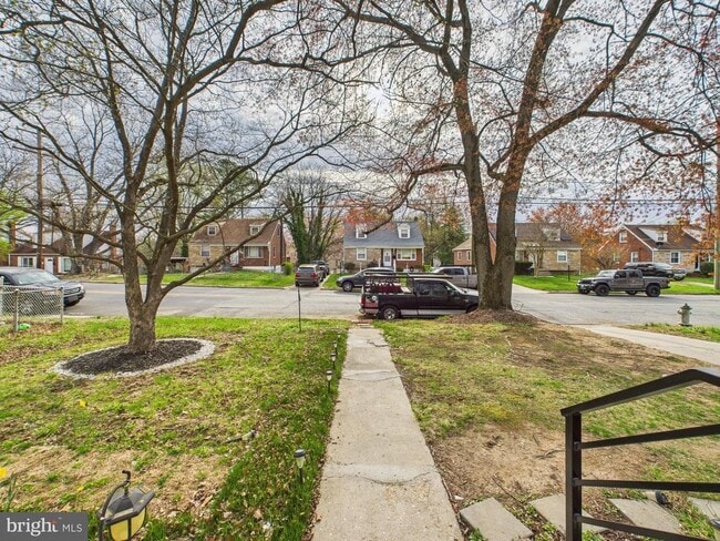
Capitol Heights -- named for its location near Washington, DC -- provides the perfect location: near DC, near the Capital Beltway, and minutes away from FedEx Field, home of the NFL's Washington Football Team. It is also close to the Anacostia River, the United States National Arboretum, and Joint Base Anacostia-Bolling. Nearby Fort Circle Park provides Capitol Heights residents with 10 miles of hiking trails -- it is also a popular concert venue and is home to Fort Dupont Ice Rink.
Capitol Heights is a terrific location for your DC-area apartment, only about seven miles southeast of downtown. Hop on the Metro at the Capitol Heights Metro Station for a fast, car-free commute. Despite being so close to the historic sites of DC, Capitol Heights was a rural area with no paved roads or streetlights. In 1910, the 200 residents in the area named their town "Capitol Heights," but it wasn't until 1980 and the arrival of the Metro Blue Line that the town began to grow.
Learn more about living in Capitol Heights
Education
| Colleges & Universities | Distance | ||
|---|---|---|---|
| Colleges & Universities | Distance | ||
| Drive: | 12 min | 5.8 mi | |
| Drive: | 11 min | 5.9 mi | |
| Drive: | 12 min | 6.6 mi | |
| Drive: | 13 min | 6.7 mi |
913 Brooke Rd is within 12 minutes or 5.8 miles from Gallaudet University. It is also near Univ. of Md. Univ. Coll. and Prince George's Comm. Coll..
Schools


Public Elementary School
Grades PK-5
289 Students
Attendance Zone
Public Elementary School
Grades PK-6
225 Students
Nearby
Public Middle School
Grades 6-8
693 Students
Attendance Zone
Public High School
Grades 9-12
877 Students
Attendance Zone
Private Elementary & Middle School
Grades PK-8
Nearby
Private High School
Grades 9-12
Nearby
School data provided by
 The GreatSchools Rating helps parents compare schools within a state based on a variety of school quality indicators and provides a helpful picture of how effectively each school serves all of its students. Ratings are on a scale of 1 (below average) to 10 (above average) and can include test scores, college readiness, academic progress, advanced courses, equity, discipline and attendance data. We also advise parents to visit schools, consider other information on school performance and programs, and consider family needs as part of the school selection process.
View GreatSchools Rating Methodology
Data provided by GreatSchools.org © 2025. All rights reserved.
View GreatSchools Rating Methodology
Data provided by GreatSchools.org © 2025. All rights reserved.
Transportation options available in Capitol Heights include Capitol Heights, Blue/Silver Line Center Platform, located 0.9 mile from 913 Brooke Rd. 913 Brooke Rd is near Ronald Reagan Washington Ntl, located 12.2 miles or 23 minutes away, and Baltimore/Washington International Thurgood Marshall, located 29.5 miles or 45 minutes away.
| Transit / Subway | Distance | ||
|---|---|---|---|
| Transit / Subway | Distance | ||
|
Capitol Heights, Blue/Silver Line Center Platform
|
Walk: | 18 min | 0.9 mi |
| Drive: | 3 min | 1.4 mi | |
| Drive: | 5 min | 2.2 mi | |
| Drive: | 7 min | 3.1 mi | |
| Drive: | 8 min | 3.5 mi |
| Commuter Rail | Distance | ||
|---|---|---|---|
| Commuter Rail | Distance | ||
|
|
Drive: | 11 min | 6.0 mi |
|
|
Drive: | 13 min | 6.2 mi |
|
|
Drive: | 13 min | 6.3 mi |
|
|
Drive: | 15 min | 8.6 mi |
| Drive: | 15 min | 8.6 mi |
| Airports | Distance | ||
|---|---|---|---|
| Airports | Distance | ||
|
Ronald Reagan Washington Ntl
|
Drive: | 23 min | 12.2 mi |
|
Baltimore/Washington International Thurgood Marshall
|
Drive: | 45 min | 29.5 mi |
Time and distance from 913 Brooke Rd.
| Shopping Centers | Distance | ||
|---|---|---|---|
| Shopping Centers | Distance | ||
| Drive: | 3 min | 1.1 mi | |
| Drive: | 5 min | 1.3 mi | |
| Drive: | 3 min | 1.3 mi |
913 Brooke Rd has 3 shopping centers within 1.3 miles, which is about a 3-minute drive. The miles and minutes will be for the farthest away property.
| Parks and Recreation | Distance | ||
|---|---|---|---|
| Parks and Recreation | Distance | ||
|
Fort Dupont Park
|
Drive: | 9 min | 3.3 mi |
|
Walker Mill Regional Park
|
Drive: | 7 min | 3.6 mi |
|
Kingman and Heritage Island Park
|
Drive: | 8 min | 4.0 mi |
|
Suitland Bog
|
Drive: | 9 min | 4.3 mi |
|
National Arboretum
|
Drive: | 14 min | 6.9 mi |
913 Brooke Rd has 5 parks within 6.9 miles, including Fort Dupont Park, Walker Mill Regional Park, and Kingman and Heritage Island Park.
| Hospitals | Distance | ||
|---|---|---|---|
| Hospitals | Distance | ||
| Drive: | 10 min | 4.6 mi | |
| Drive: | 16 min | 6.8 mi | |
| Drive: | 15 min | 6.9 mi |
913 Brooke Rd has 3 hospitals within 6.9 miles, the nearest is University of Maryland Prince George's Hospital Center which is 4.6 miles away and a 10 minute drive.
| Military Bases | Distance | ||
|---|---|---|---|
| Military Bases | Distance | ||
| Drive: | 14 min | 6.3 mi | |
| Drive: | 14 min | 7.0 mi |
913 Brooke Rd is 6.3 miles from Washington Navy Yard, and is convenient to other military bases, including Andrews Airforce Base.
You May Also Like
Similar Rentals Nearby


What Are Walk Score®, Transit Score®, and Bike Score® Ratings?
Walk Score® measures the walkability of any address. Transit Score® measures access to public transit. Bike Score® measures the bikeability of any address.
What is a Sound Score Rating?
A Sound Score Rating aggregates noise caused by vehicle traffic, airplane traffic and local sources

913 Brooke Rd
Capitol Heights, MD 20743