

$7,000
Total Monthly Price
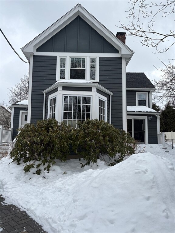
91 Eliot St
Brookline, MA 02467
Today
|
Edit
Favorites
860-560-1006
-
Bedrooms
3
-
Bathrooms
2.5
-
Square Feet
1,700 sq ft
-
Available
Available Now
91 Eliot St

Favorites
About This Home
$7,000 deposit,
Available Now
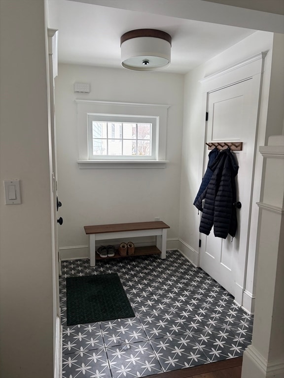
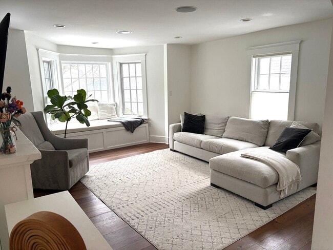
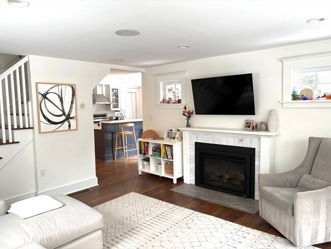
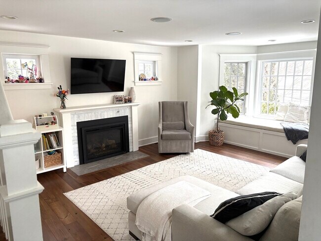
Renovated single family home in a great Brookline location and within walking distance of Roland Hayes School (K-8). Sun-filled living room and a lovely kitchen with sliders to patio. A first floor primary suite with a walk-in closet and bath with double sinks. Upstairs offers two spacious bedrooms,a den/hang out space/home office,second full bath,and a laundry room. One off street parking space. Close to Green line (D/C). Hayes School neighborhood. Convenient to Longwood Medical,Chestnut Hill,and Cleveland Circle. MLS# 73475824
91 Eliot St is a house located in Norfolk County and the 02467 ZIP Code.
* Price shown is total price based on community-supplied monthly required fees. Excludes user-selected optional fees and variable or usage-based fees and required charges due at or prior to move-in or at move-out. Price, availability, fees, and any applicable rent special are subject to change without notice.
* Square footage definitions vary. Displayed square footage is approximate.
Fees and Policies
The fees listed below are community-provided and may exclude utilities or add-ons. All payments are made directly to the property and are non-refundable unless otherwise specified. Use the Cost Calculator to determine costs based on your needs.
-
One-Time Basics
-
Due at Move-In
-
Security Deposit - RefundableCharged per unit.$7,000
-
-
Due at Move-In
Property Fee Disclaimer: Based on community-supplied data and independent market research. Subject to change without notice. May exclude fees for mandatory or optional services and usage-based utilities.
House Features
Microwave
Refrigerator
Disposal
Freezer
- Disposal
- Microwave
- Range
- Refrigerator
- Freezer
Contact
- Listed by Derek Greene | The Greene Realty Group
- Phone Number
-
Source
 MLS Property Information Network
The property listing data and information set forth herein were provided to MLS Property Information Network, Inc. from third party sources, including sellers, lessors and public records, and were compiled by MLS Property Information Network, Inc. The property listing data and information are for the personal, non-commercial use of consumers having a good faith interest in purchasing or leasing listed properties of the type displayed to them and may not be used for any purpose other than to identify prospective properties which such consumers may have a good faith interest in purchasing or leasing. MLS Property Information Network, Inc. and its subscribers disclaim any and all representations and warranties as to the accuracy of the property listing data and information set forth herein. All properties are subject to prior sale, change or withdrawal. Copyright © 2026 MLS Property Information Network, Inc. All rights reserved.
Location
Get Directions
Chestnut Hill Norfolk sits about five miles west of Downtown Boston and Cambridge. Traveling to and from the neighborhood is easy with access to multiple MBTA stations and buses, Route 9, and I-90. Boston Logan International Airport is just ten miles away as well.
Access to higher education, luxury retailers, and nature abound in Chestnut Hill Norfolk. Boston College, Pine Manor College, and Newbury College are all within close proximity to the neighborhood. All kinds of shopping and dining can be found at the Street at Chestnut Hill, the Shops at Chestnut Hill, and Chestnut Hill Square. Chestnut Hill Reservoir, Brookline Reservoir, Hammond Pond Reservation, Dane Park, and Lost Pond Conversation Area all offer opportunities to connect with nature and engage in outdoor recreation.
Learn more about living in Chestnut Hill Norfolk
Amenities
- Disposal
- Microwave
- Range
- Refrigerator
- Freezer
Education
| Colleges & Universities | Distance | ||
|---|---|---|---|
| Colleges & Universities | Distance | ||
| Drive: | 5 min | 1.7 mi | |
| Drive: | 4 min | 1.8 mi | |
| Drive: | 7 min | 3.6 mi | |
| Drive: | 7 min | 3.6 mi |
91 Eliot St is within 5 minutes or 1.7 miles from Boston College, Brighton. It is also near Boston College and Simmons College.
Transportation options available in Brookline include Reservoir Station, located 0.6 mile from 91 Eliot St. 91 Eliot St is near General Edward Lawrence Logan International, located 9.4 miles or 19 minutes away.
| Transit / Subway | Distance | ||
|---|---|---|---|
| Transit / Subway | Distance | ||
|
|
Walk: | 11 min | 0.6 mi |
|
|
Walk: | 15 min | 0.8 mi |
|
|
Walk: | 16 min | 0.8 mi |
|
|
Walk: | 16 min | 0.9 mi |
|
|
Walk: | 17 min | 0.9 mi |
| Commuter Rail | Distance | ||
|---|---|---|---|
| Commuter Rail | Distance | ||
|
|
Drive: | 8 min | 4.0 mi |
|
|
Drive: | 7 min | 4.1 mi |
|
|
Drive: | 9 min | 4.9 mi |
|
|
Drive: | 10 min | 5.0 mi |
| Drive: | 12 min | 5.5 mi |
| Airports | Distance | ||
|---|---|---|---|
| Airports | Distance | ||
|
General Edward Lawrence Logan International
|
Drive: | 19 min | 9.4 mi |
Time and distance from 91 Eliot St.
| Shopping Centers | Distance | ||
|---|---|---|---|
| Shopping Centers | Distance | ||
| Drive: | 3 min | 1.3 mi | |
| Drive: | 4 min | 1.4 mi | |
| Drive: | 3 min | 1.5 mi |
91 Eliot St has 3 shopping centers within 1.5 miles, which is about a 3-minute drive. The miles and minutes will be for the farthest away property.
| Parks and Recreation | Distance | ||
|---|---|---|---|
| Parks and Recreation | Distance | ||
|
Chestnut Hill Reservation
|
Walk: | 13 min | 0.7 mi |
|
Frederick Law Olmsted National Historic Site
|
Drive: | 3 min | 1.2 mi |
|
Hammond Pond Reservation
|
Drive: | 5 min | 2.3 mi |
|
John Fitzgerald Kennedy National Historic Site
|
Drive: | 5 min | 2.6 mi |
|
Arnold Arboretum of Harvard University
|
Drive: | 7 min | 4.1 mi |
91 Eliot St has 5 parks within 4.1 miles, including Chestnut Hill Reservation, Frederick Law Olmsted National Historic Site, and Hammond Pond Reservation.
| Hospitals | Distance | ||
|---|---|---|---|
| Hospitals | Distance | ||
| Drive: | 5 min | 2.2 mi | |
| Drive: | 5 min | 2.4 mi | |
| Drive: | 8 min | 2.9 mi |
91 Eliot St has 3 hospitals within 2.9 miles, the nearest is Franciscan Children's Hospital & Rehab Center which is 2.2 miles away and a 5 minute drive.
| Military Bases | Distance | ||
|---|---|---|---|
| Military Bases | Distance | ||
| Drive: | 23 min | 12.6 mi | |
| Drive: | 29 min | 16.3 mi |
91 Eliot St is 12.6 miles from US Military Reservation, and is convenient to other military bases, including Hanscom Air Force Base.
You May Also Like
Similar Rentals Nearby
-
-

-

-

-

-

-
 3 Beds, 2 Baths, 1,900 sq ft$4,000Total Monthly PriceTotal Monthly Price NewPrices include all required monthly fees.241 Perkins St
 -
 4 Beds, 1 Bath, 1,500 sq ft$3,600Total Monthly PriceTotal Monthly Price NewPrices include all required monthly fees.12 Dalrymple St
 -
 3 Beds, 1 Bath, 1,300 sq ft$2,900Total Monthly Price12 Month LeaseTotal Monthly Price NewPrices include all required monthly fees.133 Fayette St
 -
 3 Beds, 2 Baths, 1,126 sq ft$3,600Total Monthly Price12 Month LeaseTotal Monthly Price NewPrices include all required monthly fees.31 Cunningham St
What Are Walk Score®, Transit Score®, and Bike Score® Ratings?
Walk Score® measures the walkability of any address. Transit Score® measures access to public transit. Bike Score® measures the bikeability of any address.
What is a Sound Score Rating?
A Sound Score Rating aggregates noise caused by vehicle traffic, airplane traffic and local sources
91 Eliot St
Brookline, MA 02467