
$5,950 / Month
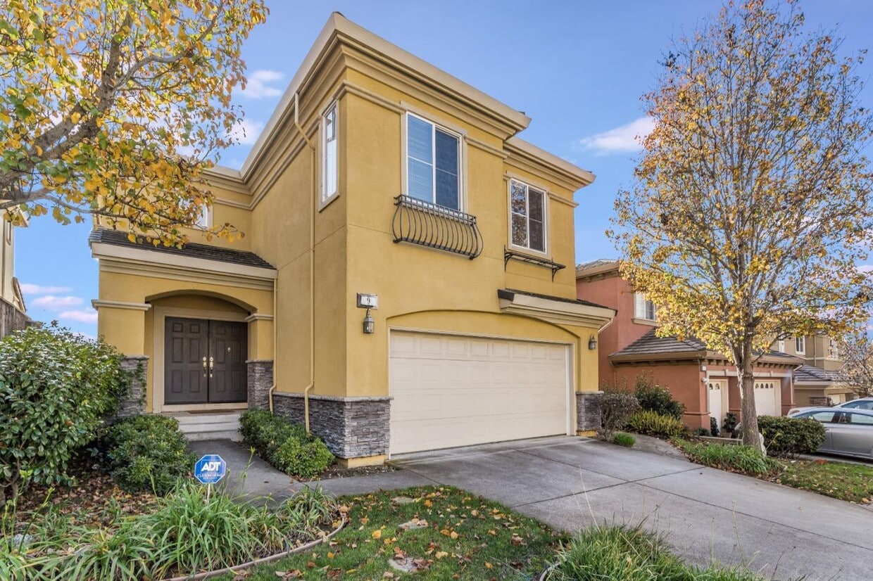
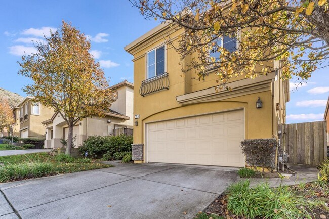
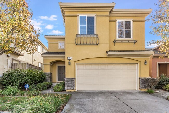
9 West Way
South San Francisco, CA 94080
2 Weeks Ago
Favorites
9 West Way

Favorites
Check Back Soon for Upcoming Availability
| Beds | Baths | Average SF |
|---|---|---|
| 4 Bedrooms 4 Bedrooms 4 Br | 3.5 Baths 3.5 Baths 3.5 Ba | 2,780 SF |
Fees and Policies
The fees below are based on community-supplied data and may exclude additional fees and utilities.
About This Property
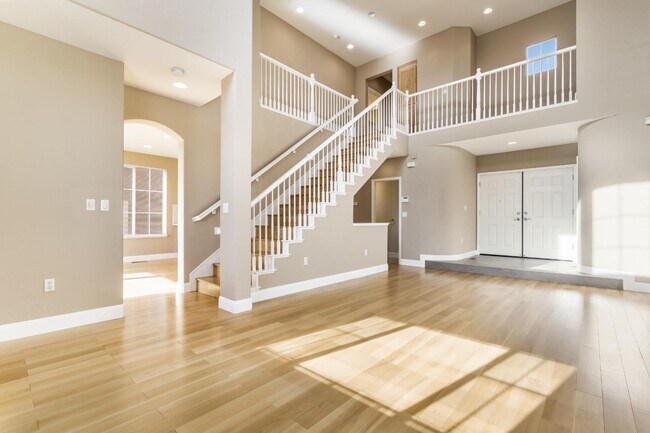
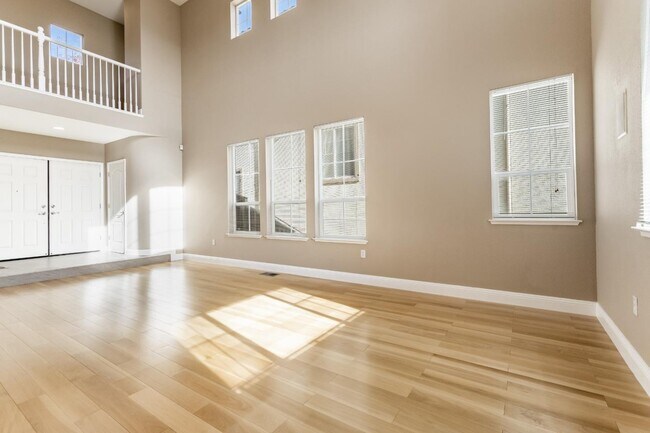
Welcome to this tri-level executive home in one of the South San Francisco's premier communities, Mandalay Heights. Enter on the main level into the inviting living room / dining area with high ceilings and large windows; allowing ample of natural sunlight. The lower level consist of a guest bedroom suite, additional den space and a large basement storage room. On the top floor, you'll find the luxurious master bedroom suite along with 2 additional bedrooms, a full hall bathroom and laundry room. Benefit from the stainless steel appliances (gas cooktop, refrigerator and dishwasher), 2 private decks, a private backyard, 2 car garage and 2 car driveway on a peaceful street. Enjoy gorgeous roof top views of the mountain side and the San Francisco Bay. Conveniently located to Bio-tech community, San Francisco International Airport, Highway 101, Costco Business Center and South San Francisco's Grand Avenue, where you'll find restaurants and local shops.
9 West Way is a house located in San Mateo County and the 94080 ZIP Code. This area is served by the South San Francisco Unified attendance zone.
House Features
- Fireplace
Location
Get Directions
Folks in South San Francisco have easy access to The City via I-280, the 101, or BART rail service. This fact, coupled with the much lower crime rate and the area’s many excellent schools, makes South San Francisco apartments an appealing option for commuters, particularly those raising families.
Although primarily a residential community, South San Francisco does have a fairly active downtown scene, with much of the dining and entertainment centered around the intersection of Grande Avenue and Linden Avenue and shopping centers on the south side of town.
Many parks and nature preserves are scattered around the area, including the huge Sweeney Ridge and Fairway Park just to the west of the city limits. San Francisco International Airport sits directly south of town, making it highly convenient to travel anywhere.
Learn more about living in South San Francisco
Amenities
- Fireplace
Education
| Colleges & Universities | Distance | ||
|---|---|---|---|
| Colleges & Universities | Distance | ||
| Drive: | 13 min | 5.8 mi | |
| Drive: | 17 min | 7.4 mi | |
| Drive: | 13 min | 8.6 mi | |
| Drive: | 14 min | 9.0 mi |
9 West Way is within 13 minutes or 5.8 miles from Skyline College. It is also near City College of San Francisco and San Francisco State University.
Schools


Public Elementary School
Grades K-5
Nearby
Public Elementary School
Grades K-5
334 Students
Attendance Zone
Public Middle School
Grades 6-8
612 Students
Attendance Zone
Public High School
Grades 9-12
1,280 Students
Attendance Zone
Private Elementary, Middle & High School
Grades 1-12
Nearby
Private Elementary & Middle School
Grades K-8
265 Students
Nearby
Private Elementary School
Grades PK-2
105 Students
Nearby
School data provided by
 The GreatSchools Rating helps parents compare schools within a state based on a variety of school quality indicators and provides a helpful picture of how effectively each school serves all of its students. Ratings are on a scale of 1 (below average) to 10 (above average) and can include test scores, college readiness, academic progress, advanced courses, equity, discipline and attendance data. We also advise parents to visit schools, consider other information on school performance and programs, and consider family needs as part of the school selection process.
View GreatSchools Rating Methodology
Data provided by GreatSchools.org © 2025. All rights reserved.
View GreatSchools Rating Methodology
Data provided by GreatSchools.org © 2025. All rights reserved.
Transportation options available in South San Francisco include South San Francisco Station, located 2.5 miles from 9 West Way. 9 West Way is near San Francisco International, located 5.3 miles or 11 minutes away, and Metro Oakland International, located 28.1 miles or 42 minutes away.
| Transit / Subway | Distance | ||
|---|---|---|---|
| Transit / Subway | Distance | ||
|
|
Drive: | 7 min | 2.5 mi |
|
|
Drive: | 7 min | 2.5 mi |
| Drive: | 8 min | 3.2 mi | |
|
|
Drive: | 8 min | 3.5 mi |
| Drive: | 8 min | 4.2 mi |
| Commuter Rail | Distance | ||
|---|---|---|---|
| Commuter Rail | Distance | ||
| Drive: | 4 min | 1.8 mi | |
| Drive: | 7 min | 3.8 mi | |
| Drive: | 9 min | 4.1 mi | |
| Drive: | 10 min | 6.2 mi | |
| Drive: | 11 min | 7.2 mi |
| Airports | Distance | ||
|---|---|---|---|
| Airports | Distance | ||
|
San Francisco International
|
Drive: | 11 min | 5.3 mi |
|
Metro Oakland International
|
Drive: | 42 min | 28.1 mi |
Time and distance from 9 West Way.
| Shopping Centers | Distance | ||
|---|---|---|---|
| Shopping Centers | Distance | ||
| Drive: | 6 min | 2.3 mi | |
| Drive: | 6 min | 2.4 mi | |
| Drive: | 6 min | 2.6 mi |
9 West Way has 3 shopping centers within 2.6 miles, which is about a 6-minute drive. The miles and minutes will be for the farthest away property.
| Parks and Recreation | Distance | ||
|---|---|---|---|
| Parks and Recreation | Distance | ||
|
Candlestick Point State Recreation Area
|
Drive: | 13 min | 5.8 mi |
|
San Bruno Mountain State Park
|
Drive: | 16 min | 6.9 mi |
|
Charles F. Hagar Planetarium
|
Drive: | 18 min | 8.1 mi |
|
San Francisco State Univ. Observatory
|
Drive: | 18 min | 8.1 mi |
|
Heron's Head Park
|
Drive: | 14 min | 8.5 mi |
9 West Way has 5 parks within 8.5 miles, including San Bruno Mountain State Park, Candlestick Point State Recreation Area, and Charles F. Hagar Planetarium.
| Hospitals | Distance | ||
|---|---|---|---|
| Hospitals | Distance | ||
| Drive: | 6 min | 2.5 mi | |
| Drive: | 11 min | 4.8 mi | |
| Drive: | 10 min | 6.4 mi |
9 West Way has 3 hospitals within 6.4 miles, the nearest is Kaiser Foundation Hospital - South San Francisco which is 2.5 miles away and a 6 minute drive.
| Military Bases | Distance | ||
|---|---|---|---|
| Military Bases | Distance | ||
| Drive: | 29 min | 12.0 mi | |
| Drive: | 38 min | 22.7 mi |
9 West Way is 12.0 miles from East Fort Miley, and is convenient to other military bases, including Alameda/US Naval Air Station San Francisco.
You May Also Like
Similar Rentals Nearby


What Are Walk Score®, Transit Score®, and Bike Score® Ratings?
Walk Score® measures the walkability of any address. Transit Score® measures access to public transit. Bike Score® measures the bikeability of any address.
What is a Sound Score Rating?
A Sound Score Rating aggregates noise caused by vehicle traffic, airplane traffic and local sources

9 West Way
South San Francisco, CA 94080