


$4,700
Total Monthly Price
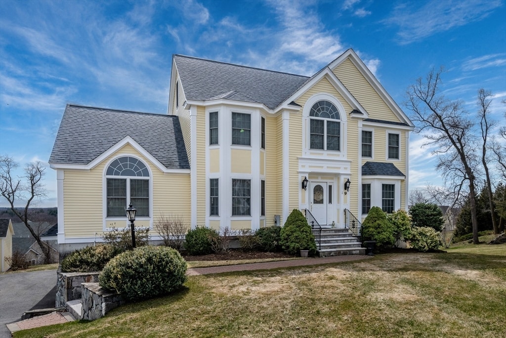
9 Kettle Way
Dracut, MA 01826
Favorites
978-423-2578
-
Bedrooms
4
-
Bathrooms
2.5
-
Square Feet
2,783 sq ft
-
Available
Available Now
Highlights
- Golf Course Community
- Deck
- Property is near public transit
- 1 Fireplace
- Game Room
- Jogging Path
9 Kettle Way

Favorites
About This Home
$4,700 deposit,
Available Now
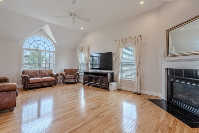
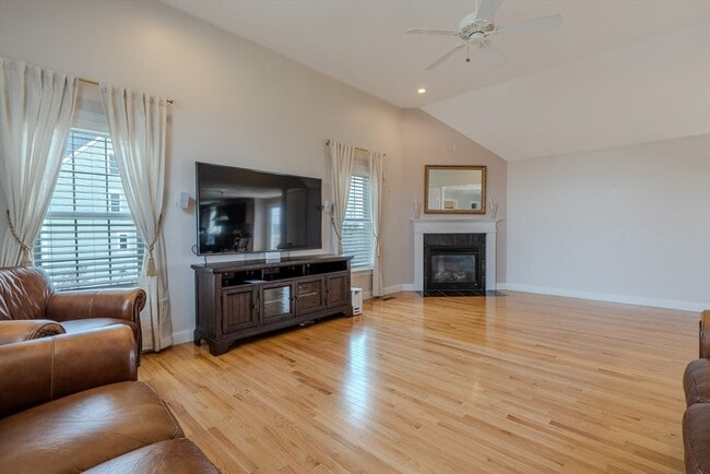
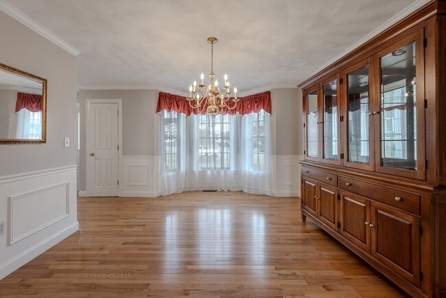
This 4 bedroom,2.5 bath home is available for immediate occupancy. The house is partially furnished on a cul de sac. Two car garage with finished basement and pool table. Large deck off the kitchen overlooking the back yard. MLS ID 73494520
9 Kettle Way is a house located in Middlesex County and the 01826 ZIP Code. This area is served by the Dracut School District attendance zone.
* Price shown is total price based on community-supplied monthly required fees. Excludes user-selected optional fees and variable or usage-based fees and required charges due at or prior to move-in or at move-out. Price, availability, fees, and any applicable rent special are subject to change without notice.
* Square footage definitions vary. Displayed square footage is approximate.
Home Details
Home Type
Single Family Detached Home
Year Built
Built in 2005
Bedrooms and Bathrooms
Primary bedroom located on second floor
2.5 Bathrooms
4 Bedrooms
Home Design
Entry on the 1st floor
Interior Spaces
1 Fireplace
Game Room
2,783 Sq Ft Home
Kitchen
Range
Microwave
Dishwasher
Laundry
Laundry on main level
Listing and Financial Details
Security Deposit $4,700
Assessor Parcel Number M:37 B:41 L:12,4405448
Rent includes water, snow removal, gardener, furnishings (see remarks)
Location
Property is near public transit
Lot Details
20,211 Sq Ft Lot
Outdoor Features
Deck
Parking
4 Open Parking Spaces
4 Car Parking Spaces
Utilities
No Cooling
Heating System Uses Natural Gas
Community Details
Amenities
Shops
Overview
Property has a Home Owners Association
Pet Policy
No Pets Allowed
Recreation
Golf Course Community
Jogging Path
Park
Fees and Policies
The fees listed below are community-provided and may exclude utilities or add-ons. All payments are made directly to the property and are non-refundable unless otherwise specified. Use the Cost Calculator to determine costs based on your needs.
-
One-Time Basics
-
Due at Move-In
-
Security Deposit - RefundableCharged per unit.$4,700
-
-
Due at Move-In
Property Fee Disclaimer: Based on community-supplied data and independent market research. Subject to change without notice. May exclude fees for mandatory or optional services and usage-based utilities.
Contact
- Listed by Dan O'Connell Sr | LAER Realty Partners
- Phone Number
-
Source
 MLS Property Information Network
The property listing data and information set forth herein were provided to MLS Property Information Network, Inc. from third party sources, including sellers, lessors and public records, and were compiled by MLS Property Information Network, Inc. The property listing data and information are for the personal, non-commercial use of consumers having a good faith interest in purchasing or leasing listed properties of the type displayed to them and may not be used for any purpose other than to identify prospective properties which such consumers may have a good faith interest in purchasing or leasing. MLS Property Information Network, Inc. and its subscribers disclaim any and all representations and warranties as to the accuracy of the property listing data and information set forth herein. All properties are subject to prior sale, change or withdrawal. Copyright © 2026 MLS Property Information Network, Inc. All rights reserved.
Location
Get Directions
The city of Dracut is settled on the Massachusetts-New Hampshire state line to the north and the Merrimack River to the south. This riverfront suburb offers a quaint, peaceful atmosphere with a park-like environment that you’re sure to enjoy.
Though the residential streets of Dracut are calm, once you take a leap over the Merrimack River, you’ll be in Downtown Lowell where you’ll discover historic museums, galleries, restaurants, shops, and more! Situated 32 miles northwest of Boston, Dracut is far enough from the hustle and bustle of urban living while still being in easy driving distance. Directly north of the University of Massachusetts Lowell, the city has a youthful vibe that comes from this popular university just minutes from your potential new home.
To the east, Dracut shares a portion of national state forest with its neighboring cities of Lowell and Tyngsborough.
Learn more about living in Dracut
Amenities
- Dishwasher
- Microwave
- Range
- Refrigerator
- Deck
Education
| Colleges & Universities | Distance | ||
|---|---|---|---|
| Colleges & Universities | Distance | ||
| Drive: | 7 min | 3.1 mi | |
| Drive: | 7 min | 3.7 mi | |
| Drive: | 26 min | 12.8 mi | |
| Drive: | 23 min | 13.4 mi |
9 Kettle Way is within 7 minutes or 3.1 miles from Middlesex C.C., Lowell Campus. It is also near UMass Lowell and Merrimack College.
Schools


Public Elementary School
Grades PK-5
569 Students
Attendance Zone
Public Elementary School
Grades K-5
202 Students
Nearby
Public Middle School
Grades 6-8
940 Students
Attendance Zone
Public High School
Grades 9-12
763 Students
Attendance Zone
Public High School
Grades 9-12
763 Students
Nearby
Private Elementary School
Grades PK-5
7 Students
Nearby
Private Elementary, Middle & High School
Grades K-12
2 Students
Nearby
School data provided by
 The GreatSchools Rating helps parents compare schools within a state based on a variety of school quality indicators and provides a helpful picture of how effectively each school serves all of its students. Ratings are on a scale of 1 (below average) to 10 (above average) and can include test scores, college readiness, academic progress, advanced courses, equity, discipline and attendance data. We also advise parents to visit schools, consider other information on school performance and programs, and consider family needs as part of the school selection process.
View GreatSchools Rating Methodology
Data provided by GreatSchools.org © 2026. All rights reserved.
View GreatSchools Rating Methodology
Data provided by GreatSchools.org © 2026. All rights reserved.
Getting Around
 What do Walkability, Transit, Drivability, and Bikeability mean?
Walkability measures the walking distance to day-to-day needs.
Transit measures access to public transportation.
Drivability measures congestion, parking availability, and access to major roads.
Bikeability measures the suitability for cycling.
How It Works
What do Walkability, Transit, Drivability, and Bikeability mean?
Walkability measures the walking distance to day-to-day needs.
Transit measures access to public transportation.
Drivability measures congestion, parking availability, and access to major roads.
Bikeability measures the suitability for cycling.
How It Works
Somewhat Walkable
Walkability
30
/ 100
Minimal Public Transit
Transit
0
/ 100
Exceptionally Drivable
Drivability
90
/ 100
Fairly Bikeable
Bikeability
40
/ 100
Scores provided by
-
Soundscore™
-
/ 100
Traffic
-Airport
-Businesses
-Scores provided by
HowLoud What is a Sound Score Rating? A Sound Score Rating aggregates noise caused by vehicle traffic, airplane traffic and local sources. How It WorksYou May Also Like
Similar Rentals Nearby
-
-

-

-

-

-

-
 4 Beds, 3 Baths, 2,400 sq ft$5,000Total Monthly Price12 Month LeaseTotal Monthly Price NewPrices include all required monthly fees.39 Locust St
 -
 6 Beds, 7 Baths, 8,866 sq ft$15,000Total Monthly PriceTotal Monthly Price NewPrices include all required monthly fees.20 Amberwood Dr
 -
 4 Beds, 2 Baths, 2,699 sq ft$5,000Total Monthly PriceTotal Monthly Price NewPrices include all required monthly fees.19 Downing Rd
 -
 4 Beds, 4 Baths, 3,526 sq ft$8,500Total Monthly Price12 Month LeaseTotal Monthly Price NewPrices include all required monthly fees.31 Woodcliffe Rd
What Are Walk Score®, Transit Score®, and Bike Score® Ratings?
Walk Score® measures the walkability of any address. Transit Score® measures access to public transit. Bike Score® measures the bikeability of any address.
What is a Sound Score Rating?
A Sound Score Rating aggregates noise caused by vehicle traffic, airplane traffic and local sources.
9 Kettle Way
Dracut, MA 01826