
Venue Residences
3688 Overland Ave,
Los Angeles, CA 90034
$2,625 - $5,650
Studio - 2 Beds
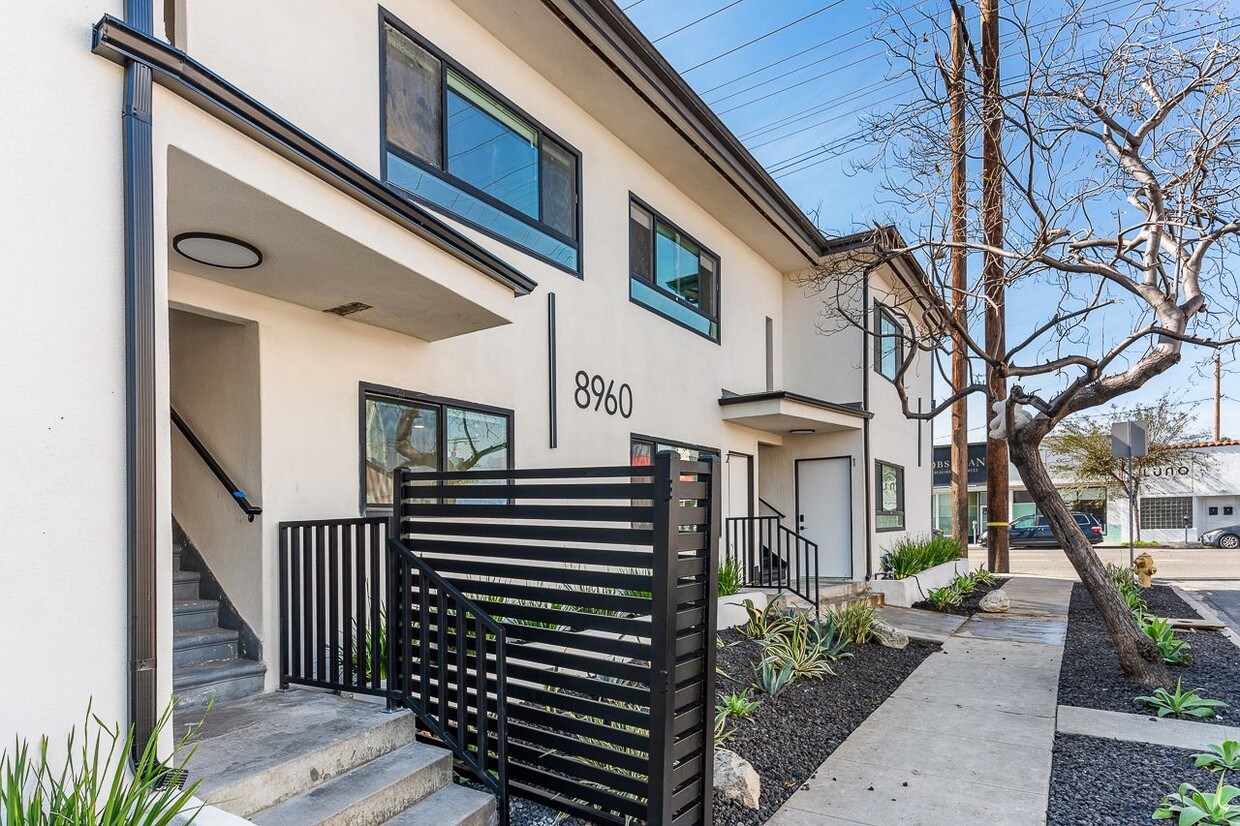

Welcome to 8960 Hargis St in Los Angeles, CA. This community is located in the Beverlywood area of Los Angeles. Let the professional leasing staff show you everything this community has to offer. Give us a call now to learn more about our community.
8960 Hargis St is an apartment community located in Los Angeles County and the 90034 ZIP Code. This area is served by the Los Angeles Unified Rocp School District attendance zone.
Washer/Dryer
Dishwasher
Hardwood Floors
Island Kitchen
Beverlywood is a welcoming neighborhood located directly south of Beverly Hills in Los Angeles. The community feels very homey, with many residents having lived in the area for years or even decades. Much of Beverlywood is an incorporated community, so residents enjoy access to private parks and a high standard of living. Well-maintained streets, picturesque landscaping, and charming homes define this neighborhood. Residents enjoy proximity to the Hillcrest Country Club, the Rancho Park Golf Club, the Museum of Jurassic Technology, and Rodeo Drive. Those renting upscale apartments in Beverlywood have easy access to the entire west side of Los Angeles, with its great shopping, dining, and entertainment options.
Learn more about living in BeverlywoodCompare neighborhood and city base rent averages by bedroom.
| Beverlywood | Los Angeles, CA | |
|---|---|---|
| Studio | $2,192 | $1,711 |
| 1 Bedroom | $2,623 | $2,183 |
| 2 Bedrooms | $3,788 | $3,016 |
| 3 Bedrooms | $5,304 | $4,340 |
| Colleges & Universities | Distance | ||
|---|---|---|---|
| Colleges & Universities | Distance | ||
| Drive: | 8 min | 2.9 mi | |
| Drive: | 9 min | 5.1 mi | |
| Drive: | 8 min | 5.1 mi | |
| Drive: | 9 min | 5.4 mi |


Transportation options available in Los Angeles include Culver City, located 0.6 mile from 8960 Hargis St. 8960 Hargis St is near Los Angeles International, located 8.2 miles or 16 minutes away, and Bob Hope, located 15.3 miles or 30 minutes away.
| Transit / Subway | Distance | ||
|---|---|---|---|
| Transit / Subway | Distance | ||
|
|
Walk: | 11 min | 0.6 mi |
|
|
Drive: | 2 min | 1.3 mi |
|
|
Drive: | 3 min | 1.6 mi |
|
|
Drive: | 5 min | 2.6 mi |
|
|
Drive: | 5 min | 2.8 mi |
| Commuter Rail | Distance | ||
|---|---|---|---|
| Commuter Rail | Distance | ||
|
|
Drive: | 16 min | 10.7 mi |
|
|
Drive: | 18 min | 10.8 mi |
|
|
Drive: | 27 min | 13.2 mi |
|
|
Drive: | 22 min | 14.1 mi |
|
|
Drive: | 29 min | 14.1 mi |
| Airports | Distance | ||
|---|---|---|---|
| Airports | Distance | ||
|
Los Angeles International
|
Drive: | 16 min | 8.2 mi |
|
Bob Hope
|
Drive: | 30 min | 15.3 mi |
Scores provided by
Traffic
-Airport
-Businesses
-Scores provided by
HowLoud What is a Sound Score Rating? A Sound Score Rating aggregates noise caused by vehicle traffic, airplane traffic and local sources. How It WorksTime and distance from 8960 Hargis St.
| Shopping Centers | Distance | ||
|---|---|---|---|
| Shopping Centers | Distance | ||
| Walk: | 13 min | 0.7 mi | |
| Walk: | 14 min | 0.7 mi | |
| Walk: | 14 min | 0.8 mi |
| Parks and Recreation | Distance | ||
|---|---|---|---|
| Parks and Recreation | Distance | ||
|
Zimmer Children's Museum
|
Drive: | 7 min | 3.2 mi |
|
La Brea Tar Pits
|
Drive: | 7 min | 3.4 mi |
|
Kenneth Hahn State Recreation Area
|
Drive: | 10 min | 3.6 mi |
|
Ballona Creek Trail - Ballona Wetlands Ecological Reserve Access
|
Drive: | 9 min | 4.1 mi |
|
Mathias Botanical Garden
|
Drive: | 10 min | 5.8 mi |
| Hospitals | Distance | ||
|---|---|---|---|
| Hospitals | Distance | ||
| Walk: | 17 min | 0.9 mi | |
| Drive: | 6 min | 2.8 mi | |
| Drive: | 6 min | 2.9 mi |
| Military Bases | Distance | ||
|---|---|---|---|
| Military Bases | Distance | ||
| Drive: | 17 min | 10.7 mi | |
| Drive: | 39 min | 27.5 mi | |
| Drive: | 42 min | 29.7 mi |
Pets Allowed In Unit Washer & Dryer Maintenance on site Heat Controlled Access Elevator
What Are Walk Score®, Transit Score®, and Bike Score® Ratings?
Walk Score® measures the walkability of any address. Transit Score® measures access to public transit. Bike Score® measures the bikeability of any address.
What is a Sound Score Rating?
A Sound Score Rating aggregates noise caused by vehicle traffic, airplane traffic and local sources.

8960 Hargis St
Los Angeles, CA 90034


