
Nova by Gomes
1213-1221 Broad St,
Newark, NJ 07114
$2,054 - $3,000
Studio - 2 Beds
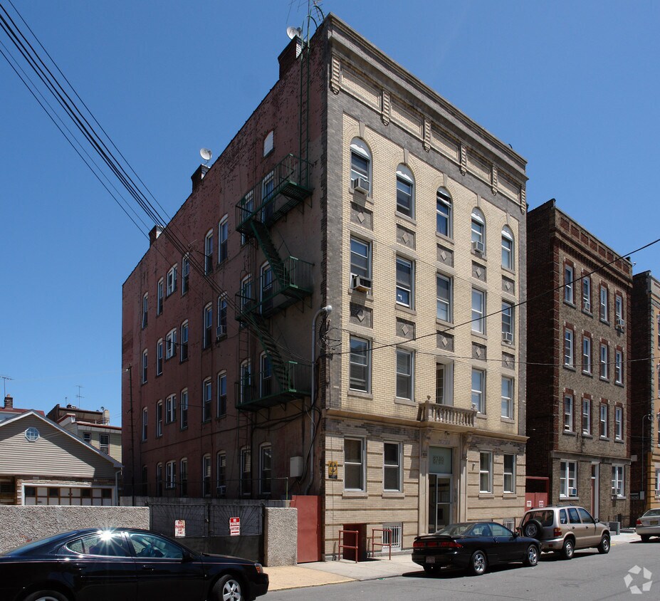
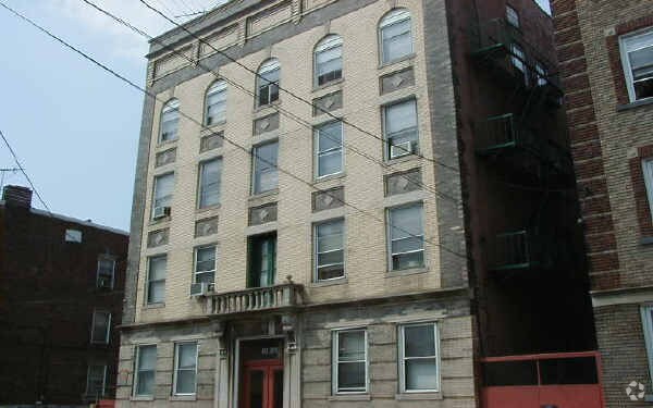
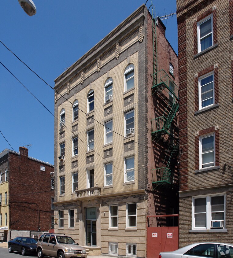

Discover 87-89 Nichols St in Newark. This apartment community is located on Nichols St. in the 07105 area of Newark. The professional leasing team is ready and waiting for you to come by to check us out. Be sure to come for a visit to check out the apartment floorplan options. Get a head start on moving now. Contact or stop by the 87-89 Nichols St leasing office to check the current floorplan availability today.
87-89 Nichols St is an apartment community located in Essex County and the 07105 ZIP Code. This area is served by the The Newark Public School District attendance zone.
When you put Newark’s Prudential Center and the Red Bull Arena within walking distance of one of the best dining meccas in New Jersey, you get the North Ironbound district. North Ironbound sits just off Downtown Newark and stretches to Newark Bay. This neighborhood is a diverse suburb with a close-knit community. Abundant restaurants and shops are spread throughout the area, many lined along Ferry Street and Elm Street. Nestled along the Passaic River, residents enjoy waterfront views and sweeping views of the city from places like Riverbank Park. North Ironbound is very family-friendly, offering safe streets and good public schools.
North Ironbound is the perfect place for those who work or go to school in Newark. The district is located directly north of the Newark Liberty International Airport and offers easy access to an array of major roadways, including Interstates 78 and 95.
Learn more about living in North IronboundCompare neighborhood and city base rent averages by bedroom.
| North Ironbound | Newark, NJ | |
|---|---|---|
| Studio | $2,089 | $1,365 |
| 1 Bedroom | $2,427 | $1,611 |
| 2 Bedrooms | $2,802 | $2,024 |
| 3 Bedrooms | $3,151 | $2,121 |
| Colleges & Universities | Distance | ||
|---|---|---|---|
| Colleges & Universities | Distance | ||
| Drive: | 4 min | 1.8 mi | |
| Drive: | 4 min | 1.9 mi | |
| Drive: | 5 min | 2.1 mi | |
| Drive: | 12 min | 5.6 mi |


Transportation options available in Newark include Military Park, located 1.4 miles from 87-89 Nichols St. 87-89 Nichols St is near Newark Liberty International, located 3.8 miles or 7 minutes away, and LaGuardia, located 19.7 miles or 41 minutes away.
| Transit / Subway | Distance | ||
|---|---|---|---|
| Transit / Subway | Distance | ||
|
|
Drive: | 3 min | 1.4 mi |
|
|
Drive: | 3 min | 1.6 mi |
|
|
Drive: | 4 min | 1.8 mi |
|
|
Drive: | 4 min | 1.9 mi |
|
|
Drive: | 4 min | 1.9 mi |
| Commuter Rail | Distance | ||
|---|---|---|---|
| Commuter Rail | Distance | ||
|
|
Drive: | 3 min | 1.2 mi |
|
|
Walk: | 27 min | 1.4 mi |
|
|
Drive: | 6 min | 2.9 mi |
|
|
Drive: | 9 min | 3.8 mi |
|
|
Drive: | 9 min | 3.8 mi |
| Airports | Distance | ||
|---|---|---|---|
| Airports | Distance | ||
|
Newark Liberty International
|
Drive: | 7 min | 3.8 mi |
|
LaGuardia
|
Drive: | 41 min | 19.7 mi |
Scores provided by
Traffic
-Airport
-Businesses
-Scores provided by
HowLoud What is a Sound Score Rating? A Sound Score Rating aggregates noise caused by vehicle traffic, airplane traffic and local sources. How It WorksTime and distance from 87-89 Nichols St.
| Shopping Centers | Distance | ||
|---|---|---|---|
| Shopping Centers | Distance | ||
| Walk: | 17 min | 0.9 mi | |
| Walk: | 18 min | 1.0 mi |
| Parks and Recreation | Distance | ||
|---|---|---|---|
| Parks and Recreation | Distance | ||
|
Newark Museum and Dreyfuss Planetarium
|
Drive: | 4 min | 1.8 mi |
|
Branch Brook Park
|
Drive: | 9 min | 3.9 mi |
|
Kearny Marsh
|
Drive: | 9 min | 3.9 mi |
|
Stephen Gregg Park
|
Drive: | 13 min | 7.2 mi |
|
Richard W. DeKorte Park
|
Drive: | 15 min | 7.3 mi |
| Hospitals | Distance | ||
|---|---|---|---|
| Hospitals | Distance | ||
| Drive: | 4 min | 1.9 mi | |
| Drive: | 5 min | 2.6 mi | |
| Drive: | 8 min | 4.0 mi |
| Military Bases | Distance | ||
|---|---|---|---|
| Military Bases | Distance | ||
| Drive: | 13 min | 7.7 mi | |
| Drive: | 24 min | 11.9 mi | |
| Drive: | 30 min | 17.4 mi |
What Are Walk Score®, Transit Score®, and Bike Score® Ratings?
Walk Score® measures the walkability of any address. Transit Score® measures access to public transit. Bike Score® measures the bikeability of any address.
What is a Sound Score Rating?
A Sound Score Rating aggregates noise caused by vehicle traffic, airplane traffic and local sources.


