

$1,900 / Month
8680 Corcoran Path
Inver Grove Heights, MN 55076
2 Weeks Ago
Favorites
8680 Corcoran Path

Favorites
Check Back Soon for Upcoming Availability
| Beds | Baths | Average SF |
|---|---|---|
| 2 Bedrooms 2 Bedrooms 2 Br | 1.5 Baths 1.5 Baths 1.5 Ba | 1,402 SF |
About This Property
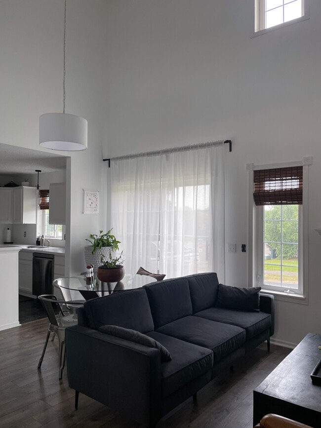
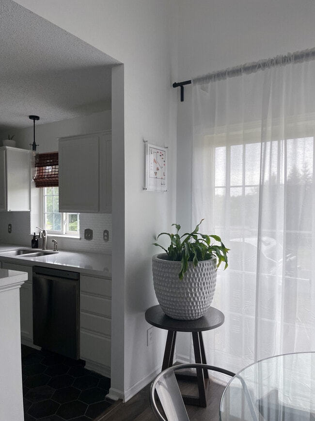
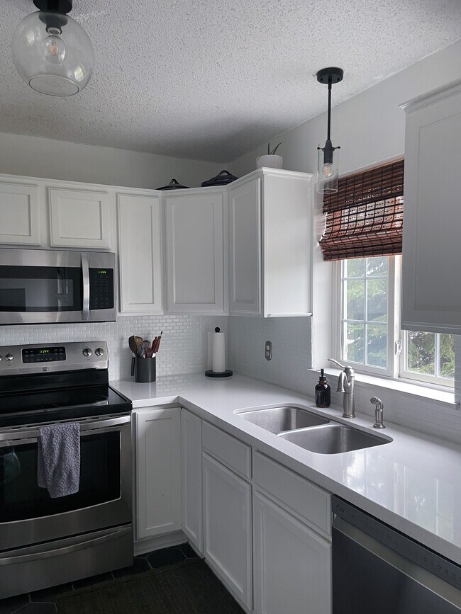
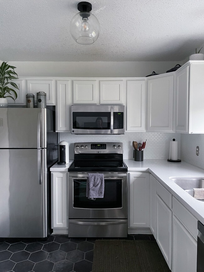
Home is calling! This beautiful modern high ceiling open floor plan 2 bedroom, 1.5 bathroom, 2 car garage house in Inver Grove Heights is available. Amenities included: balcony, central air, central heat, new dishwasher, hardwood floors, stainless steel appliance, updated kitchen, updated bathroom, and new washer dryer. No Utilities included. Is not pet friendly. Walking distance to parks and beautiful walking trails. Easily commute. *full loft and second bedroom not pictured. *semi-furnished options available. Date Available: Nov 1st 2022. $2,500/month rent. $2,500 security deposit required. Please submit the form on this page. This property is managed by a responsible landlord using Avail landlord software.
8680 Corcoran Path is a house located in Dakota County and the 55076 ZIP Code. This area is served by the Inver Grove Heights Schools attendance zone.
House Features
- Washer/Dryer
- Washer/Dryer Hookup
- Dishwasher
Location
Get Directions
Just off the eastern bank of the Mississippi River, Inver Grove Heights, Minnesota has all the natural beauty expected from the state known for its grassy rolling plains. South of the Twin Cities, Inver Grove Heights is a suburb of Saint Paul. This residential city provides easy access to the surrounding areas thanks to the highway that runs through the city, Highway 52.
Residents of this quiet town enjoy several events and volunteer opportunities that keeps people of Inver Grove Heights connected. There are also many local parks and a community center that provides the community with a variety of recreation opportunities and programs. The new development within the area makes Inver Grove a city with a pleasant mix of both old and new.
Learn more about living in Inver Grove Heights
Amenities
- Washer/Dryer
- Washer/Dryer Hookup
- Dishwasher
Education
| Colleges & Universities | Distance | ||
|---|---|---|---|
| Colleges & Universities | Distance | ||
| Drive: | 6 min | 2.2 mi | |
| Drive: | 14 min | 8.9 mi | |
| Drive: | 17 min | 12.1 mi | |
| Drive: | 19 min | 12.6 mi |
8680 Corcoran Path is within 6 minutes or 2.2 miles from Inver Hills Community College. It is also near Argosy University, Twin Cities and Saint Paul College.
Schools


Public Elementary School
Grades PK-5
271 Students
Nearby
Public Elementary School
Grades PK-5
535 Students
Attendance Zone
Public Middle School
Grades 6-8
761 Students
Attendance Zone
Public High School
Grades 9-12
1,062 Students
Attendance Zone
Private Elementary, Middle & High School
Grades PK-12
40 Students
Nearby
Private Elementary School
Grades PK-6
24 Students
Nearby
School data provided by
 The GreatSchools Rating helps parents compare schools within a state based on a variety of school quality indicators and provides a helpful picture of how effectively each school serves all of its students. Ratings are on a scale of 1 (below average) to 10 (above average) and can include test scores, college readiness, academic progress, advanced courses, equity, discipline and attendance data. We also advise parents to visit schools, consider other information on school performance and programs, and consider family needs as part of the school selection process.
View GreatSchools Rating Methodology
Data provided by GreatSchools.org © 2025. All rights reserved.
View GreatSchools Rating Methodology
Data provided by GreatSchools.org © 2025. All rights reserved.
Transportation options available in Inver Grove Heights include Central Station, located 11.4 miles from 8680 Corcoran Path. 8680 Corcoran Path is near Minneapolis-St Paul International/Wold-Chamberlain, located 13.2 miles or 20 minutes away.
| Transit / Subway | Distance | ||
|---|---|---|---|
| Transit / Subway | Distance | ||
| Drive: | 17 min | 11.4 mi | |
| Drive: | 17 min | 11.5 mi | |
| Drive: | 17 min | 11.6 mi | |
| Drive: | 18 min | 12.0 mi | |
|
|
Drive: | 18 min | 12.2 mi |
| Commuter Rail | Distance | ||
|---|---|---|---|
| Commuter Rail | Distance | ||
|
|
Drive: | 17 min | 11.7 mi |
|
|
Drive: | 33 min | 18.6 mi |
|
|
Drive: | 38 min | 28.2 mi |
|
|
Drive: | 48 min | 36.3 mi |
|
|
Drive: | 52 min | 38.3 mi |
| Airports | Distance | ||
|---|---|---|---|
| Airports | Distance | ||
|
Minneapolis-St Paul International/Wold-Chamberlain
|
Drive: | 20 min | 13.2 mi |
Time and distance from 8680 Corcoran Path.
| Shopping Centers | Distance | ||
|---|---|---|---|
| Shopping Centers | Distance | ||
| Walk: | 17 min | 0.9 mi | |
| Walk: | 20 min | 1.1 mi | |
| Drive: | 4 min | 1.6 mi |
8680 Corcoran Path has 3 shopping centers within 1.6 miles, which is about a 4-minute walk. The miles and minutes will be for the farthest away property.
| Parks and Recreation | Distance | ||
|---|---|---|---|
| Parks and Recreation | Distance | ||
|
Spring Lake Reserve
|
Drive: | 15 min | 8.6 mi |
|
Dodge Nature Center
|
Drive: | 14 min | 8.7 mi |
|
Crosby Farm Regional Park
|
Drive: | 17 min | 11.6 mi |
|
Cherokee Regional Park
|
Drive: | 19 min | 11.6 mi |
|
Fort Snelling State Park
|
Drive: | 21 min | 13.5 mi |
8680 Corcoran Path has 5 parks within 13.5 miles, including Dodge Nature Center, Spring Lake Reserve, and Cherokee Regional Park.
| Hospitals | Distance | ||
|---|---|---|---|
| Hospitals | Distance | ||
| Drive: | 18 min | 12.0 mi | |
| Drive: | 18 min | 12.3 mi | |
| Drive: | 18 min | 12.4 mi |
8680 Corcoran Path has 3 hospitals within 12.4 miles, the nearest is St. Joseph's Hospital which is 12.0 miles away and a 18 minute drive.
| Military Bases | Distance | ||
|---|---|---|---|
| Military Bases | Distance | ||
| Drive: | 18 min | 12.0 mi |
8680 Corcoran Path is 12.0 miles and a 18 minute drive from Fort Snelling Military Reservation.
You May Also Like
Similar Rentals Nearby


What Are Walk Score®, Transit Score®, and Bike Score® Ratings?
Walk Score® measures the walkability of any address. Transit Score® measures access to public transit. Bike Score® measures the bikeability of any address.
What is a Sound Score Rating?
A Sound Score Rating aggregates noise caused by vehicle traffic, airplane traffic and local sources

8680 Corcoran Path
Inver Grove Heights, MN 55076